Tuesday, July 21, 2015

Going West: St Louis and the plight of the American City


The sky was dark over St. Louis when I approached from the east, quite symbolic for a city that like Detroit and Baltimore has seen its fair share of decline, abandonment and social tensions arising from that.
Downtown as seen entering from the east

St Louis also reminded me once more what destroys a city:

  • build lots of freeways directly into and around your center
  • tear down lots of buildings so you can park all the cars coming from the freeways
  • create districts for government, offices and so on and build huge compounds that block the city street grid
  • Close ypur wonderful train station and turn it into an indoor mall downtown to suck the few remaining people people off the street
Saint Louis did all that.
The dizzying array of freeway options at
Broadway and Market


But like in all American Cities, urbanistas always remain full of hope. Cranes on the skyline, reconstruction of the area around the great Saarinen Gateway Arch, artists reviving Cherokee Street, neighborhoods on the rebound, young people coming in and being vested in "their city". I saw this first hand today in a coffeeshop in the
"Soulard Coffee Garden" 
historic Soulard neighborhood, a young couple, Mitch being a native and Kristen an import from Los Angeles, or Alaska, depending how far back one wants to go. L.A. is not a place for creatives, she says. I listened to what they suggested I should see, and it wasn't downtown or the arch, although they did name the City Museum, chock full with recycled finds from the city's storied industrial past.

I had gone to the Soulard neighborhood for a continuation of the "market study" (looking at historic urban markets). The Soulard Market was unfortunately closed on Monday and there were neither any vendors in the open sheds outside and the building for the indoor market was locked. The market is surrounded by old and new industrial stuff, hobos ask for money and one wonders for a moment if going here was a good idea. is very nice and a hidden gem. But then, just a couple of blocks further the community of Soulard with houses as old as in Fells Point, this neighborhood is not a bar Mecca or a great tourist attraction. Just the traditional corners bars dot the neighborhood and they look like dive bars.

Thanks to the millennial couple's
Lafayette Square with statue of a senator
suggestions I went and saw Lafayette Square, a beautiful and very large urban park surrounded by grand old houses,
Lafayette Square entrance and grand houses

that unlike those around Baltimore's square with the same name were occupied and in good shape. The statue in the middle of teh square, is not Lafayette, though, but a local senator.

I went to the already mentioned rebounding former neighborhood main street where the historic Cherokee Theater
Cherokee Theater under renovation
is located, I checked out Tower Grove Park but skipped unfortunately the Central Westend in favor of poking around downtown and the old Union trains station now occupied by a dying mall.

That was a bit depressing and the escape on I-70 towards Kansas City does not help, a really ugly landscape of highway junk and disposable stuff one cannot even call architecture covers the land for miles on end. At one point it says exit to "historic Ferguson", another reminder of the ongoing plight of urban-suburban America.


The homicide rate of St Louis was 159 in 2014, 30% up from the year before. The city population is is under 320,000.


Soulard historic market, battling
Lexington Market for age

Historic Souldard  neighborhood

The Soulard neighborhood is part of a bike system
but there is no bike share in the city yet

The grand houses at Lafayette Square

The overhead street signs in this old style look much
better than the standard edition green ones

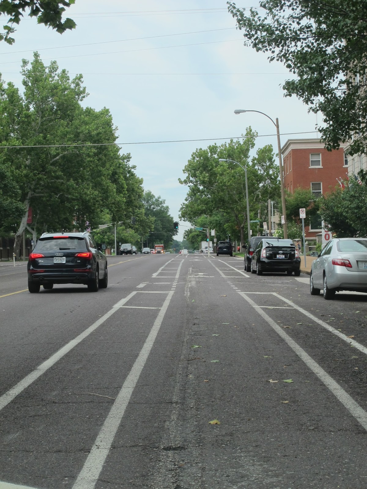
Protected bikeway with margins on both sides and
occasional bollards

one of those deserted downtown streets near  Union Station
(Olive Street)

Market Street


Downtown ballpark: Who doesn't have one now?


The Metrolink Station at Union Station
Klaus Philipsen,
The huge Union Station train shed, no in part an indoor mall,
a hotel and a lake with restaurants under an open roof


FAIA
The not so scenic western outskirts of St Louis

Monday, July 20, 2015

McKeldin Fountain catches Council President's Attention

The ongoing debate about the future of McKeldin Plaza has now sperad from UDARP to the council and motivated the Council President to possibly introduce a bill which closely tracks some key requests that AIA Baltimore has recently published, namely that no demolition of the existing fountain should occur before traffic is resolved and realization of a final phase assured.

According to the Baltimore Brew President young made these comments:

“We want to know how much it is going to cost, how long it’s going to take, who is going to pay for it,” 
“The Downtown Partnership is not a city agency, we are a city agency. They should be showing their stuff to us.” 
According to the designers, the demolition of the fountain is predicated by traffic considerations and the assumed need for additional lanes on the west side of the plaza should the spur on the east side be closed. However, a traffic study has not been finalized and the conclusion may be premature. Furthermore, one could question if traffic engineers should have the last word when it comes to the future of Mc Keldin Plaza since their past approaches around the Inner Harbor, no doubt, created the many of the problems that the Harbor 2.0 masterplan tries to alleviate.

Klaus Philipsen, FAIA

See Brew Article

Going West: Columbus and Indianapolis

Nothing irks natives of a city more than a tourist blowing into town and after a few hours making pronouncements that wouldn't hold the water if the stay would just have been a few hours longer. Nevertheless, it is fun, so here we go!

Columbus

Columbus, Ohio' namesake is a famous Italian but the city is famous for its large historic German Village and unlike Baltimore's  German Street it wasn't re-named into Redwood Village either.
German Village, German Flag and German food

Columbus honors the Italian with a replica of one of the three explorer boats but it lacks the water to make a good show of it.
German Village, a large quaint historic district
the type setting from where New Urbanists gleaned
their rules
But it is home to more than a dozen Fortune Five-hundred companies and it boasts a vivid and well stocked indoor Market that represents all that Lexington Market aspires to, a wide range of foods and customers. 
It's Sunday dead downtown was boosted today by some type of festival that in passing looked like Artscape but smaller. To the north of downtown Columbus has a well established arts district that is more Fells Point than Station North. 
In spite of beating Baltimore's population by a solid 100k, Ohio's capital has no rail transit at all and plenty of freeways instead. One of them is pretty cool covered by what looks like historic arcades. 


A bike parking place with roof in the arts district

A freeway cover of high quality (there is a corresponding arcade on the other
side of the street

A view to the south into downtown, a jumble of scales

Short North Arts District, they still like their arches

North Market

North Markets is compact but full of good stuff

the outdoor market stalls on the parking lot adds a bit of flavor and
would be easy to do at Lexington Market as well


Indianapolis


Indianapolis, the capital of Indiana has also many freeways and no rail transit, is also larger than Baltimore (by more then 200k) and it's downtown streets are at least as wide as those Columbus, mostly one way, no less. Plenty of space for a Cultural Trail for bikes and peds ( the dual trail at the Inner Harbor on steroids), a neat idea to get folks to explore the city without needing a map or a plan. Problem is only that this "cultural" trail is pretty peripheral most of the time, but that is cool, because it gets you places you would normally not go to, especially if you have a bike which is easy here, since they have bike-share. They did also a lot of new things, ballparks, conventions center, museums, a canal walk and a State Park along the White River.

Like many of the newer cities the fabric of the core is very eroded by freeways and huge surface parking lots like we know them in Baltimore only in the vicinity of the JFX downtown. But the real inner core of Indy is pretty intact and lively with restaurants and an amazing array of retail including a road spanning downtown mall. Best of all, Monument Circle gives downtown a real heart, even if the buildings surrounding the monument do not stack up to the architecture we have around Baltimore's Washington Monument which sits, not really in the heart of downtown anyway. Massachusetts Ave is a street with an industrial past (Coca Cola bottling, for example) and a eating and drinking presence. There is a rails to trails bike way going north to the little arts town of Broad Ripple. There is Also the vast expanse of an abandoned sports facility where nature is trying to take over the ocean of asphalt. 


On a road trip time on the computer really isn't a high priority, therefore I will just post a bunch of photos and let them speak for themselves.

Indianapolis Cultural trail, a way to explore the city

Monumental, axial and a bit sterile

Scales at Monument Circle

The monument is dedicated to war heroes

covered intersection downtown (mall above)

the new native Indian Museum


a re-purposed bridge over the White River is now part of a State Park and trail


Klaus Philipsen, FAIA


This article still needs refinement

Saturday, July 18, 2015

An American Road Trip. Part 1: I-70 that wasn't

To say this right up front, I would prefer a railroad trip across the country but my road trip has a purpose, a meeting in Denver plus the delivery of a car and so it will be driving US 70 all the way. 

There used to be a sign on I-70 here near where this over 2000 mile long Interstate ends in a dumpy park and ride lot that pointed to all the furthest destinations you can reach on this freeway that includes some of the oldest sections of the Eisenhower Interstate system.
The western terminus of I-70 used to be indicated
near the eastern terminus in Baltimore

Google says the trip to Denver is 1,655 miles from the City line and takes 23 hrs and 15 minutes without traffic.  Since there will be traffic and the car that can make such a trip without refueling needs to still be invented, I opted for a three and a half day trip with some sleep in between and looking at some cities that I hadn't seen in a while.

I will share little anecdotes that may be of interest here on this Daily Blog.

The first memorable fact can be reported before even leaving the house. It has to do with the not so glorious end of the storied cross country route and how it is linked  to the Red Line.

By thankfully killing the final miles of  I-70 that would have met I-95 at Caton Avenue, the Interstate did not cut across Leakin Park and did not destroy it. (see a more detailed report below). Only bits and pieces, including the link to downtown (the "highway to nowhere"), were built and they were already destructive enough. But from a transportation perspective, the never completed interstate connection means a missing link in east west transportation. The Red Line was supposed to fill the gap via transit.

The end of I-70 would have been re-purposed to become a large commuter rail station with a park and ride lot serving all those who want to enter the downtown business district from I-70 and today crawl down Cooks Lane or from US 40 clogging up Edmondson Avenue.
this is how 2200 miles of interstate end: at a
park and ride

But you know, the Governor is not from Howard, Carroll or Baltimore County and even though he is a self-proclaimed highway guy, he may not be that familiar with this particular part of Baltimore's transportation history and the connection needs that remain unmet.

Klaus Philipsen, FAIA


The Federal-Aid Highway Act of 1944 authorized designation of a 40,000-mile "National System of Interstate Highways." The Public Roads Administration (PRA), as the U.S. Bureau of Public Roads (BPR)/FHWA was called in the 1940's, asked State highway officials to submit proposals for Interstate routes. Eventually I-70 would make it into the system, but much later....
Community leaders walk the area of the I-70 terminus in the
fall of 2014 to demonstrate for a bridged trail
connection from the Red Line stop to
the Gwynns Falls green-way in Leakin Park

....the Baltimore segment of I-70 ... faced opposition. On July 28, 1981, Governor Harry Hughes of Maryland and Mayor William D. Schaefer of Baltimore requested withdrawal of a portion of I-70 from the Interstate System. FHWA Administrator Ray A. Barnhart and UMTA Administrator Arthur E. Teele approved the withdrawal of I-70 from Security Boulevard just inside the Baltimore Beltway (I-695) to the I-170 spur on September 3, 1981. (Security Boulevard was named after the nearby headquarters of the Social Security Administration.)With this action, the Interstate System in Baltimore retained the I-170 spur (3.35 miles) and the unbuilt I-70 segment (2.22 miles) from the spur to I-95 east of Caton Avenue. Because they were disconnected from I-70, the two segments (I-170 and I-70 between I-170 and I-95) were combined and renumbered I-595 as an I-95 spur in 1982. However, on July 22, 1983, Governor Hughes and Mayor Schaefer requested withdrawal of I-595 from the Interstate System. Administrator Barnhart and Acting Administrator G. Kent Woodman of UMTA approved the withdrawal on September 29, 1983.As a result of these actions, the eastern terminus of I-70 is a park-n-ride lot near the Social Security Administration complex just inside the Baltimore Beltway. (source)

Friday, July 17, 2015

Roads to nowhere

Baltimore has a famous "Highway to Nowhere" and it destroyed several neighborhoods, the same ones that got again the shaft when transit was cancelled that would have given that corridor at least some meaning. The communities had spent hundreds of hours planning around their planned stations.
SHA brochure

But there are other highways to nowhere: One of them is route 404. And I don't mean that it ends at the beach, for many that is somewhere. I don't mean even that it ends in Delaware which shouldn't be necessarily the prime destination for Maryland's expenditures. What I mean is that the highway engineers of Delaware are in no hurry to make their parts of the trip (DE 16) a four lane highway or even avoid towns, lights and turns. So they Maryland freeway goes nowhere. But hey, as far as I am concerned, I prefer travel on the slower curvy Delaware segment anyway. It gives a much better flavor of the Eastern Shore.
Maryland supports economic development in Delaware: Dolphins rejoice

But the point of how wasteful such highway spending really is becomes clear when you read this story. It shows with numbers what many of us know anecdotaly. When it comes to road building, there is no scrutiny. The asphalt lobby always wins, the pet projects of local politicians always get built and hardly any questions get asked. 

The irony: Route 404 gets widened for weekend beach goers to spend money in another state with the money that got pilfered from the Red Line coffers so that working weekday Baltimore commuters will continue to get stuck on congested roads. Go figure.


Klaus Philipsen, FAIA


Wednesday, July 15, 2015

Middle Branch, the domain of Under Armour?

After it has been made public that Under Armour now owns the area where the Baltimore SUN print facility sits and the Westport area where the BGE and Carr Lowry Glass company used to be before Pat Turner leveled them for his ambitious new Westport plans, Under Armour has a firm grip on the Middle Branch. They are also the owners of Nicks Fish House now and control the marina in front of it.
what Under Armour owns (Sun graphic)
A look from Light Rail to what used to be the
Carr Lowry Glass Company in Westport

This can be a good thing, certainly it doesn't have to be bad. I have likened UA to the new Medici of Baltimore in the sense that they are a power house in a city and that a lot of investment comes through them. The Medici brought lots of arts and culture to Florence. If Kevin and Scott Plank, founders of an enterprise that is more locker room than Louvre but there is always hope. Meyerhoff didn't start out so high brow either. The Planks first out of sports apparel endeavor is more spirit than spiritual, though, a whiskey distillery with visitor center and tasting area.

The Urban Design Committee of AIA has eyed the Middle Branch as Baltimore's "second waterfront" since 1990.  The Planning department in Masterplan has relied heavily on the Turner plans for the Westport shore line. It will be important now, to update those plans while the Planks are still figuring out what they want to do. Public interest, water access and recerational areas need to be asserted and nailed down now.
City Middle Branch Masterplan (Future Land Use)

A letter written in 2005 has still a lot of the right components, even if the Warner Street area has been ruined since then by the Casino and its mammoth garage. (see below).
The Middle Branch, a softer and quieter more natural waterfront


The Middle Branch is an exciting opportunity for Baltimore once more to think about water, yet in a new and different way. The Middle Branch as a softer, more natural and quieter urban waterfront.

Klaus Philipsen, FAIA

Links:
Baltimore SUN article about Under Armour Westport purchase
BBJ article about Under Armour Westport purchase

Cover of a 1990 Middle Branch Report of the AIA Urban Design Committee


from the 2005 AIA Letter of the Urban design Committee to the Planning Director:

On behalf of the Baltimore Chapter of the American Institute of Architects Urban Design Committee, I would like to thank you and the Planning Department for sharing with us your planning vision and efforts toward planning for the redevelopment of Middle Branch.  We very much appreciate the opportunity to meet with you, have a personalized presentation on your planning efforts to date, have our admittedly loud voices heard, and in general, participate in the planning for future development of Westport. 

Based on your presentation, our committee would like to share with you our thoughts for consideration as you move forward with your planning efforts.  In general, we applaud your effort to try to stay ahead of the development and to begin to establish a vision for public and private investment.  We felt that your presentation was thoughtful, and clearly, you and your team have been working hard to work through all of the complex issues that affect the redevelopment of this area.  We do, however, feel that some additional consideration and thought should be given to take the planning for Middle Branch to the next level.  As such we have listed some of our ideas below:


1.      Consider that there is more to Westport than just the waters edge.  Planning should extend beyond deep into the heart of Westport, and to a certain extent, beyond I-395 westward into the city.  Westport is inexplicitly tied to the greater urban environment. 

2.   The planning department should coordinate transportation planning efforts with the city and state to proactively plan for better access to Middle Branch.  The potential volume of traffic generated by new development could be significant and if not planned for could have a negative impact on development potential.  An improved Annapolis Road connection to downtown, a Waterview Avenue connection, improved I-295 access, are critical and could be defined as gateways into the area. The Warner Street district should be considered as a vital connection to and extension of downtown.  Additionally, planning should include pedestrians and potential access to the stadium and an extension of the greenway system into the area.
  
3.   Ensure that open space corridors, possibly boulevards, are created to ‘bring/pull’ the water back into the development. Possibly connect these corridors with waterfront open spaces, green, or perhaps hardscape at a major activity node that would frame views of the Hanover Street Bridge. 
  
4.   Require all development parcels to create a pedestrian promenade along the waters edge and establish, thought zoning, a generous setback to ensure public access to the water.  Additionally, access can be defined as more than a series of vertical and horizontal strip zones along the water; it can be modulated vertically and horizontally as a series of dense and open areas reaching back into the community and up from the shoreline to establish view corridors. 

6.    Consider enacting zoning ordnances so that the vibrancy of potential redevelopment of Main Street is not jeopardized by the new waterfront development. .  A commercial zone could be established along Kloman Street to activate the Westport neighborhood while still connecting to the green waterfront zone.  This would tend to add to the vitality of the district instead of draining it.

7.   Alternate taller, denser areas with open, lower areas for visual waterfront access throughout and into the development.  Localized density can be achieved in the neighborhood of the transit station without disconnecting Westport from the Middle Branch, and the buildings can interface with the water in a number of different ways (low and mid-rise).  Consider hiding parking within the building massing.    

8.   Adjust presentation graphics to convey ‘green’ areas (currently delineated in brown) are green and read as green areas.

9.   The area around the Middle Branch “basin” might be considered as a series “communities” within with the Middle Branch as the common element.  The Westport shoreline is an opportunity to create a mixed-use “Village” along the water.  The parkland is more of a green zone, while the opposite shore can be defined as a low-lying institutional/business/etc. area with increasing mass and height towards the peripheral roadways.        

After the Red Line - can there be a "Plan B"?


After the death of the Baltimore Red Line at the end of a 10 year plus full project development the question "what is plan B?" could be seen as, well, inappropriate.

As inopportune as asking a couple the morning after a miscarriage what their plans for another baby are. Or offering them a cuddly consolation prize in form of a hamster or rabbit.

Or, if this analogy, in which the next baby could be light rail without the pesky tunnel or transit without rails or the cuddly rabbit in form of a spruced up Quickbus, is too tasteless one could talk about process.

Process as in that something that had emerged as a regional consensus could not overnight be replaced, even if one forgoes federal funding and FTA New Starts procedures. That good planning and thorough vetting are still needed to build a new consensus, get buy-in from as many sides as possible, achieve a design that can be built, funded and constructed and performs well.

Typically, even with a "do it now" mentality this is not a matter of 30 days and usually not even of one election cycle.  Just like a couple that wants to build a house. After months of checking neighborhoods and alternative designs they finally buy a piece of land, hire an architect, review and revise designs until they have the perfect fit. They get zoning and permits approved, and a mortgage applied for and approved. The invitations have gone out for the groundbreaking party.

Imagine, that is when the husband decides he'd rather spend the down payment with his buddies who have been feeling quite neglected by all this attention to his marriage and new house. So they go on a series of happy hours, revive the good old days and get really loaded in the process.
Alternative streetcar? New streetcar model (Toronto)

That husband may not be in a good place to ask what plan B is. The husband's buddies all have already popped their champagne corks and are salivating over the down payment. In that situation, can "Plan B" reasonably be another house with a different design, possibly in a different neighborhood when all the money is pretty much taken off the table?

Or, given the urgency to get peace, is it to be a mobile home this time? A houseboat, a tent? The latter two sweetened with the rationale that they can be much easier moved and need no permit? 

Back to the actual situation: The "do it now" quick and cheap original light rail line demonstrated in part that not vetting alternatives in the beginning has its problems, too. 

The Red Line had followed the FTA process, alternatives 1-4 were presented in 2008 under Governor Ehrlich. Included were a no-build option, surface bus, surface rail, tunnel bus and tunnel rail. Each was priced, ridership models were run and performances anticipated. Option 4C was announced in August 2009 by Governor O'Malley as the locally preferred alternative (LPA).

Between not vetting alternatives or vetting them but coming up with the [politically] "wrong" result, its hard to imagine plan B. Still, the new Secretary of MDOT already has asked the MTA for "plan B". The Governor reported his staff is looking at "a dozen options" and expressed disappointment that no jurisdiction has presented their Plan B yet.
“So far we’ve heard a lot of complaints about ‘We didn’t get what we wanted’ . . . but we haven’t heard a single suggestion or an alternative. ." (Hogan)
Sounds like we will enter a high season of many plan Bs. Lots of folks will take this as an invitation to dust off their napkin sketches for transit and transporation. What better occasion to suggest "alternatives"? What can be expected is much less transit planning than political bartering further fueled by upcoming mayoral elections. But as the saying goes, disaster up side down spells opportunity. Just a $2.9 billion cheaper opportunity.

Klaus Philipsen, FAIA

  
Alternative Rapid Bus or Bus Rapid Transit?

It will be up to the communities of this region if they discuss the tent, or a rabbit or a new baby after all. 


Link to WYPR where BRT and Rapid Bus is explained. (Click the "listen" button)

There are three key phases in the planning and project development process for projects seeking New Starts funding: 1) Alternatives Analysis; 2) Preliminary Engineering; and 3) Final Design. 
These phases are described here.


The Senate Budget and Taxation Committee and the House Appropriations Committee are holding a joint hearing on Tuesday, July 21st at 3:00PM about the Red Line decision. The meeting will take place in the: Joint Hearing Room in the Dept. of Legislative Services, 90 State Circle, Annapolis, MD 21401 


Tuesday, July 14, 2015

How Baltimore County sprawls in the middle of a growth center


That sprawl doesn't have to be development of far-flung farm fields but can also be development right at a major freeway interchange and in a designated town center area can be observed in White Marsh. This area defied its Town Center designation from the beginning. It did absorb growth that may have otherwise gone outside the rural urban demarcation line (URDL) and as such was a sprawl fighter. Aside from that distinction, though, it has all the characteristics of sprawl. Complete separation of uses, residential subdivisions that are completely disconnected from the commercial and the retail areas, 100% auto dependency aside from a park& ride lot served by buses (which essentially serve automobiles) and an utter lack of sense of place.
White Marsh Mall (left) isolated, surrounded by parking. 

After decades of growth one would expect that eventually some urban form would emerge, but not in White Marsh. Commercial flex warehouse developments have spread across I-95 (a huge non-walkable barrier) and the latest proposal is just another not walkable mall sitting there in isolation siphoning energy from the first one.


The stellar place-making qualities are on display among these flex warehouses east of I-95 right off Franklin Square Drive
Imagine for each parked car two people walking , imagine all those uses pushed together until they form tight streets, now
that would be a town center!


Belmar Mall redevelopment, near Denver Colorado
Klaus Philipsen, FAIA

Malls to Mainstreets