Tuesday, April 26, 2022

$20 million public money for the ailing Security Mall

 The entire Southwest Baltimore County political echelon including House Speaker Adrienne Jones was assembled when County Executive Johnny Olszewski  announced that $10 million State and $10 million County money would be set aside for investment at this ailing 100 care mall site tucked in between I-695, I-70 and Security Boulevard. Olsziewksi described the mall as a one thriving hub which he imagined to turn again into a "world class shopping center and and community hub". To help matters along, the County will retain architects and planners to guide a "community driven design charrette".

County Executive Olszewski announced $20 million for 
Security Mall (Photo: Philipsen)

The backdrop for the open air press conference were some back hoes and the remnants of an old Bennigans and I-Hop which had sat as abandoned eyesores along Security Boulevard for years. A couple TV stations had come out, and the print media took notes. 

Speaker Jones, who hails from the area, noted Security Square Mall still remains a vibrant place for many local businesses and an important part of the community. She observed that the communities of the Southwest have often reminded her that the property needs significant revitalization and investment. “This $20 million investment will jump-start this effort and help bring new life to the community.

Council chair Julian Jones recalled the year 2015 when the construction of the $2.9 billion Red Line should have started with a stop "right here where I stand", Jones said. "That would have brought investment to this mall, but now we will do what is necessary, he said and thanked the Executive and the Speaker for their efforts of securing the funds.
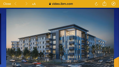
Mall redevelopment with housing in Santa Ana, Ca

Of the 5 mall owners only the latest operator spoke, the pastor of the "Set the Captives Free" church, Karen Bethea, introduced as "a force of nature" spoke. The church has bought the former JC Penny wing of the mall and operates community outreach, education and soon a daycare center in the mall. The possibly most outspoken and powerful owner, Howard Brown, was not present. A few years back he was the first to publicly present the idea of a new mixed use town center on the nearly 100 acre mall property. He was convinced he could strong-arm the other parties into his vision. Albeit, this didn't happen.

Brown thinks little of the replacement of the abandoned I-Hop with a new Chick-Fil-A, planned in the same location. This plan follows a defeated gas station and is seen as an improvement by some who are tired of the abandonment and trash. However popular, in terms of urban design and land use Chick-Fil-A is not different from the other 1-story drive to or drive through "pad uses" that ring the mall. Those structures will simply be in the way if the NAACP's Task Force preferred vision should be realized which was developed with strong community participation. The preferred scenario envisions a mixed use urban village with a "main street" lined with higher end retail, market rate housing, some offices, urban parks and civic uses.

The NAACP vision was not mentioned in today's press conference, and none of the task force members got to speak about their vision. Instead, the Executive  spoke  of "a blank slate". Mall redevelopments around the country show, that conversions of old malls into vibrant towncenters don't happen easily, and certainly not without strong leadership. Ryan Coleman chair of the Randallstown NAACP and Danielle Singley, the Task Force Chair know how difficult it is to unit people behind a common goal. Both were at hand at the press conference but stayed in the background.

Demand for retail space is declining while housing needs are unmet
(From a mall redevelopment presentation)

Especially since communities around the mall have already spoken in an at least preliminary manner, there wouldn't be anything wrong with County leadership uniting around the concept of a mixed use center which would not only provide much better services for the community but also provide jobs and become and economic engine in the area which has seen declining school performance and increased crime.

A $20 million investment is a great start if the money is used as a seed to facilitate that all stakeholders rally around a new vision. With potentially millions of additional square feet of use (the current mall on a mostly vacant lot covers an area of about 1 million square foot of use area) nobody would have to fear displacement. Lots of "stuff" could be developed on the vast parking lots long before any part of the mall would have to come down and there would be still room for green open spaces and parks. 

Experiences from other redevelopments show that a new masterplan should not only be developed but must also become legally binding. Public investment in the roads and the infrastructure needed for a new town center could facilitate the creation of fully "entitled" development parcels. Ready to build development parcels right at the Beltway would attract new investors and wake up the current mall businesses from their slumber. In this manner the County-State funds could, indeed, become the first step for a new community hub that is also an economic power-house.

While the new masterplan is being developed in the "charrette" process starting sometime this year, no new development should be allowed in the interim. However, it seems not only Chik-Fil_A is an offender; the County administration itself  is already creating new facts on the ground with a new $1.2 million 8.8 thousand square foot community health center planned in collaboration with the church. Not helpful, should the masterplan recommend that the mall should be leveled, as for example, at the old Rockville Mall in Montgomery County.

With new elections for a Council and Executive with the seat of district 1 vacated by Councilman Tom Quirk, champions of a radically new development model can yet emerge. All three candidates vying for Quirk's seat were present at the press conference today. 

Olszewski himself, whose seat is safe, when asked about a development moratorium during the planning stage responded: "Speak with the Council!". 

Klaus Philipsen, FAIA


Previous mall articles on this blog:

How the failed Security Mall could become a thriving town center (July 2021)

Howard Brown plans second County Town Center (March 2017)
Wednesday, April 13, 2022

Druid Park Lake Drive: Baltimore's struggle to implement a new transportation paradigm

Across America transportation and public works departments are trying to wean themselves from decades of following a single paradigm: Make car traffic flow as freely as possible. Baltimore's BCDOT was a leader in making this happen. 
Car centric design: Lots of space for cars, little for pedestrians. 
(Image from TAP, 


Shaped for half a century by the likes of Henry Barnes, an influential traffic engineer who as traffic commissioner shaped the streets of Denver, Baltimore and New York with innovations such as the "green wave" of synchronized traffic lights and the world's first big main frame computer installed in Baltimore to control the signals from a central location. He also invented the "Barnes Dance", a special signal sequence to deal with the pesky pedestrians that tended to cross streets at all times.

Since then, the computer obsolete, and new technologies apparently hard to make work, Baltimore's drivers would wish the lights still had a "green wave". But otherwise the legacy of post-war traffic engineering is still in place, the one way streets (which are a precondition for synchronizing lights), the multi lane arteries with left turn bays, the fragments of freeways channeling suburbanites to their offices downtown and back home.
Druid Hill Park: An asset chocked off by roadway barriers


At Druid Lake Park Drive two elements of Baltimore's rich history collide. The 740 acre  beautiful Druid Hill Park designed by Howard Daniels and opened in 1860 and the 100 year later Henry Barnes inspired Johns Falls Expressway with its complicated multilevel ramps and tendrils choking the park on three sides with in the shape of fast multi-lane feeder arteries arteries. This reduced park access points from 18 to just 5. The matter has become ever more deplorable, the more Baltimore's surrounding neighborhoods fell into disrepair. In 2017 Baltimore architect Davin Hong summarized the problem in a SUN editorial:

Baltimore's Druid Hill Park ranks with distinction among a very short list of large historic urban parks in America. With a pastoral landscape, picturesque reservoir and even the Maryland Zoo, it is a popular destination for not only Baltimore residents but also for visitors from the surrounding region. Yet somehow, its bordering neighborhoods have not benefited from being next to such a landmark amenity. They have not thrived as sought-after communities and are instead deserts to recreation, greenery and quality of life.
Certainly, there are many complex factors that shape the health of communities and that make their success so elusive. But there is one very obvious reason why Druid Hill Park does not contribute to its surrounding neighborhoods: It is bordered by very wide, fast streets that act as physical barriers, separating the park from its surrounding communities as a green island among a sea of asphalt arteries.
Shortly afterwards, Daniel Hindman a community member and physician, added the equity and health angles in another SUN editorial
This photo of the construction of the JFX shows the extent of impact
urban freeways had


While many know of the racism of the park’s past — the segregated swimming pools, tennis courts and playgrounds — many do not know the politics and history behind the construction of the Druid Hill Expressway. The story of the expressway’s construction is a narrative of racism and corruption, that, like an arrow shot from the past, inflicts damage on our most vulnerable populations today. ...The impact of this history is evidenced today in the 2017 Neighborhood Health Profiles, which demonstrate that Reservoir Hill and Penn North, communities that border one of the largest urban parks in the country, have some of the highest rates of cardiovascular disease in the city. 
Back then those editorials and other activities finally initiated action. However, now with lots of ARPA and federal infrastructure bill money in reach and a much more progressive DOT leadership in place, Baltimore is in danger of missing a critical opportunity. 

Let's recap what happened: The current DOT Director Steve Sharkey is attacking the old ways of car centric thinking on several fronts. 
As Director, his top priority is to focus BCDOT's efforts on initiatives that better serve all users of the transportation system to improve walking, biking, transit and driving in Baltimore (DOT website)
The new paradigm isn't entirely by Sharkey's own making, it also is local law after the City Council  finally approved "complete streets" legislation in 2018 after years of deliberation. The new set of rules gave former DOT Director Pourciau headaches, but they also initiated the Druid Park connectivity project when DOT installed an experiment dubbed "the Big Jump". The experiment was funded by a grant. The complete streets legislation was in its final round.  Then local councilman Leon Pinkett had  organized stakeholders and residents with the goal of leveraging Druid Park for revitalization and provide better access and more equity for those who aren't drivers. The resulting TAP coalition describes itself this way.
Overpass over the JFX at 28th Street before the "Big Jump":
Little room for pedestrians, fast moving traffic

TAP Druid Hill is a coalition of residents, city officials, and community partners working together to increase access to Druid Hill Park for people on foot, wheelchair, transit, and bicycle / escooter. (website)
The Big Jump which opened with a party in 2018 and is still in place, consists of  temporary “pop up” mixed-use trail along Druid Park Lake Drive protected by water filled plastic barriers. The trail proceeds west from Madison Street, across the 28th Street Bridge, and along 28th Street to Atkinson Street.  Additionally, over in Remington, a flex post delineated bike lane was created on Sisson Street from 28th Street to Wyman Park Drive; In part the Big Jump project was making up for the loss of a loop trail around the Druid Lake reservoir which was the result of a giant $140 million DPW project going on inside Druid Hill Park: With 52 million gallons the world's largest underground drinking water reservoir under progress at the park's lake.
Overpass after the Big Jump installation (DOT)


Pop ups like the Big Jump provide an immediate benefit and allow engineers and stakeholders to obverse the effects of an intervention in a real world simulation that is cheaper than lengthy studies, easy to modify, or, if necessary, to abandon. An evaluation of the Big Jump performed by Toole Design, a consultant to DOT showed, that the resulting single lane of traffic in each direction did not lead to a noticeable increase in travel times on the roadway and did not push traffic into other areas either. 87% of folks who expressed an opinion wanted the "Big Jump" solution become permanent.

BC-DOT's new attention to other road users than car drivers puts the department at the forefront of the many current US culture wars from education, LGTB rights, and guns, to bikes and electric scooters. Thus DOT is at odds with the perceived right of driving unimpeded through American cities. In Baltimore, Sharkey's predecessor Pourciau wavered on several early bike lane installations and lost a major battle in the prosperous Roland Park corridor. There were lessons to be learned for the Druid Park project, and indeed, it was much better prepared with much more outreach.

Sharkey's refocused DOT defines the Druid Lake problem in much the way road critics had described it:
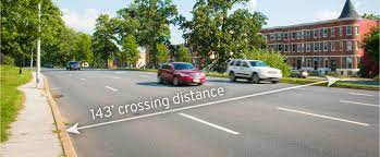
While the Druid Park Lake Drive corridor borders the United States’ third-oldest public park and beautiful historic neighborhoods, the roadway is designed with the characteristics of a highway, rather than a neighborhood-scale roadway. Originally a two-lane residential street, the current alignment of Druid Park Lake Drive is now a 4-to-9-lane arterial road that carries high-speed vehicle traffic, lacks safe pedestrian, bicycle and transit infrastructure and effectively creates a barrier between neighboring communities and Druid Hill Park.

 That the streets are also seen as a battlefield for equity and social justice just heightens the tensions. DOT's Druid Lake Park Drive report  ("The Report") says:

Councilman Pinkett (speaking), Mayor Pugh in 2018
at the Big Jump opening party (Philipsen)

The neighborhoods bordering Druid Park Lake Drive are predominantly Black and have experienced generations of disinvestment, racial discrimination, poor public health and decreased quality of life [....]

Equity is a driving factor for the redesign of Druid Park Lake Drive, and ensuring access for all modes, ages and abilities is a key component in creating an equitable corridor. Demographic data for the area within a half-mile and quarter-mile radius of the corridor illustrate what equity means in the context of Druid Park Lake Drive. Of the 88,000 people living within a half mile of Druid Park Lake Drive, 30 percent live below the poverty line, 22 percent live with a disability and 93 percent are people of color.1 Nearly half of households living in the neighborhoods around the Druid Park Lake Drive do not have access to a car. These community members get around by walking, cycling, using wheelchairs, riding scooters and catching transit. Building infrastructure to allow these residents to safely use Druid Park Lake Drive is key in advancing equity. 

After several initial community participation meetings DOT developed a vision:

We envision a reimagined Druid Park Lake Drive that is safe, built for the human scale and accessible for all ages, abilities, and modes of transportation. This future corridor will closely align with the City’s Complete Streets principles, while creating a functional, vibrant, and aesthetically pleasing roadway that reclaims roadway space to re-establish safe multimodal connections between surrounding communities and the park and embraces the area’s natural beauty and historic significance. Through the redesign of this corridor, we aim to  elevate health equity, allow communities to support aging in place, and support expanded transit service to Druid Hill Park.
The community based approach, the outreach, the grant funding, the problem definition, the experiment and its evaluation were all great moves. But where are we now? 
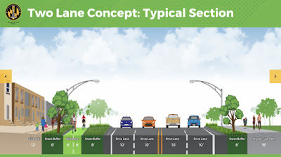
One Lane option and bike/ walkways: 779 votes  (DOT)


Some 5 or so years after inception and 4 years after installing the pilot, the project should be well in the implementation phase. Instead: analysis, paralysis. No money is in the budget for construction, an avoidable condition..

In late 2020, BCDOT retained the services of  WSP, a transportation planning firm. The engineers developed three alternatives for right-sizing Druid Park Lake Drive corridor, more similar to what it was before the expansion after I-83 was built. All three design versions share a 12-foot sidewalk adjacent to residences, three 8-foot “green buffers,” and a 15-foot shared use path adjacent to Druid Hill Park. One of them left like the Big Jump just one travel lane for cars per direction. Another moment for the community to chime in: Which option to build?

The new paradigm and the prospect of a "road diet" predictably drew the ire of ardent promotors of unfettered automobility. A small but vocal and prolific "Save our Streets Coalition" operated under a motto that would make Barnes proud:
Two lane option: 170 votes (DOT)

We are citizens dedicated to fighting efforts to alter city streets in ways that promote traffic congestion (Facebook page)

The group has blanketed the neighborhoods with yard signs and dubious messages against bike lanes on Gwynns Fall Parkway (part of an envisioned big bike-ped loop around Baltimore) and on Druid Lake Park Drive. 

The bike lobby Bikemore and the car lobby Save our Streets called upon their followers to weigh in on the three design options which were polled early this year on DOTs website. Neighbors, of course, voted, too. The results are very clear: 779 votes opted for Option 1 which proposed only a single lane of cars in each direction, 170 voted for option 2, with two lanes of traffic in each direction. Only 15 votes for a hybrid option with 2 driving lanes in one and 1 in the other direction.

Save Our Streets coalition poster: Free to drive
 

In this culture war reason was winning. Luckily the future design isn't really decided via open polling. Ex-councilman Pinkett's foresight of organizing local stakeholders and putting them in the "driver's seat" (or into the "Big Jump") pretty much ensures that nearby residents will have a voice when it comes to what gets implemented when. . The engineering evaluation showed no downside to the preferred single lane solution, neither in modeling nor in the real world application. So what stands in the way of implementation? Why is the project not  funded for construction, in spite of all the extra federal funding for infrastructure and Covid recovery? The current capital improvement program (CIP) shows no money for the project which is estimated to cost around $30 million in all. It isn't too late to amend the CIP. It is not too late to comment on the DOT report . The comment period for the ends this week Friday. 

Bikemore director Jed Weeks observes that the drawings for the three options are not yet the 30% design level that usually justifies the first tranche of implementation funds. Even when funded, it will take long enough to build the project. William Ethridge, the DOT planner for the project, estimates that it would take 5-7 years to get the project completed, once money is set aside, that is.  

Now is the time to "jump" into implementation. Maybe it takes a decision of the Mayor to finally implement this project and signal that once and for all, Baltimore's transportation paradigm has shifted. 

Klaus Philipsen, FAIA


Related on this Blog: What is the Big Jump all about?

Friday, April 1, 2022

Good News Baltimore: Transit Oriented Development at Metro Station

 One of the problems with Baltimore's rail transit isn't really about trains, service or reliability and isn't the sole responsibility of the MTA, MDOT or that the Governor. The problem I am referring to is "land use". In other words, get off a train at most of the metro, light rail and MARC stops in Baltimore City and County outside of downtown and there is not a whole lot going on. The urban form around most Metro and MARC stops resembles a hole in the donut, the opposite of what it should be. Therefore, the news that MDOT plans to convert one of its parking lots to a "town center" and has selected a local development team is good news.

Reisterstown Plaza TOD area (MDOT)

On December 13, 2022, the Maryland Department of Transportation (MDOT) awarded for entering into an exclusive negotiating privilege agreement with Wabash Development Partners to develop approximately 25 acres (approximately 3 acres zoned TOD-4 and 22 acres zoned TOD-3) of unimproved land and surfaced parking lots. The area is a large parcel of land adjacent to a Reisterstown Plaza Metro Station located at 6300 Wabash Avenue in Baltimore City, ideal for a Transit-Oriented Development (TOD). This site is at the highly visible intersection of Wabash Avenue and Patterson Avenue. An internal private road, Vertis Park Drive, shared by the MDOT Maryland Transit Administration (MDOT MTA) and the adjacent SSA building, provides vehicular access between Patterson Avenue to Mount Hope Drive.  (MDOT Press Release)

Better land use is good for transit. It is surprising how rarely land use is seen as a solution for increased transit use. Intensified land use at rail stations is also good for urban development, it is helping to combat climate change and, combined with affordable housing, it provides opportunity for those who don't have a car. Instead of the hole in the donut, one should see high density and high intensity uses clustered immediately around each station in the region including those "drive to" commuter stations which were designed with giant parking lots. This conversion is often referred to as "transit oriented development" (TOD). 

Wabash Avenue and the Metro Station (Photo: Philipsen)

Of course, the concept of TOD isn't new and even the original planners of the Metro system had ideas for development nodes around their stations as some old brochures prove. But history wasn't kind to Baltimore, the city emptied out and the once proud high capacity Metro found itself sitting in just those areas that are now known as the left wing of Baltimore's famous "butterfly". Today, with equity on planners' minds, a housing affordability crisis, and Park Heights being designated as one of Baltimore's Impact Investment zones, it makes sense that the simplest version of TOD is tried once again: The conversion of MDOT owned parking lots into housing and some other uses. And that is what the developer team proposes: Apartments for people that may not have, need or want a car such as low income families, the young and the elderly and people that can reach their work via Metro.  Baltimore's new zoning code uses TOD as a zoning category and states:
Baltimore elevated Metro Station: Greetings
from the 1970s (Photo: Philipsen)

There are many opportunities for Transit Oriented Development in Baltimore City. In the City, TOD will be used to focus on the connection between development and transit as the key to helping neighborhoods achieve their goals and to promote transit use, bicycling, and walking as alternatives to automobile travel.   Currently, our Comprehensive Master Plan, in Appendix D, outlines a TOD Strategy for implementing projects around transit stations that meet TOD objectives. Additionally, the Development Guidebook contains a checklist for Transit Oriented Development which is intended to guide Baltimore City agencies in reviewing proposed projects near transit stations, and in assessing the transit-friendliness of land-use plans, codes, and ordinances. (Baltimore City Dept. of Planning)
40 years after the Reisterstown Plaza Station was completed on Baltimore's one and only subway line, and nearly a decade after the Social Security Administration (SSA) was relocated here on 11 acres of State owned parking lots in a new 500,000 square foot building,  the conversion of the remaining 25 acres of parking  is now in the stage of "exclusive negotiation rights", in which the developers' envisioned project gets its final vetting before the site is actually sold. The Wabash Development team was selected over a competing proposal suggesting a family entertainment center and amusement park. The initial request of proposals had been issued in 2019, attesting to a somewhat glacial pace that will hopefully accelerated in the remaining steps towards realization.

To avoid past mistakes it is necessary to take a critical look at what has passed as TOD before, here or elsewhere in our region. For example, the already mentioned SSA facility, also on MDOT's land. It serves at stately workforce of 1,600 employees. But they were supplied with 1076 parking spaces. The assumption that 67% of all workers would drive to work isn't "transit oriented" oriented thinking. Not only does structured parking take up space and is very costly, it also encourages driving. The old now shuttered SSA downtown facility sat within walking distance of several neighborhoods, the Lexington Market Metro station and was served by various bus lines. All things considered, the much touted SSA TOD may have not only not brought new transit riders but may have caused additional driving. 
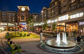
Pike and Rose near Rockville, TOD on a former mall site 
(Photo Philipsen)


Other local projects, previously labeled TOD, are equally hampered by parking: Take Symphony Center near the Meyerhoff, another project characterized by a giant garage, that has probably done little to enhance ridership on the light rail line. Or take Owings Mills, often held up as the best example for TOD in this region: Yes, it is large scale mixed use and creates a somewhat urban feel but it still mostly a mostly a park and ride station. The huge parking garage acts as a visual and physical barrier between the "town center" and the Metro station terminus of our subway line.  The probably locally best TOD is Clipper Mill in Woodberry. It wasn't really conceived as a TOD, but replaced abandoned space with a large, varied and creatively designed amount of  uses right near the light rail station.

The Wabash Development team under Dean Harrison with participation of Ernst Valerie and KPN as the Architects for the concept plan that was selected by MDOT suggests four phases of realization for a number of different developments. The BBJ obtained an edited copy of the proposal dubbed "Wabash Town Center" through a public information request. The BBJ describes what it found out this way:
The first phase would yield two mixed-use buildings with office and retail space. One of the buildings would be up to 100 feet tall and the other would be up to 60 feet high. A road named after the late U.S. Congressman Elijah Cummings extending from Wabash Avenue to Vertis Park Drive would be also be created as part of the first phase.
The second phase would result in 20 townhomes with so-called "granny flats" and a 42-unit senior home [..] based on a similar concept at Johnston Square.

The project's third phase would create a pedestrian bridge to the nearby Social Security Administration campus. A pedestrian plaza called “Legacy Walk" would showcase community art and provide space for small events, a street theater, outdoor wellness programs, community gatherings and outdoor exhibitions. 
A fourth and final phase of development would include the construction of a "medium-scale" nursing home and space for food trucks and a farmers market.
If realized, those four phases together could have the elements that deserve the classification as TOD and maybe just enough density to be called "village center" or "town-center". Best practice examples show, that true TOD requires that the station, the development and the adjacent road ways together form a pedestrian friendly environment where it pleasant and safe to walk from and to transit or from the surrounding areas. 
Mosaic TOD Redevelopment, Fairfax County 
(Photo: Mahan Rykiel, Associates)


The Reisterstown Metro Station leaves a lot to be desired in the area of pedestrian friendliness. Conceived as a car friendly commuter "park and ride station" with some bus transfers the focus was and remains on easy car access from the freeway style 5 lane Wabash Avenue which separates the MDOT owned parking lots from the Brutalist era elevated concrete Metro Station. A covered pedestrian bridge connects the parking lot with the station above Wabash Avenue. Those high bridges with their necessary elevator and many dank corners creating safety concerns are less than ideal for the elderly, mobility impaired, or people with strollers, or after dark. 

For a real TOD transit and the development have to work like hand in glove. The station itself needs some redesign and adjustments for direct, easy and safe access. This means three parties have to work closely together: The developer, the MTA and City DOT. 

The good news is that upon inquiry all parties appear to be ready for just that. City DOT's Capital Planning Chief Allysha Lorber stated that a grant application to modify Wabash Avenue is in the works. MTA is integrated by the fact that MDOT is the land owner who issued the request for proposals in the first place which demands coordination. The developer is interested to lower his cost by building as little parking as possible, even though, MDOT still requires replacement parking. In this location that is probably misguided since there are plenty of park and ride spaces on the stations up and down the line (other holes in the donuts).

Getting TOD "right" is an art. So much so that there is a national website just devoted to TOD. It shows a slew of representative US precedents from which to learn and that have gained recognition. Many are located in the DC region in WMATA's service area. Baltimore's developers need to study these examples, from Columbia Heights (DC) to Pentagon City, Clarendon (Arlington County) to Mosaic (Fairfax County) and Pike and  Rose (Rockville). 
Affordable Housing near transit by Enterprise Community Partners
Denver (See article

There is a lot at stake. Good development has ripple effects. Mediocre development just sits around and uses up space. Baltimore's rail transit urgently needs a shot in the arm. Even before Covid hit, the LRT and the Metro systems performed way under capacity with a shrinking ridership over the last decades. Now, after being hit by COVID and many office workers still working from home, the systems are barely limping along. 

One of the development partners on Dean Harrison's team, Ernst Valery, his investment and development firm is headquartered in Station North. The Columbia and MIT trained with a bacjelor in Planning knows how to do TOD. He is the developer of the Nelson Kohl apartments behind Penn Station with minimal parking. One of his largest  projects is currently in design in Richmond, California. Up to 870 apartments with minimal parking as well as a business incubator and some retail to be constructed in three phases, everything located within an easy walk to an existing Amtrak station and the terminal station of the BART line that connects Richmond to San Francisco. One can hope that this know-how will be successfully integrated into a truly successful TOD, one that deserves the label. 

Klaus Philipsen, FAIA