The antiquated commuter rail station at West Baltimore high above the two legs of US 40 where it transforms from the "Highway to nowhere" back to a normal urban thoroughfare has long been recognized for having lots of potential.
 |
| West Baltimore MARC station east side (Photo: Philipsen) |
Over the years many projects came and went on account of the pivotal importance of this station with its commuter rail connection to the airport and DC. Many projects, small and large, were initiated on account of parking, economic development, equity, transit oriented development and intermodal connectivity. The projects mostly initiated by MTA go back decades. Aside from lighting, shelters, landscaping and step repairs, the more notable initiatives involved the demolition of ramps, bridges and retaining walls at the abrupt western end of the freeway in favor of tripling the capacity of parking and finally the construction of a bus hub in which a number of bus lines converge and lay over on what was the parking lot closest to the rail station. A developer who had bought the historic ice house facility in hopes of a windfall when the original Red Line was planned eventually gave up after the Red line was killed after 13 years of planning in 2015. He never published a vision for the ice house property.
 |
| Governor Moore announcing the revival of the Red Line with the historic Ice House ruin as a backdrop (Photo: Philipsen) |
The incremental approach did not result in a convincing solution. Passengers can still board trains only on two doors via step stools on account of platforms that are ultra low, because the curve doesn't allow high platforms without forming a large gap. The shelters are still no better than bus stops and the many rickety steps leave anyone not entirely mobile stranded at the lower level.
The parking lots and buses are on the east side of the elevated tracks but the southbound trains to the BWI airport job center and to Washington's Union Station require access from the west side. This means folks have to squeeze alongside three lanes of traffic through the dark underpass on a narrow sidewalk.
What is infuriating, though, is that not even the multi-billion dollar Amtrak tunnel, the federal "Reconnecting Communities" grant supposed to address the ill fated highway and the planning for the Red Line light rail line, all converging right here did not yield a truly comprehensive design that optimally addresses economic development, transit oriented development, the Red Line and convenient fully accessible intermodal connectivity.
What Amtrak revealed as the new design last week leaves so much to be desired that calling it fatally flawed would barely be an overstatement.
 |
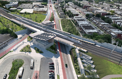
| Amtrak rendering showing the new station with its two head houses (Amtrak) |
True, multi billion dollar projects that take 10 years or more to plan and build don't necessarily yield creativity, innovation, or even a comprehensive approach. Federal laws such as the National Environmental Protection Act (NEPA) and the associated reviews and steps of the Environmental Impacts Statements (EIS) put projects into a sequential straight-jacket. The driver for the process is the original "purpose and need" determination. In the case of the new Amtrak tunnel, it is all about the high speed north-east corridor (NEC) in which the measly MARC train station is just a speck on the map, no matter that the slightly revised track alignment wipe out the current station entirely and open up all a full opportunity for an optimal intermodal station that is fully incorporated into the community.
Alas, that opportunity wasn’t seized. Even though actual construction on this end of the tunnel is years out, the local transit agency MTA who is in charge of the MARC station design and operation claims that it is too late to change anything. By releasing some renderings this week Amtrak and MTA were probably hoping that folks would be blinded the new headhouses with waiting rooms that are, indeed, a vast improvement over what is there today.
 |
| Close up view of the new station seen from the bus hub (Amtrak) |
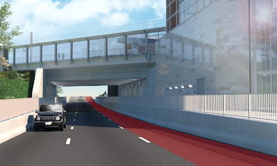
The complaint about the suggested solution centers around the completely baffling fact that the new design still assumes two underpasses, still has a solid earth berm between them and still requires riders to use the automobile underpass to get to the other side. In fact, Amtrak's own renderings perfectly illustrate how horrible this connection will be.
Maybe even worse, the solid center berm also prevents the Red Line from passing through under the center of the MARC station. Instead, just as the pedestrian the light rail, too has to use the underpasses utilizing the third traffic lane on each side. Possibly the worst aspect: The Red Line plans don't anticipate a modification of the bus hub and locate the Red Line platforms a full block to the east of the MARC station. as a result there isn't real intermodal connectivity with minimized transfer distances where all modes operate within an easy to control safe, and well-lit weather protected envelope. Instead parking, bus stops and light rail stations are scattered around like spilled milk, requiring riders to traverse on routes that are open to the elements, next to fast moving traffic and not easy to or obvious to find. The proposed idea of building back a berm a dozen feet west of where the current one sits is not only exceedingly uncreative and counterproductive, it is most likely even costlier than an open bridge span.
 |
| Overall station area TOD plan developed with the community (ArchPlan) |
The surrounding communities convened for years during the original Red Line planning phase working out a "station area plan" that was formally adopted by the City. It showed significant TOD on the surface parking lots and on a half mile stretch of currently underutilized land connecting to an extraordinary urban green space known as the Gwynns Falls Valley.
In the community plan the Ice House was imagined as a repurposed amenity with structured commuter parking in the back and residential use on top. The public school property and some underutilized industrial structures to the south were also envisioned as redeveloped high density mixed use. The space where the bus hub is now located was shown as a station plaza acting as a neighborhood square where the community could convene and where markets and events could be held. All in all, the community hoped for a comprehensive new "village center" that would tie together the neighborhoods which are currently separated by tracks and traffic.
The suggested headhouse even if plopped down along the earthen berm, will not prevent all of these future possibilities, but it will make it harder because the fundamental east-west separation will remain. Instead of a people plaza residents and commuters will simply continue to see the uninspired bus hub not suitable for gatherings.
 |
| Early station sketch with light rail going through the center of the MARC area (ArchPlan 2001) |
Two Red line tracks and platforms side by side directly under the MARC station would be vastly better than separated tracks squeezing through those underpasses. To count for the possibility of failing elevators the renderings show a ridiculously long ramp next to the ice house which no wheelchair user would ever embark on but which is an open invitation for skateboards, scooters and the like.
My firm ArchPlan looked at improvements of the West Baltimore MARC station as early as 2001 after Mayor O'Malley had designated West Baltimore as a "Great Gateway". Even then a light rail line west was part of the Long Range Transportation Plan of the Baltimore Metropolitan Council. When the original Red Line was officially planned form 2002 to 2015 there was no Amtrak project and running LRT through the center was deemed too expensive. Now with the Amtrak tracks in a new alignment thanks to the funded B&P tunnel rebuild, a bridge would likely be cheaper than the earthen backfill and would open a plethora of design opportunities. But MTA clings to their mundane bus hub which was part of the consolation price after the killing of the Red Line. This is now the sacred cow around which the much more important parts revolve. |
| The sad proposed way how transit riders and trains have to squeeze though a tunnel (Amtrak) |
.JPG) |
| Current stairs from the arrival platform to the bus hub and parking areas (Photo: Philipsen) |
 |
| Boarding via step stool and 2 doors (Photo: Philipsen) |
No comments:
Post a Comment