Monday, March 20, 2017

What to do with the Circulator?

The Charm City Circulator is like the entry drug for transit (Kirby Fowler, Downtown Partnership)
We are engaged in the conversations with Amtrak and other transportation modes including our own Circulator to eliminate the gaps in transportation needs for the citizens of Baltimore to get to and from employment opportunities. (Catherine Pugh, State of the City 2017)
Re-evaluate and restructure the successful but fiscally unsustainable Charm City Circulator services, including clarifying its mission and limiting its geographic area, and identifying a sustainable funding source. (Transition Report)
The Purple Line was extended in 2016
In many ways, the Baltimore Charm City Circulator is expected to be something like a pig that provides not only meat but also wool, milk and eggs. The Circulator is supposed to heighten equity and eliminate transportation gaps (the Mayor's vision), it is supposed to bring users to transit that wouldn't otherwise never step into a bus (Fowler's vision) and it is supposed to be self supporting and financially sustainable. (Transition team for transportation).

The State supports the Circulator with $3 million a year but would like the City to clearly delineate the purpose of it from MTA's own transit service. The Downtown Partnership's Fowler thinks that the City could make up for some of MTA's service deficiencies and that transit is a basic service that should paid to some extent by the City's general fund.  The Mayor, too, thinks that the City-owned bus should fill gaps that MTA leaves, but sees that funding the bus from the general fund is tough when even after-school bus trips had to be funded by a private donation.

The City's own bus system (operated by TransDev which used to be Veolia) costs over $11 million to run per year but takes in only $8-9 million, leaving an about 20% shortfall every year that has already accumulated to a total north of the $11.6 deficit. Some of the deficit has to to do with bad decisions at the original bus procurement and ongoing bus replacement cost (A single bus costs over $700,000).  As a result of a 2014 financial report some Charm City services were reduced (Green Line, Banner Line) reducing bus frequency; the Purple Line was extended from Penn Station to Hopkins University.

The lion share of the revenue comes from a 20% parking tax levied on all Baltimore City garage and lot parking, an idea born in 2008. The genius of this concept is that it aims at reducing automobile usage in downtown by increasing the parking cost which is naturally higher in downtown than in outlying areas. The hope was and is, that drivers would park in cheaper outlying underutilized garages and use the free Circulator for the last leg of the trip. The benefits of this approach are threefold:

  • Less congestion downtown, 
  • No cost burden on the the commuter 
  • the general public gets a free transit service allowing people to get around a fairly large area without a car. 
Other beneficiaries are tourists who prefer a shuttle over fighting for parking at each of the attractions, office workers and people not owning a car can go out for lunch or errands without needing a car.

The City DOT route planners took great care so that the shuttles would connect with neighborhoods surrounding downtown, allowing residents close to downtown go to work, shopping or attractions. However, it was never intended to go deep into neighborhoods and generally reduce commute times for the disadvantaged populations in West or East Baltimore.  Those communities have extra long commute times, in large part, because job sprawl has spread low skill entry level jobs to far flung places on the fringes of the Baltimore metro area. The Circulator can't and was never intended to compete with MTA for riders or solve the overall transit inequity.

The Pugh Transition Report includes the following recommendations regarding the Circulator:
- The Pugh Administration should consider establishing a City-led task force to coordinate MTA, Circulator, and private shuttle services—particularly in the downtown area—to save overall operating costs, reduce redundancy, and improve service for all users.
-It is incumbent upon the Department of Transportation, under the guidance of the Pugh Administration, to reinvigorate the system so that it performs optimally. The first step in this process is to articulate a clear and bounded mission for the service, defining it as a supplement to MTA service in dense, walkable neighborhoods. The service must then seek to maintain the nexus with the parking tax by limiting service to areas where the tax is collected. It should only provide the amount of service that can be covered by the existing parking tax and state support it receives. Over the long term, the City must consider a more sustainable funding source than the parking tax. 
- Re-evaluate and restructure the successful but fiscally unsustainable Charm City Circulator services, including clarifying its mission and limiting its geographic area, and identifying a sustainable funding source.
All this is important to  consider when planning for a financially sustainable future of the city bus. The Circulator suffers from scope creep i.e. the initially robust concept begins to become fuzzy.

  • The original robust idea of reducing car traffic and improving transit at the same time is still valid. It caters to many goals the Mayor expressed in her State of the City address. 

Baltimore's downtown is still the region's largest job center and Maryland's economic engine. To make it more walkable and more attractive isn't an alternative to boosting the livability in neighborhoods, both needs to be done. Downtown has become a neighborhood in its own right contributing as the fastest growing community in Baltimore to the much desired stabilization of Baltimore's tax base and population.  Many neighborhood residents continue to find work in downtown or use downtown cultural offerings or attractions such as the Arena or the stadiums. To free space that cars occupy all day why the drivers hold a job downtown is smart, whether the driver is a City resident or a commuter from the suburbs because it allows higher and better uses and ultimately more revenue for the City.
  • If MTA's service is unsatisfactory, it isn't the right answer for the City to compete but for the City to work with the MTA to improve its service. 
That is precisely what is happening currently when City and MTA collaborate on the imprved MTA bus service called CityLink. The City contributes bus lanes, signal priority and spaces for better hubs, all investments that also benefit the Circulator.
  • to reduce the structural deficit of the city bus either its services have to brought in line with the revenue or the revenue has to be increased to be in line with the desirable service. 

A reduction of service should only consider route realignments not head-ways. The original concept assumed Circulator buses run every 10 minutes so no schedule is needed. Buses that run only every 45 minutes like the Banner Route now are pretty useless in the context of the  original intent.

A further increase of the parking tax, originally proposed by Mayor Rawlings Blake was refused by the City Council. It could run the risk that revenue would not increase at the same rate as the tax if additional cost would deter people from parking in garages and lots at all. In that case, less driving would be a desirable outcome but not one that helps address the Circulator's financial sustainability. However, rightsizing parking, parking cost and benefits and the role of parking in the overall Baltimore transportation strategy have never been sufficiently defined in Baltimore.
In this October 2016 list of  parking cost the Baltimore-Towson area ranks #11, below Pittsburgh (Source)

This leaves contributions from institutions and businesses that benefit from the free shuttle. Some contribute annually already, but many don't. For example Johns Hopkins runs its own $6 million a year shuttle bus with some lines operating directly on the Circulator route. This adds pollution and congestion and and should be changed for mutual cost benefit. Large developments like Anthem House, Under Armour and McHenry Row in Locust Point benefit from the Banner Route but make no contributions. (UA pays significant amounts for the the Circulator's twin, the water taxi and the Harbor Connector). Many transit agencies provide free downtown transit. The State's contribution of $3 million a year is currently temporary and runs out in a few years. It should become a permanent fixture, especially if and when unhealthy overlap and competition with MTA has been eliminated.

Having been discussed as a financial problem and not as a successful transit solution for too long, the initial shiny image of the Circulator has taken a big hit. Lack of reliability and frequency are frequent complaints. The count down clocks at stops often don't work. A fatal shooting onboard a Green Line bus on March 8 of this year has helped. It is time that the bus service gains a solid footing.

In short, the Charm City Circulator is at an important crossroads. It plays too important a role in Baltimore's transit tool box to let it wither on a vine. It needs to be seen together with MTA's Link bus reform, with Bikeshare, with the water taxi and everything else that can make Baltimore a less car-centric city.  The Charm City Circulator's routes may need to be pruned, its revenues increased, its operations and bus procurement be made more efficient, but the service must be maintained as a free, frequent, reliable way to get around downtown.

Klaus Philipsen, FAIA


related on this Blog: The future of Baltimore's Ciculator (2016)

Friday, March 17, 2017

Regional commutes as a way to define community

Garret Nelson had an idea and he is quite happy to talk about the results: The idea: Map the commute of every person in the United States to see how one can defined community, a problem that has vexed geographers for a long time. Or in the words of Nelsons dissertation: "an empirical approach to detecting and defining megaregions" considering "the relational, flowing concept of geography and put it to use in service of delineating coherent, bounded regions".
Nelson's commuter map 

That isn't something one can do on a laptop at home. Mr. Nelson now a post-doctoral fellow in the Department of Geography and Society of Fellows at Dartmouth College did this on an Amazon super computer large enough to digest all the census data and graph it over the American landscape. Like MIT's Neri Oxman's depictions of bio-mimicry which wound up in the MoMa, Nelson's maps are very beautiful and may well become the object of an art exhibit as well.

Nelson is a geographer not an architect, but he spoke Thursday in MICA's Brown Hall invited by Baltimore AIA as a part of the spring lecture series. This represents a departure from the traditional format of AIA's lecture series of showing pretty slides of architecture and broach more intellectual topics instead, an innovation already tested by the ambitious young lecture committee during last yera's series. This year's lecture umbrella topic is migration. "We didn't know how timely the topic would become when we picked it last year",  said committee chair Katherine LePage. The series covers in four lectures explorations of "conflict-driven migration, climate change migration, regional migration and interplanetary migration to Mars" (program paper).

Nelson is interested in the ways social change and landscape change are intertwined. He talked about the two-way connections between the landscape and society, about technology driven maps like his commuter patterns which are factual and data driven ("the computer made this") and "mind-maps" that are subjective, emotional and much more difficult to depict. Between the two one gets a dialectic relationship between interconnections on the one side ("flows, relationships, links") and discontinuities on the other ("groupings, borders, identities"). Nelson explained, although historic local definitions like "Boston" or "Cambridge" really mean nothing any more in a region that is stitched together by transportation and information networks with people and the entire economy connecting in a much larger unit, people in their minds still cling to the much more local patterns. "Bostonography" is a popular local website about that geography.
“Boston, the city directly at hand, is unique in character among American cities, being both vivid in form and full of locational difficulties.” (Kevin Lynch, The Image of the City, 1960)
The same can certainly be said about Baltimore. Nelson noted that "the sense of belonging, it is hard to change.Even if old borders are declared irrelevant that doesn't obliterate them" Certainly a point of acute relevancy.
The more thoroughly one is acquainted with the social and geographic facts in any area, the more keenly one becomes aware that unity and differentiation go hand in hand. (Lewis Mumford The Culture of Cities,1938 from Nelson's presentation)
In his dissertation Nelson explored the problem of what size geographic areas are appropriate for community planners to deal with when trying to encompass a total set of relationships that make up a “single” place. His commute maps show one result of this investigation. One would expect that a map of commutes would show a wild and thick patch of lines all across the United States, everybody knows that Americans tend to commute all over the place and over long distances, about twice as far as Europeans travel, a result of housing and job sprawl. But that is not what Nelson's maps showed. Instead the map was clearly organized into the major population centers with some type of starburst pattern. Nelson saw this immediate commuter generated result but wanted to clean it up further by cutting off the extreme commutes and using algorithmic community portioning software that isolates the connections between the census tracts. For example, he found that 97% of 4.319 million commute trips in the Baltimore Washington area originated and ended in a well defined geographic area which he dubbed the Chesapeake Region.
Commute patterns of the "Chesapeake Region"
Everybody in the region knows that the people of Baltimore and Washington or the northern Virginia suburbs don't feel they have much in common. They strongly identify with their States or their cities or counties. Even Montgomery County and Prince George's identify themselves less as the suburban Washington communities that they are but as the wealthiest county in the nation (Montgomery) or one of the the wealthiest majority African American counties (Prince George's).
Beyond the empirical and descriptive work of “discovering” new kinds of woven-together geographies lies the political and social work of making people feel as though they belong to new forms of community (Nelson)
The Chesapeake Region and five subregions
Certainly a desirable outcome. Nelson was cautiously optimistic that a data and information based approach may alter people's perceptions. How much is at stake can be seen not only in the need of a unified approach to metropolitan issues (such as the Bay cleanup) but also in the much larger current US and overseas political landscapes.


Klaus Philipsen, FAIA

An Economic Geography of the United States: From Commutes to Megaregions
Nelson's AIA presentation and maps
National Geographic Article

Thursday, March 16, 2017

Howard Brown plans second Baltimore County town-center

Developer Howard Brown's legendary stamina in eventually getting his way was on display on the Metro Center town center development in Owings Mills where it took many years before the MTA, the County, and Brown saw eye to eye on the 2 million squarefoot Metro Center transit oriented development.
Security Square Mall overlaid over downtown Annapolis:
A massive waste of space. Graphic: ArchPlan Inc.

At Security Square Mall  MTA is no longer at the table after the Red Line was canceled. But there are four additional mall owners to deal with. Brown controls only a small part of the mall and he still needs to buy out others before he can do much. So yesterday he went public with his plans to ensure that residents or County Council members won't create any problems.

County Councilman Tom Quirk and the Security Woodlawn Business Association organized a community meeting where Howard Brown made a rare personal appearance. The Morning Star church-hall on Security Boulevard was packed with local residents and business people. Nobody knew what would come, except that the ailing Security Square Mall was the topic of the gathering.

Councilman Quirk introduced Brown as "a visionary" and heaped praise on his many area developments including  "the truly transformative" Landsdowne Station, the "amazing" Boulevard Place next to Security Mall (former Chadwick Station) and, of course, Metro Center.
Councilman Quirk addresses the crowd
Topic: Security Square Mall (Photo Philipsen)

At Security Mall Howard Brown, so far, has only one of the Mall Owners in his corner in David Glick of Helmsman Properties. He owns the portion that was a succession of once glamourous department stores, including Hochschild and Montgomery Ward.
The other owners, Macys, the successor of JcPenny's, and Sears as well as the owners of the "in-line-stores" were not present. Glick, Brown and  their Venable land use attorney David Karceski dropped the bombshell without any preliminaries.

Community members are used to getting development proposals in bits and dribbles. Big plan announcements are usually accompanied by sleek presentations and pretty pictures; so they were stunned when Howard Brown in his dry, short and direct way came straight out with his "nuclear option". Nothing less than his intent to demolish the entire mall and all the "pad uses" around it to create a brand-new mixed use town center. "Like downtown Baltimore, just in the County", Brown said. Without reflecting on the decades of storied history of this mall he simply stated:
"Macy's will probably close soon and then Sears will probably follow and then the mall is done.... Time to start a new concept...Retail is dead after 9pm, mixed use town-centers have life 24/7". 
He added something about "5 years of litigation" and that "nobody wanted to be the master developer".  He explained that his development ideas was originally a transit oriented development (TOD) but now without the Red Line it  was "still a TOD just without the rail." He expressed hope he would get all the owners on board. Then he added that he wanted an "expedited development plan" and his lawyer helpfully explained that the current BM-CT zoning is "very flexible" and allows everything that Brown wants "by right", so no re-zoning and no Planned Unit Development (PUD) was necessary.
Howard Brown, David Karceski, David Glick (from left to
right. Photo: Philipsen)

When asked about the schedule and when he wanted to start, Brown said "yesterday". Then he allowed a glimpse into what leads him to believe that he will prevail: A "reciprocal development agreement" that contractually grants shared parking among the five mall owners and which was believed to be valid until 2021 apparently expired in 1997. That's what the five years litigation were about and now "they gave up" Brown said. As a result Macy's and Sears apparently have no right to the plenty parking around the mall any longer and therefore sit on a pretty useless commodity. That is how Brown thinks he will eventually get control of all mall pieces.

"There is no design yet, the first order of business is to strike a deal" Brown responded when somebody asked about the schedule and specifics of the plan. A resident in the audience was incredulous: "You didn't ask Macy's to stay?" she asked after she explained how much residents need a place to shop for their daily needs. Brown responded dryly: "Macy's can't afford to stay, they don't have the money".
One small store owner followed Brown after the meeting, "I just signed a 10 year lease on my store, what will happen to me?". Brown shrugged his shoulders, "I don't know". David Glick assured the woman "we will look out for the existing tenants".
A sea of parking around a failing mall. Anchors lost their right to park.

This is a pretty shrewd approach, but if it gets the result that I have promoted for a long time and didn't dare to expect from this meeting, In my own invitation to this meeting that I had posted on the community website NextDoor I had stated:
If you ever wished that Security Mall was a better destination for shopping and entertainment on par with Towson or Columbia or with Silver Spring, Bethesda or Pentagon City in the DC area, then you should attend the below announced meeting and learn what is planned and ensure that what you like to see actually happens. 
The Security Mall land area is larger than downtown Annapolis and there is very little going on today. It is a colossal waste of space. I am not sure if anything good is planned but if the community stays passive, it isn't likely that something really good will happen. 
This is where the report about the Wednesday meeting pivots into my own take on the matter. Even before Kevin Kamenetz became County Executive in 2010, I badgered him during the campaign with the 1 million square foot, 120 store 6,200 parking space mall which was already languishing then. The death of the American Mall had long begun and real mixed-use town-center redevelopments had already been realized in various places in the country. Not lame turn-the-mall- inside-out "lifestyle centers" like The Avenue at White Marsh, the shops at Hunt Valley or the redo of the Laurel mall but the creation of real streets lined by buildings with retail at the bottom and offices or housing above with public uses and amenities built into the fabric just like in a real downtown or a traditional "main street".
A layout sktech showing the town-center approach with streets and
development blocks like in a real town (Graphic, ZGF Architects, 2005)

I had overlaid an aerial photo of Security Mall on one of downtown Annapolis to make the point how large this mall area really is and how much more is going on in a traditional layout than on the car centric approach.

When the Red Line planning progressed, I told everybody that Security Mall needed a make-over such as Clarendon in Arlington County, a successful mixed use downtown around a WMATA station. I participated in a mini charrette conducted by ZGF architects of Portland, OR in 2005. Then Howard Brown's son-in-law Arthur Adler took part, who was then Brown's VP. But the stars hadn't aligned yet.

One of the design sketches from then started discussing a
Sketch of a possible towncenter entrance seen from Security Boulevard
(Graphic: ZGF Architects, 2005
comprehensive re-build. But the obstacle was always that there were five owners and that none of them wanted to step out and take a big risk. So decline of the mall continued, Southwest Baltimore became a kind of shopping desert (at least for better quality stores) and the Red Line could not point to a high intensity land use near its western terminus, something that would boost ridership much better than the dying mall. What was a lost opportunity at the time as far as viable TOD, is now a real possibility. A dense town center that finally uses all this land effectively is good for economic development, good for the tax base, good for area residents and good the environment by preventing further sprawl retail or similar mixed use centers built on green areas such as Catonsville's proposed  Promenade project.

Klaus Philipsen, FAIA

Baltimore SUN article


Wednesday, March 15, 2017

Baltimore's plan for the future

Former Maryland Planning Secreatry Rich Hall, then the chair of the Baltimore Citizen Planning and Housing Association (CPHA) wrote a remarkable piece for the SUN. In it he suggested that Mayor Pugh pull the key recommendations of the Transition team into a single document that becomes Baltimore's guide for the future. Hall wrote:
These Design School students will still be in their 20s in 2030. What needs
to be done to keep talent in Baltimore? 

  • the Pugh administration should gather all agencies, non-profit partners, private sector, and elected and citizen leaders to stitch together the city's many existing reports and single-issue plans including this transition document. This will refine the precise vision for the city's future into one that moves beyond "Making it the greatest city in America."
  • The mayor should then direct her cabinet to inventory all active plans across every neighborhood and determine which are most critical and timely, where there are overlaps and gaps, and how they fit into the vision.
  • Finally, the mayor should release a single guiding plan for Baltimore City, one with ambitious, attainable and data driven goals.
In other words, develop a specific concept for what the Baltimore of tomorrow should look like. Coordinate the many efforts underway in such a way that they add up to something bigger than the sum of the parts. This sounds simple enough, until we realize that no such "vision" had been developed in decades, if ever. That seems to be a problem, at least according to
"You are here" art project by Yvonne Hardy Phillips, Baltimore
Stephen Goldsmith, Professor of the Practice of Government at the Harvard University Kennedy School of Government (author of "The Responsive City").

In a recent conversation he surprisingly declared that one of the most important things for Mayors and leaders to have is a story, a narrative and a description of an outcome. Without it, they cannot convince others to work with or for them, whatever honorable goals they may have. Goldsmith says.
"You sell the result, not the process" (Stephen Goldsmith)
By contrast, "Do it now" (William Donald Schaefer) or "Let's move Baltimore forward", a favorite for all mayors after Schaefer, is about process, not a specific result. Neither "greener and cleaner" or "growing by 10,000 households" describe the Baltimore of tomorrow. These slogans are too broad and too specific at the same time, plus they could apply to any city. What is needed is a Baltimore-specific narrative that is plausible, convincing and attractive.

A Baltimore specific narrative builds on the city's specific strengths (health institutions, strong philantropy, strong cultural institutions, the port, outstanding architecture, rich cultural diversity to name just a few). To be plausible and convincing it would build on actual local demographic and technological trends (more of 50% of households are child free, the rise of the knowledge economy, automation, genetics etc.). It would be attractive if it described a city that remains authentically Baltimore, would be livable for all and provides a quality of life that takes advantage of our unique assets.

Each of these steps needs to be peeled like an onion from the general to the specific. Johns Hopkins, for example, is not just medicine but also a unique space program. The city's philanthropy has begun using cutting edge community engagement techniques (Turnaround Tuesday), the arts are top notch whether established "high-brow" or emerging. We all know what works well here but generally keep it a secret and not tie it to other successes.

The Mayor is already working with researchers from Bloomberg Philanthropies who are big on precedents and best practices. Baltimore needs to look at successful cities with a industrial past that are not simply riding on the sunbelt wave but are structurally similar such as Minneapolis, Milwaukee, Pittsburgh, Charlotte NC, or Glasgow. They did not turn around due to sheer luck but because their leaders all made focused and concerted efforts for their cities to pivot and become something that they could do better and easier than others and they had community buy-in. Some ideas were simple but quite creative such as Milwaukee's night markets. Baltimore cannot copy any of these ideas but needs to develop its own.
The crown bottle cork - invented and made in Baltimore

Baltimore based innovation researcher Alec Ross (author of "Industries of the Future", another untapped resource) compares his hometown Charleston WVa with Charlotte, NC. The latter, he says pivoted towards future industries, the former did not. The one is a thriving city today, the other is not. Charlotte seized on the de-regulation of banks, an opportunity mostly driven by two bank CEOs but the public sector followed with transportation and investment strategies that complemented the "bank city" goal and made the city relative resilient when the financial bubble burst.

What should the Baltimore of 2030 look like, what is the story? Mobtown or Charm City? How can the city pivot from being quirky but stuffy to being quirky but cool? Pivot from treating famous patients around the world but having health outcomes that rival failing nations in certain neighborhoods to excellent health care for all? This isn't a matter of slogans, to be sure. To project a better image, reality needs to change and residents need to agree not only on what City they love but what city they want to become in real, actual, physical, economic, and social terms.

How can residents help the Mayor shift from simply extrapolating the past to aiming for a specific future? For that process comes back into the picture. Rich Hall in his editorial:
All our plans and reports need to be coordinated by design so we can tackle the hard decisions of what matters most, where we put our resources, and how we track our progress.
A targeted, focused approach aligns the magnets just so and by really tapping into the elusive synergy it saves money over the scattershot approach we have to date.

Klaus Philipsen, FAIA

Richard Hall letter
related on this blog: Mayor Pugh's agenda


Tuesday, March 14, 2017

Is smart growth dead in Maryland?

The inglorious end of Hogan's nomination for the Secretary of Planning in a State Senate Committee last week is a symptom of a larger problem: The Governor who built his reputation as a real estate broker is naturally no fan of of regulation that curtails what property owners can do with their land, whether they are farmers or developers and that means, of course, he is no fan of smart growth or a State Department that could potentially do state-wide planning.
Acting Secretary Peters at the nomination hearing 

In other words, a weak Secretary of that unloved department would be just fine, and so Wendi Peters became a deputy secretary under Hogan's initial appointment, David Craig who resigned in June 2016. Since then Wendi Peters was acting Secretary. At the time Hogan said: "Over the past 18 months, David has built a strong foundation for the department, and I am confident that Wendi will continue to effectively lead the department in her new position."

Both of Hogan's appointees came from positions in local government and both are not trained planners. Craig had been Mayor of Havre de Grace and also Harford County's Executive from 2004 to 2014, but was trained as a teacher. Peters was a paralegal at the firm of Boer Kale and served on Mount Airy's town council. She ran unsuccessfully as a State Delegate.

Both, Harford County and Carroll County  are the more most rural members of the regional Baltimore Metropolitan Council with a typically Republican government and many reservations about smart growth. Carroll places their 2nd amendment resolution prominently on its website:
We, the undersigned, in order to preserve the blessings of liberty to ourselves
and our posterity, recognize that it is our duty to be ever mindful that our civil
government exercises its just and lawful authority subject to the moral law of Almighty God and that all powers granted to civil government are derived through the people and are for the sole purpose of protecting and defending the unalienable natural rights which have been given the people by God, and affirmed by our Constitution, as part of His Created Order; 
And further recognizing that it is the natural tendency of civil government to expand beyond the limits of its rightful charter and to usurp authority and power which have not been authorized to it by God nor delegated to it by the consent of the governed, therefore, it is the duty of the people, through the agency of the lesser magistrate (local elected officials and Sheriffs), to challenge the civil government when and where it exceeds its authority and to remind overstepping officials thereof from whence their just powers devolve and the limits to which they may extend; (Resolution 884-2013)
The words leading State Democrats had for Wendi Peters were harsh: “Ms. Peters is likely qualified for a lot of things, but her background and experience do not make her qualified for Secretary of Planning,” said Baltimore Senator Bill Ferguson, chairman of the nominations committee. Senate President Mike Miller was even more blunt, he characterized Peters as a "paralegal who's in charge of 21 professionals" and added simply: "This lady is not qualified," Hogan spokesperson Doug Mayer saw sexism in those judgments and Hogan himself said Peters was "roughed up, I think in a pretty unfair way". Peters didn't appear ruffled in the hearing but she didn't appear as someone who is in charge of much.  She repeated several times that "the Department is purely advisory" to local government. She kept repeating that we "have no jurisdiction" and at times described her views from the perspective of her old position as a local policy maker, quite in the spirit of the quote above.

The question what role the State should play in land use planning has permeated many administrations since Governor Mandel's time when it became obvious that land consumption in the State was running wild with environmental degradation running rampant. (Maryland has consumed more land since 1970 than in all the two hundred years before.

Even though the State's charter would allow a statewide land use plan, even Democratic Governors shied away from anything that could look like curtailing local land use prerogatives. Smart Growth legislation, which began in earnest under Governor Schaefer and was strengthened under Governor Glendening and O'Malley, always amounted to more carrots than sticks. O'Malley's attempt of a State Plan was heavily embattled, even though it was little more than maps that showed the local land use across the state in a unified map and data base. The battle lines were the same as those between Democrats and Republicans in general, the metro areas around Baltimore and DC were for growth management, the rural jurisdictions against it.
Land consumption on the Eastern Shore (Easton)

When Hogan came into office, Plan Maryland, the state plan, was immediately scrapped and the Department of Planning was dialed down. Old Models and Guidelines booklets with best practices were taken down from the Department's website, old print copies and are not to be handed out even when jurisdictions ask for them. No more Smart Growth Cabinet (inter-agency coordination of  smart growth issues) and less staff. Planners left in frustration or began the arduous attempt of hibernating in a Department that doesn't really believe in Planning and even discourages humor. In all 22 positions were vacated, some through retirement, some through illness, some through people resigning. Morale sank, maybe not as deep as in the federal EPA under a Secretary that once wanted to abolish the department, but the analogy isn't entirely off the wall. In many ways Hogan's administration plays out like an off-Broadway version of what is currently going on in Washington even though the populist Governor likes to keep his distance to the populist President.
Land consumption Baltimore County  near the URDL

The always rebellious rural counties now feel less compelled to conform with State laws which are in effect to reduce sprawl. For example, that zoning and development has to be consistent with a county's comprehensive plan, that each jurisdiction has to define priority funding areas or prepare tier maps for development to manage septic systems. Cecil County dug up their 2012 tier map again, even though back then two state departments had the tier maps as non compliant. Acting Secretary Peters was quizzed about this at the hearing (she called the maps a "placeholder") but she was certainly not being "roughed up".

Smart Growth and its counterpart sprawl are terms the current administration avoids and that the State planners are not to use. Worse, there seems to be no sense of urgency to protect Maryland's forests, open spaces and waters just as there is no urgency to reverse climate change in Washington anymore. That is too bad, since one would expect that a conservative governments would be interested in conservation. The Governor took Ms Peters nomination off the table. The fate of a lot of land will depend on who will be nominated next.

Klaus Philipsen, FAIA
updated for spelling and typos

Monday, March 13, 2017

Tinder for Cities?

What makes tending to Baltimore so frustrating at times is the tendency of Baltimore watchers to see the city in isolation. Its kind of nice to think of Baltimore as a one of a kind city but it becomes unproductive if one thinks the place is uniquely afflicted by its own set of problems that no other city shares.
Urban romance: No longer alone
People dispair about Baltimore's schools, poverty rates, disinvested neighborhoods, vacant rowhouses, police incompetence, crime or especially rude drivers as if no other place in America would share the problems.

Ok, true, there are only a few, a very few, that share all of those problems, but still, they exist. One needs to go to a coffee shop in St Louis, Buffalo, Kansas City or Oakland and one would hear the same stories and one wants to scream: Just like in Baltimore. One way to solve the many problems is for residents and politicos to get out of town and see how others do. Travel isn't always possible, it is even frowned upon, especially if local politicians do it. Finding a soulmate online from the comfort of one's office could be an answer.

Wouldn't it be nice if all those despairing and lonely cities could find their peers? Online city dating with the motto "shared misery is less misery".

The Federal Reserve of Chicago, yes, the Federal Reserve! has come up with just that: Peer Cities online, dating for cities. In more prosaic terms: The Peer Cities Identification Tool (PCIT) grows out of the multi-year Industrial Cities Initiative and leverages the ICI300 dataset. Peer cities are grouped along four themes:
  • Equity (wage-based Gini coefficient, race and ethnicity-based dissimilarity indices, changes in poverty levels, and educational attainment) 
  • Housing (income-to-home price ratio, rent burden, housing age, and monthly living costs) 
  • Resilience (manufacturing employment, labor force participation, and unemployment) 
  • Outlook (changes in the working age population, family composition, mobility, and age distribution)
Inequality index: Wrong trend but not the worst (Baltimore is the red column)

The 
Peer City Identification Tool (PCIT), developed by the Community Development and Policy Studies division (CDPS) of the Federal Reserve Bank of Chicago, is a data comparison and visualization instrument that can help policymakers and practitioners understand a municipality in the context of peer cities. Drawing on city-level indicators from the American Community Survey and historical Decennial Census records, the PCIT performs a cluster analysis to identify groups of similar cities along economic, demographic, social, and housing dimensions. The 300 cities included in the data-set had a population of at least 50,000 in 1960. Today, they have a median population of just over 100,000. (website)
The metric of Resilience brings up the expected peers of New Haven, St Louis and Oakland but it also brings up the two Richmonds (Virginia and California), Fort Lauderdale, Philadelphia, Wilmington and the two true metropolitan stars of Chicago and Los Angeles plus a bunch of other places many may have hardly ever heard of, including serveral small towns in Massachusetts. The good news: Baltimore isn't bottom in any of the 7 categories listed under the metric of resilience.

We are second worst in unemployment and labor force participation rates (11%/61.9%) after Philly (11.9%/59.7%) and in manufacturing share/ loss of manufacturing from 2000 to 2015. With a dismal 4.7%/-81.6% Mt Vernon, NY beats us for bottom place with 3.6%/-83.3%. But it is shocking to see that Baltimore lost over 80% of its manufacturing jobs in just 15 years (the statistics go only to 2015) it maybe comforting to also see that even the best performing peer city has lost 59% of its jobs in that sector. We are not really great in median income ($51,000) but at least four other cities do worse with New Haven being rock bottom ($45,500). Best on median income: Baltimore gained 4.6% in the last 15 years while the median of the entire peer group is a loss (-7.4%).
Median monthly housing cost: Baltimore (red) is up there, but not the worst

Under the Housing metric Baltimore isn't a national loser either. Its rate of vacant housing is with 18.1% better than Harrisburg, PA (18.9%), Birmingham, AL (20.1%) and vacancy leader St Louis (20.5%). With 48.4% of renters being rent burdened we are just a tad under the national median of 47.3% and on par with Wilmington, DE.

Maybe most encouraging, Baltimore fares really well under the category titled Outlook if one can trust the metrics of the inventors of this peer tool: Baltimore has with 7.7% more foreign-born residents than the peer median of 5.9%; with -4.4% lost population Baltimore has less population loss than the median of the entire peer group (-8.7%). Finally, with 50.3% the city also has more households with children than its peers (48.3%) with arch-rival Pittsburgh only having 43.8%.
Black white dissimilarity index: Only Monroe, LA has a worse index

Ah, isn't that city Tinder fun, feeling better already? Ok, don't get too elated, in the equity category and the dissimilarity between black and white Baltimore is with a bad rate of 68.9 a startling 13.7 points above the group median (higher is worse in this case) and almost the worst were it not for Monroe, LA. Even St Louis and Buffalo do better than we in the dissimilarity category. But both of those peers have a higher poverty rate than Baltimore's 19% (Buffalo 26.2%!) and even the peer median for poverty is a bit higher than Baltimore (19.2%).  In educational attainment we easily beat the peer median of 25.6% with our 28.7% bachelor degree rate, but have to accept that St Louis beats us with their 31.9%.

There is probably much to quibble about the method of how peers are assembled, namely by having similar statistics in one of the categories and not by true comparability in terms of geographies, demography, size and economic base. Thus the peers change depending on the metrics. Who would normally consider Ft Lauderdale or Pawtucket, RI, or Lake Charles, LA a peer to Baltimore? Alas, unusual pairing spices things up, just like on Tinder.

Klaus Philipsen, FAIA


Friday, March 10, 2017

One Light Street - Baltimore's biggest hole

How can anybody believe that Baltimore is on the Fritz  if a developer would dig a hole a big as the one at One Light Street in hope of making big bucks?
Shoring up Baltimore Street. Look for the small worker at
the bottom level for scale! (Photo Philipsen)

The hole is as deep as the debates about the future of the large vacant lots left behind by the demolished 14-story Southern Hotel were long. It is probably currently Baltimore's biggest hole aside from the one in the school budget. The hole may easily be more interesting than the new tower itself.

Dan Rodrick's described in his column how his Tonka neurons fired in his head at the sight of a backhoe in the hole flattening an old oil tank,

This corner of downtown served this week as a reminder of what is wrong in Baltimore when robbery and assault committed by a tassel of school kids in bright daylight was video-taped, Looking into the hole my architectural eye was trained in structural issues just enough to immediately spot the unusual bracing of the 40' or so retaining wall, holding up Baltimore Street. Big steel pipes hold back a beam in the upper section of the retaining wall. Building the basement levels with those pipes in place will require step by step dismantling of those brackets.  Typically caissons and/or piles would hold up the soil adjacent to a deep excavation held in place against horizontal pressure by tie-backs burrowed into the terrain. But in this case there is a subway station under Baltimore Street that doesn't allow tie-backs.

Maybe even more impressive is the sight of the historic 1892 Thomas Building jacked up on a giant plinth. It is the only structure that has been preserved in the entire block between Baltimore and Redwood and Light and Grant Streets. Sitting at the corner of Light and Baltimore Streets with a McDonalds franchise as the only occupant, it would long have fallen into the hole had its basement walls not been carefully "extended" down as the excavation progressed, a process generally called underpinning. The result looks outright scary.
the Thomas building balancing on the edge
(Photo Philipsen)

The Southern Hotel, demolished in 1998, was a witness of another time when developers built big in Baltimore. The posh hotel opened in 1918 but had been shuttered in 1964 before it become rubble at the age of 80 in spite of many attempts by preservationists to save it. Its rise and fall as well as the many starts and stops after its demolition are a Baltimore story that has played out many times: High hopes for a bright future and then not enough money to do it, gutting history in the process. The McCormick spice factory, the News American Building are such examples vacant lots transformed into surface parking lots for decades. Lately the Mechanic Theater seems to join that line of precedents, apparently held up by lawsuits over access to the parking garage under it.

Baltimore architects Peter Fillat, Hord Coplan Macht and now URS-AECOM have tried their hand on designing a worthy structure to succeed the Southern for a number of developer teams. Only the Metropolitan Partnership, who also developed the former Nations Bank Tower at 10 Light Street across from the Southern site, had enough capital back the project to begin construction. Or, maybe  the design was whittled down far enough to make "the numbers work".

The Thomas building and the garage of
the same size on Baltimore Street
(UDARP presentation)
The final result is 364' tall enclosing nearly 781,000 square feet of development consisting of a 9-level 646-space parking garage with only 2 levels below grade, ground level retail, 9 floors of offices and 10 levels of luxury apartments. The once famous night club on top of the Southern will be replaced  by a roof-top pool. The new tower is architecturally much less interesting than the previous designs. It will easily blend in with the other unremarkable modern towers that line Baltimore Street on the north side and will turn Baltimore Street into a canyon. It will diminish the views from the historic 10 Light Street tower but it will also provide parking for it.

The already completed 10 Light Street renovation project has no parking of its own, a solution for the urban dweller who uses transit or ZipCar and anticipates the shared autonomous vehicle (AV) that doesn't have to be parked all day. It is a mystery to me how the expense for a 650 car garage that is incorporated into the project with no chance for demolition or alteration can be justified in 2017 when the AV will become common in just a few years.

Which gets us back to the initial point of the risk that such a project presents, or the stability that Baltimore offers for such an investment. Or the lack of foresight.

I can see that the other big tower going up just now at 414 Light Street on the old McCormick site can be a successful project even if the units will be quite expensive. At the edge of the Harbor and the community of Otterbein, the project will have a clear identity. By contrast, One Light is a bit of everything, sitting among other giants with a facade that looks the same, no matter whether it encloses cars, offices or residences. A design that gave UDARP a hard time. I like its optimism, but wonder if its sits on a sound footing and I don't mean the one at the bottom of the hole.
Ten Light Street (left) and One Light Street
(UDARP presentation)

Klaus Philipsen, FAIA

The proposed tower as seen from Red
wood Street at Light


The Southern Hotel in the 60's from the
same angle


Thursday, March 9, 2017

Complete Streets 2.0

Councilman Ryan Dorsey and Bikemore CEO Liz Cornish each spoke for about 20 minutes at Design Conversation #81 on Tuesday without ever falling into transportation engineering lingo. In fact, there was little talk about traffic or movement at all and much talk about social capital, equity, land use and community.
I am proud to announce that I will be the lead sponsor on a Complete Streets bill in the Baltimore City Council! Complete Streets legislation will decongest our streets, invest in more forms of transportation, and report the City’s transportation investments using an equity lens that lets us know how much attention DOT is paying to each of the City’s neighborhoods.(Ryan Dorsey)
Tactical urbanism makes a more complete street for a day
The presentations contrasted from a 2014 BC-DOT slide show about the 2010 adopted complete streets policy. That presentation lists all the cool modes of travel they could think of, including Segways, Joggers and Zipcars, as all a complete streets policy would have to recognize.

Maybe so, but the point of the conversation at the Wind-Up Space was to stretch the envelope beyond the first generation policies (Complete Streets 1.0) which have been adopted in one form or another in over 900 cities nationwide. Chicago set the pace for the bigger picture early. They called their initiative "Livable Streets" and tied it to sustainable infrastructure and the larger goals of the city.

Given that the Baltimore Complete Streets Policy of 2010 has yielded hardly any results aside from the much celebrated Maryland Cycle Track, a project that was eons in the making and aside from a few painted downtown bus lanes, stretching the envelope wouldn't be too hard. Freshman Councilman Dorsey wants to force DOT's hand a bit by passing a bill that puts more teeth into the matter than the 2010 resolution did. The Pugh Transition Team also recommended making Complete Streets mandatory and not only subject of a resolution. Dorsey's bill is still being drafted, but in the principles he handed out at the presentation, he lists equity, prosperity, safety, health and community as the key reasons why complete streets are needed.
Baltimore's Pratt Street illustrates car dominance

In what I call Complete Streets 2.0 Dorsey wants to see no exceptions, that is to say "all projects will become complete streets". He envisions a new project delivery process with "robust community engagement". Complete Streets become the result of cross-disciplinary engagement that includes the MTA but also Baltimore Development, and the Public Art Commission.

Bikemore's Liz Cornish described how walking and biking made her know more neighbors in three months than driving to and living in a cul-de-sac had allowed her in 13 years. See her in a video here.

The approach in which complete streets are not only the result of the work of transportation planners but the result of many departments working together speaks to my heart as an urban designer.  Streets represent a large part of our our public open spaces that call for a generous helping of urban design when messed with. Between 25-30% of the entire city footprint is designated as streets, a space that can be fully controlled by the public, I said in my part of the presentations. Streets have been left in the hands of traffic engineers for way too long. So long that citizens have been brainwashed in thinking of streets as only for traffic and parking, as nothing but mobility conduits. Sure enough, in many community meetings this is now all that anybody seems to be able to think of.
Chicago: Livable Streets org model
Streets Are Public Spaces Streets are often the most vital yet underutilized public spaces in cities. In addition to providing space for travel, streets play a big role in the public life of cities and communities and should be designed as public spaces as well as channels for movement.(NAACTO Design Principles)
Chicago Livable Street Design Guidelines
Time for a change. Ryan Dorsey's bill will demand that BC-DOT adopts design guidelines for various types of conditions so the department won't have to make up what to do in each case that lands on their desk as repaving plan, a sinkhole repair, bridge repair,  or rebuild after extensive pipe replacement.

Luckily, the City won't have to spend big bucks for creating those guidelines since plenty of cities have them already and many organizations are promoting Complete Streets with websites full of best practice examples. One set of the landmark design guidelines was created in Chicago in 2013. The then Chicago DOT Commissioner states right up front:
Chicagoans experience city life through its streets in our daily commutes, street fairs and block parties, and even the view from our front porches. Public activity and neighborhood vitality often reflect the nature of surrounding streets. We must build and maintain our roads for healthy business districts, vibrantneighborhoods, and high quality of life– and move away from the narrow perspectives of the past. (Gabe Klein, Chicago DOT Commissioner who late 2013 went back to DC)
The street as an open space to build community
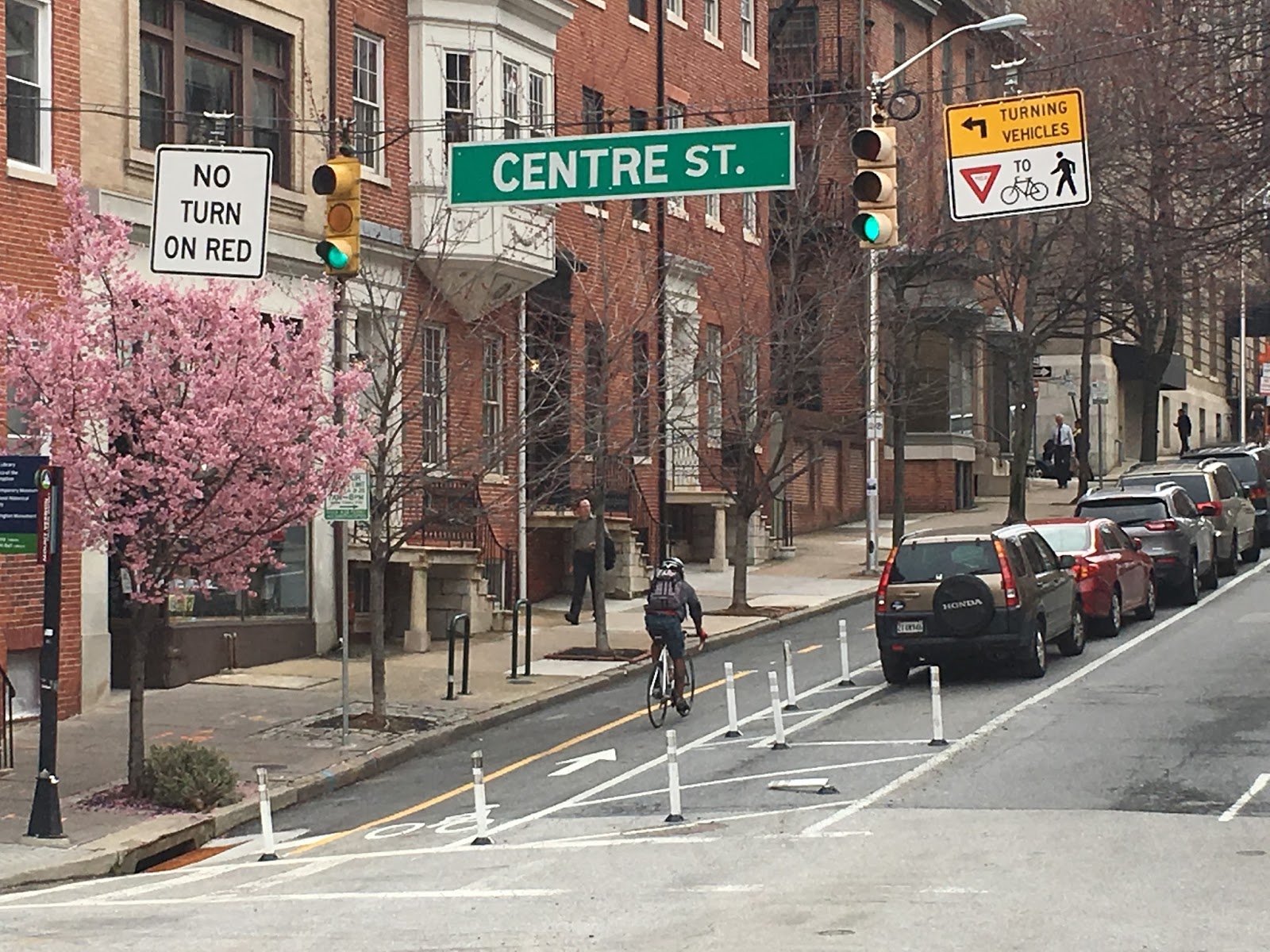
As an urban designer, I am concerned about the tendency of traffic engineers to relegate each user into a strictly delineated space, possibly painted in its own color. Green boxes for bikes, red lanes for buses, space above the curb for pedestrians etc., all separated with flex posts, barrels and barriers spread all over the place. All in the name of complete streets.

While those tools may be necessary for a while, they not only make the street very messy as a public space, they also encourage the self-righteous behavior that is all too common among users of the street. Bicyclists yelling at car drivers and back when the various "modes" get into each other's spaces. Contrary to the saying, fences do NOT make good neighbors. The insistence of the rights that come with a green light, a lane or a crosswalk often create unnecessary tension, frustration, hostility, aggression and increase risk. Those measures and tools just deepen the idea that pedestrians and bicyclists, to name just two groups, don't belong anywhere except into their designated spaces.
Maryland Avenue-Liberty Street cycle track: Lots of sticks and lines

It is precisely this attitude that causes crashes. It allows drivers to zip with 50mph along a series of green lights  and mow down any pedestrian that dares to step a foot off the curb at the wrong moment. These "absolute" rules also cause frustration because they are rigid and don't align situationally. What we get is people running red lights as pedestrians, bicyclists and even drivers when there is a sense that the red light has no purpose, for example when the cross street is devoid of traffic.
Love is not a Subaru

There are incremental solutions to this problem such as traffic circles or four way stops, both yield surprisingly high and safe through-puts and require a certain amount of "negotiation", a reason why some people hate them. Downtown San Diego has replaced many signals with four way stop signs even on big streets slowing people down without causing congestion.

A step further is the concept of "naked streets" (don't Google it without adding the word design!), i.e. streets that have been cleared of all the clutter of regulatory signs and installations. In those shared surfaces the boundaries are fluid, "right-of-way" exists neither figuratively nor legally. Who goes first has to be negotiated through common sense and collaboration. It requires slow speeds and full attention. This may sound delusional considering what is happening on Baltimore's streets, but experiments around the world have shown that the concept works safely and efficiently even in high volume urban areas with the complexity of a multi leg intersection. Typically crash rates have not only gone down but also become much less severe once the rigid rules were removed.

Naked streets could become quite realistic with the automated vehicle that is designed to respond to its surroundings without human error. It is precisely the unacceptable current conditions on our streets that requires out-of the box-thinking that sees the street as part of the urban environment that has to do its part to create the high quality of life that is key to attracting and keeping residents in Baltimore City.
"Naked Street example Graz, Austria

Liz Cornish demanded that urban streets should be designed so they never tempt people to drive faster than 30mph, a speed where a pedestrian has a chance to survive, even after getting hit by a vehicle.

Clearly, streets designed to go 50mph will induce those speeds, no matter whether lower speed limits are posted. But even more important, only if streets are seen as spaces where community happens and where it is a pleasure to live alongside, will streets ever become "complete". Such a shift doesn't have to take forever.
Act Now! Implementing projects quickly and using low-cost materials helps inform public decision making. Cities across the U.S. have begun using a phased approach to major redesigns, where interim materials are used in the short term and later replaced by permanent materials once funding is available and the public has tested the design thoroughly. (NAACTO Design Principles)
Carving out space for people (NAACTO)
For those who wonder where the city would take the money for such a reconstruction of streets and point to the long delayed Maryland Avenue cycle track as a cautionary tale about the sluggishness in which streets would be transformed, there is tactical urbanism: The technique made popular by Jan Gehl Architects in Copenhagen and also by Janette Sadik Khan who painted Times Square blue and blocked the cars out overnight. How about blocking off the leg of Light Street next to what used to be McKeldin Plaza when Light City 2017 rolls around? A grand experiment that can be reverted should the sky really fall. After all, the fountain was demolished to allow just that move. Let's just do it! Tactical urbanism, i.e quick, temporary low cost installations allows real life testing and assessment and immediate relief. It spends the money on action instead of studies.

If Complete Streets 2.0 gets it right, the policy could save the City lots of money. Instead of just striving for sheer quantity (how many miles of bike-lanes?), a policy that is focused on systems and networks (transit, pedestrian, bicycles, greenways, arteries) and is tied to the major city goals such as growing and retaining residents, providing more equity and a healthier and more sustainable environment can easily pinpoint where the gaps are. Zooming in on gaps and points where systems fail allows setting priorities in a qualitative approach that is much more cost effective than the raw quantitative one of current policies.

Klaus Philipsen, FAIA