Friday, August 27, 2021

How to stem the tide of Baltimore's population loss

The results of the 2020 census must be a wake-up call for Baltimore. Just like every previous decade before, Baltimore has been bleeding population once again. My friend Paul Sturm summarized the calamity in an opinion piece in the Sun this way:

Many of the stories about the new census data showing Baltimore City lost over 27,000 people (5.7% of its population) from 2010 to 2020 neglected to mention Baltimore is the only major city in the northeast corridor to see its population decrease over the past decade. Washington, D.C., Philadelphia, Boston and New York all gained residents during this period — ranging from a 5.1% increase in Philadelphia to 14.6% in Washington.

Even more troubling is Baltimore’s 30-year population trend compared to other major northeast cities — particularly Boston and Washington. In 1990, just over 736,000 people lived in Baltimore City while 574,000 lived in Boston and about 607,000 in Washington. But as Baltimore lost more than 150,000 people over the past 30 years, Boston gained 100,000 residents while Washington added nearly 110,000. Each city now has over 100,000 residents more than Baltimore.

I have long held the opinion that population growth is the closest to a silver bullet that Baltimore has to offer. (see previous blog articles here and here). More people would add resources, avoid school closings, help retail and prevent our neighborhoods from falling into a cycle of decline. More demand would stabilize real estate values in declining neighborhoods and would help maintaining a qualified and versatile workforce. In all, maintaining Baltimore's population would make life of existing residents better, not worse.

Blue= Population gain, red =population loss.
The Black Butterfly and the White L in 
different colors
 By contrast, the ongoing shrinkage brings even higher concentrations of poverty, even lower demand for retail, it depopulates our schools even more and exacerbates the growing disparity between the the labor pool that is needed versus the one we have. All of this would further deprive existing residents of opportunity.  As such the discussion whether growth would serve or deprive existing residents is really moot and so is the discussion whether additional residents mean "gentrification". 

In a city that had been “built-out” by the 1950s in terms of its size and geographic boundaries, how many people move in or move out is at the root of many issues at the neighborhood level. Using this one measure (the change in total population at the neighborhood level over two points in time) can help everyone better understand the interconnected set of issues and experience residents, businesses, and other stakeholders are having. (Baltimore Neighborhood Indicator Alliance)
BNIA's map published shortly after the latest census indicated the renewed staggering losses that Baltimore incurred. The map  also shows  that the losses are not at all evenly spread. Instead they follow the by now well known pattern of the "black butterfly" and the "white L", terms coined by Lawrence Brown, a former Morgan State University professor, describing the poor, disinvested and almost 100% African American communities in East and West Baltimore in the shape of two butterfly wings and the thriving center area spreading east along the waterfront which is often majority white. Brown also publishes the annual Baltimore Apartheid Syllabus. As BNIA's Professor Colin Starger referring to Brown's maps and terms illustrates in this video, the pattern of the maps is pervasive across many indicators and data sets that the BNIA institute has compiled. Starger explains the correlations the maps illustrate.
"And yet, you can see that the same basic pattern is repeating itself over and over to me. And I have to say, that as a visual thinker, this is a powerful indictment of structural racism. And it is a powerful indictment that is rooted completely in data that has been verified by BNIA and is open source and available to the entire world.
And we can see that you're not going to be able to solve one problem unless you grasp this whole situation. Unless you understand that everything is related and the type of hypersegregation that Dr. Brown is talking about isn't just a product of one simple system.
And it's not just the product of intentional discrimination. Rather, it's the product of a system that just kind of has a lot of inertia, doesn't care, and advantages some people and disadvantages some people, and has all sorts of implicit biases built in."

 Clearly, population loss is most concentrated in the most disinvested communities of east and west Baltimore.  And yet, the answer can't simply be to pump lots of money into these areas and growth will follow.

The plight of deeply disinvested areas is not new, nor is the desire to do something about it.  The debate about the best way was exemplified by the different positions that Mayor Schmoke and later his successor  Mayor O’Malley took. For example: "Working from greatest need" was Schmoke's approach, "working from strength" was O’Malley's with theoretical support from Paul Brophy. Based on biggest need, Kurt Schmoke and developer Jim Rouse tried to rebuild Sandtown together, not from the top down but based on community support and the BUILD coalition. My firm and I were a small part in the rebuilding Sandtown effort after 1992. We all know what happened: The Sandtown dream died, not for lack of effort or will, but for lack of the resources needed to work against the market and the tide of  ongoing urban flight. After Freddie Gray died Sandtown became a symbol of failure all across the world. Today the problems in Baltimore's deeply disinvested areas are much bigger, not smaller than then. 

"You can’t push the rope", Bill Struever, a developer  with ties to then Mayor O'Malley used to say. O’Malley using his "working from strength" approach wanted to invest in east Baltimore using Johns Hopkins as the anchor of strength which would fuel the revitalization effort in the Middle East community now known as EBDI. O'Malley never developed a specific growth strategy for Baltimore. His time is now mostly remembered for his "broken windows" approach to crime and the mass incarceration that followed. Middle East was largely depleted of its original residents, dislocation was as  massive as the investments making the successes of this east side development still suspicious to many.

Still, working from strength continues to this day to be the strategy Baltimore's Planning department and its Director, Chris Ryer,  lack of resources is still the deciding factor. Five  “impact investment areas” were identified under mayor Pugh, they did not include Sandtown. The brochure has since been modified to include more areas. Ryer speaks a lot about “middle neighborhoods” communities that have not yet failed and which have somewhere near them elements of strength, a park or some anchor institutions. Asked in a 2019 interview by the American Planning Association about the Planning Department’s approach to community development in the city Ryer said this:

It’s what we would call a “middle neighborhood strategy”: neighborhoods that are not wealthy, not in good shape, but not highly distressed. Fifty percent of Baltimore’s population live in these middle neighborhoods —  not highly distressed, but not highly successful. They could go either way. This is where the community development world plays now, because they don't typically have the resources for the distressed neighborhoods. We know in middle neighborhoods, our target areas, there are certain corridors that matter a lot: Greenmount Avenue in Waverly or Pennsylvania Avenue or any arterial in middle neighborhoods. They’re typically a mixture of residential and commercial, one of which is not really functioning in the market. (APA)

The term goes back to a 2010 study "Great Neighborhoods Great City, Strategies for the 2010s," which followed the previous census and the hand wrining about population loss then. Data from the Baltimore Neighborhood Indicators Alliance at the University of Baltimore and the Department of Planning suggested a tri-part city: Neighborhoods that are stable and attractive (36 percent, now known as the "white L") "middle neighborhoods" which are stable but require attention to offset potential deterioration (35 percent) and those already seriously deteriorated (29 percent, now known as the "black butterfly"), places from where residents continue to leave.

Barclay is the showpiece of a turnaround community, it may have started as something less than a "middle neighborhood". But it worked from strength: Its strength was the Central Baltimore Partnership and the universities in it that helped to organize a strong community based and inclusive strategy. (I previously wrote about working from strength, Baltimore's neighborhood development and Barclay here). But Barclay is small, close to the "white L"  and it would take many many Barclays to eliminate the ills of the Black Butterfly. Many other middle neighborhoods are not part of the black butterfly configuration and sit further out along Perring Parkway or the Liberty Road corridor, for example.

Looking at the latest census and BNIA's map, the"middle neighborhoods" would be orange or yellow. One could say that it is less relevant to have the right analysis explaining the biggest population loss, but how a workable remedy can look like. 

As in COVID, in the end we don’t beat "the virus" with moral arguments or pointing to rights and the like, but by doing what is practical and what curbs the spread. Moral arguments won’t beat urban decay or the flight out of communities that have been in decline for decades. Instead, how to leverage available resources most effectivley to prevent people from leaving where smaller investments can make a critical difference. Sandtown, Harlem Park and large parts of Park Heights offer a glorious past and some really tough residents that are wonderful community organizers. But turning these communities  or the vast areas north of the Amtrak "piano" in east Baltimore around requires  nothing less than federal and State reparations in the billions of dollars.  

In sum, building from strength in an incremental but systematic way has no practical alternative, unless there would be a giant policy shift, for example, the payment of reparations. And then there are the overall quality of life issues in the city, crime, schools and transportation, all three are recognized but only the schools improvement program is funded and on a somewhat solid footing.

That gets us get back to Paul Sturm's commentary. He points out that one giant difference to the cities to which he compares Baltimore is transit, or in Baltimore's case, the lack thereof.  Sturm references various studies which point to the link between poor access and mobility and poverty and the continues:

The research of the University of Baltimore’s Baltimore Neighborhood Indicators Alliance comes to a similar conclusion. “The impact on urban neighborhoods of long commute times is highly detrimental to population growth,” the Alliance says in a 2016 report.

More data about the impact of unreliable public transit in Baltimore comes from the Baltimore Collegetown Network. In its 2018 survey of students at 16 schools, only 36% said they were “definitely or likely” to remain in Baltimore after college, with “Better Transportation” cited as the most frequent response to “What is Baltimore missing that you wish it had?”

The prospects of Baltimore getting better transit are not rosy, the talk about reviving the Red Line notwithstanding. However, the Biden administration and the possible infrastructure packages represent opportunities which Baltimore must use. Good reliable access to jobs and opportunities for those without the ability to drive is a must for any city; alone climate change dictates it. 

With each decade the lift of stemming the tide of flight out of Baltimore is getting bigger and harder. Time to get it done. 

Klaus Philipsen, FAIA

Updated with a more succinct summary 8/28/21

Improving public transportation is key to reversing Baltimore’s population loss | COMMENTARY

At the Patapsco Light Rail Station, riders can connect between the light rail line and buses. The Maryland General Assembly will take up the proposed Transit Safety and Investment Act this session. Jan 11, 2021. p2
At the Patapsco Light Rail Station, riders can connect between the light rail line and buses. The Maryland General Assembly will take up the proposed Transit Safety and Investment Act this session. Jan 11, 2021. p2 (Amy Davis)

Find SUN the op-ed here.


Paul Sturm (psturm@outlook.com) is Chair of the Downtown Residents Advocacy Network

Thursday, July 8, 2021

How the failed Security Square Mall could become a thriving town center

 Death by a thousand cuts

Security Square Mall is one of the dying  malls that dot America from sea to shining sea. But while successful mixed use town center style redevelopments have become success stories and new economic engines, Security Square mall's decline is reaching levels that many had thought unimaginable a few years back, even when the vultures were already circling over the 90 some acres making up the mall. There are at least 3 creepy videos about the mall on YouTube. A recent petition to do something about this malls has garnered 800 signatures. The Reisterstown branch of the NAAPC is forming a working group to figure out what can and should be done. Mall owners fight each other in court.

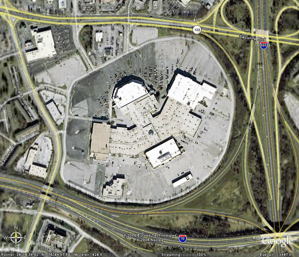
Security Square Mall: "The  eagle has landed", an isolated, winged object
in the landscape (Google Earth)

The 1 million square foot mall was built in 1972, a winged structure surrounded by a vast sea of asphalt. By comparison: All of historic Fells Point in Baltimore  is comprised of only 75 acres and has 15,000 residents, the new HarborPoint development in Baltimore City rising where the former Allied Signal plant once sat is only 26 acres large, but is planned for 3.0 million sf of development. In short, the 90 acres of the mall represent a very poor use of land.

The mall has been dying when Montgomery Ward became a Seoul Plaza, and when that gave way to a bunch of Asian themed small stores, , and a husband and wife church called "Set the Captives Free" and when Montgomery Wards became a truck driving school.  It died when Sears closed in October 2019, when Old Navy left, when Hechts became Macy's and Macy's tumbled from one reorganization to the next. Today the only recognizable retail names left are Macy's and Burlington. 

COVID has given the dying mall another blow, and yet, the emaciated mall is still pretending to be a viable destination. Still,  there is no practical plan for the future, not even an official vision.

Historically, shopping malls have been isolated, single-use developments that
stand apart from the community. Their exterior presence is typically monolithic
and overscaled, with blank architectural forms that are oriented inward—toward
vast, climate-controlled shopping arcades—and that turn their backs on surrounding neighborhoods. Parking structures and lots accentuate this effect, creating a concrete moat that limits accessibility from beyond the site, except by automobile, and separates the mall from community life. In the 1950s, this was the brave new world of shopping; in the 2000s, it is an anachronism, an artifact of a world that no longer exists. (ULI Mall Paper)


Feuding owners

A sea of asphalt around an empty burg: Security Square Mall
(Photo Philipsen)
Things are so dire that  a witness in the Board of Appeals Case No. CBA-21-008 testified that a recent fire in the vacant former Sears area could not be quickly extinguished, because the successor company couldn't be reached and the firemen had to break in to get to the flames.

The legal case sheds a light on the reasons why no progress has been made with this mall. There are five different owners with very different outlooks.  The owners don't pull in the same direction, more accurately, they are at each others throat. 

The Board of Appeals case is based on one owner wanting to build a "pad use" in form of a WaWa convenience store and gas station and had filed this project under a "planned shopping center" designation which Baltimore County approved, even though this lowest tier development would be the last thing that is needed here. Blocking the edges of the mall property with additional auto oriented uses would cement that status quo as an island and stifle creative, comprehensive new development.

A Greek inspired failing shopping temple
(Photo Philipsen)
Another mall owner, Howard Brown, who developed the Owings Mills Metro Center, filed an appeal to revoke the designation as planned shopping center.  His lawyers argued this designation isn't applicable to this mall. The verdict is still out. 

Howard Brown himself has obtained development approval for two office buildings on the mall property, which would also present an obstacle for a comprehensive redevelopment in conflict with Brown's other idea of turning the ailing mall into a  vibrant town center. At least that is what he announced publicly in a full throated community meeting on a Wednesday night in March of 2017 in Woodlawn, where Councilman Quirk had introduced the developer as a "truly transformative" force. (I wrote about this here). 

"As in most malls, it's time [for it] to be scrapped and it's time to come up with a new concept. You don't have anything in this area. You have suburban apartments, you have retail strips but you don't have an urban center which encompasses all of it. Macy's will probably close soon and then Sears will probably follow and then the mall is done.... Time to start a new concept...Retail is dead after 9pm, mixed use town-centers have life 24/7" (Howard Brown at the Woodlawn community meeting and as quoted in the SUN).

Brown then also predicted "five years of litigation" but suggested, he would be the winner and come out as the "master developer" for the suggested urban redevelopment that would look "as if it was 

The spooky interior of what used to be the JC Penny store (Mall video)
downtown Baltimore City, [but] located in Baltimore County".  Since then over four years have passed and an end of litigation is not in sight. No further refinements of Brown's redevelopment ideas came to light either.

Mall to mixed use town center: An old hat by now

The idea of scrapping ailing malls and department store studded shopping centers and replacing them with urban, walkable, high density, mixed-use" developments has been realized all across America. These re-developments create "traditional" town-centers with streets, sidewalks and storefronts and restaurants lining a grid of streets interspersed with small open air activity spaces.

Good examples can be found near Washington, for example at Rockville Mall (which was converted to Pike and Rose) and the White Flint conversions in Montgomery County, and on Metro Stations in Arlington County, such as Clarendon

A high intensity "transit oriented development (TOD) had also been the assumption when the Red Line had been designed to terminate in the Social Security Square area, before this rail transit line was killed  by Governor Hogan in 2015. 

Rockville Mall, now Pike and Rose (Photo Philipsen)

Several malls in the Washington area, such as Tysons Galleria and Pentagon City were already conceived in a more urban form from the start and have been substantially upgraded and revised in recent years. 

The issue of dying malls has been so pervasive for so long that as early as 2005 the Urban Land Institute (ULI) convened a high powered expert group  and developed "Ten Principles for Rethinking the Mall". Those princop[les are still applicable today and should be considered when it comes to Security Square Mall:


  1. Grab Your Opportunities or They Will Pass You By
  2. Broaden Your Field of Vision
  3. Unlock the Value of the Land
  4. Let the Market Be Your Guide
  5. Create Consensus
  6. Think Holistically Before Planning the Parts
  7. Connect All the Dots
  8. Design Parking as More Than a Ratio
  9. Deliver a Sense of Community
  10. Stay Alert, Because the Job Is Never Done


Why the future of this land is so vital for the County

The question of hulking Security Square Mall is no trifle matter for the future of the western part of Baltimore County. which in this area is a fairly narrow section hemmed in between Patapsco State Park and Baltimore City, bifurcated by the Beltway.  Many of the county neighborhoods in this western and southwestern area fall into the category of "inner ring suburbs", a planner term for the older suburbs which tend to have been overlooked by investment and subsequently have taken on some of the demographic and economic dynamics of the neighboring core city.

A 2007 sketch showing how the Security Square Mall area could have a
street grid and be a towncenter (ZGF Architects)
"Inner ring" downward trends can include sinking population, higher crime, low performing schools, lower home values, and lack of quality retail. 

These threats have been recognized for some time. Years back the County created revitalization districts  and some serious efforts were made to revive historic "streetcar villages"  such as Catonsville and make them attractive destinations. While the restaurant and music scene in Catonsville has become a success story, and Pikesville offers some attractive retail such as a Borders Bookstore and a Trader Joe's grocery, most westside residents have to do their shopping  for clothes, appliances or quality home accessories in rather distant places such as Columbia, Harbor East or Towson. 

Meanwhile county homebuilders and developers are complaining that they are running out of space to build. A 90 acre dense redevelopment could allow millions of square feet that wouldn't have to happen  on the few remaining farm-fields or in forests inside the urban-rural demarcation line (URDL). In fact, the redevelopment of Security Square Mall into a dense urban center would fit nicely with the original concept of vibrant new town centers which had been conceived when the URDL was first created. White Marsh, Owings Mills and originally also Security Square were the place where development was supoosed to be concentrated in order to save the farms and fields outside the URDL

2007 sketch how a new town center could look as seen from Security Blvd
(ZGF Architects)

But real town centers  don't happen by just waiting for them. They take active planning as the ULI case study of mall redevelopment clearly postulates:

One clear insight that comes from these case studies is the vital role of the local (state, county, or city) government in leading the repurposing effort to
bring back economic activity in the area. The cities and counties in these
case studies have provided public support through infrastructure, financial incentives, and streamlining the process for investors. 

The Security Square mall area is extremely well connected, even though access to I-70 is somewhat cumbersome. It is also a transit hub with several bus routes terminating on the mall area itself. Higher density here would not overwhelm roads or transit, nor would it remove any valuable forest or open spaces. Compact new development would actually improve the enormous storm-water run-off that the totally sealed off area creates today. Just as Clarendon in Arlington County shows, high density development of apartments over top of retail, restaurants and entertainment  could taper down at the edges, so it wouldn't overpower the surrounding low density residential areas. As in Clarendon, the development could surround a public plaza or small park in which events could take place, picnic and outdoor eating in the summer, ice skating in the winter. 

Target, Whole Foods and several other "big box" retailers have developed urban versions of their standard suburban boxy stores, examples  can be seen at the Whole Foods at Harbor East, in Columbia, the Target at Columbia Heights in DC and many other places around the country which feature lower level parking and sometimes two story or upper level stores which can be reached via sloped step-less "escalators" that allow shopping carts to be moved between the levels. In that form even those stores could then be incorporated into a redevelopment.

How Security Square Mall is divided up into
separate properties (Board of Appeals exhibit)

A high density mixed use redevelopment of the 90 acre area of Security Square Mall could also incorporate all current owners as equity partners and provide opportunities for existing retailers to return. The new development would have so much more space to offer, that nobody would have to be displaced and pushed out, except for the truck driving school. 

Per the communities desire, the development could include a community outreach center or other public functions, such as a post office (as in the current mall). The redevelopment could offer housing of a variety that is usually not found in the County, except for Towson, including affordable and accessible housing units which are in extremely short supply in Baltimore County.  

In short, opening up several million square feet of development space would be a great economic development initiative. It would provide jobs during construction and operation, could give a boost to existing communities, create a new destination, offer attractive shopping and dining opportunities, and bolster the County tax coffers. Heck, coming so late to the party, this redevelopment could aim to outdo all those who came before and become a model in sustainability and equity, especially by incorporating local minority owned businesses, the best stormwater management practices, lush vegetation, attractive open spaces and net zero buildings that make their own energy through solar, geothermal or other renewable sources.


The role of government 

At least three past County Administrations missed to act on any of the ULI principles. When asked about Security Mall and its potential as a major transit oriented development during Red Line planning, the late County Executive Kamenetz pointed to the mall as a private matter. It's in the hands of all those owners not government's business he told me. 

Now with equity and climate change as the major agenda items being front and center for all local officials, shrugging the shoulders about the protracted legal mess at Security Square Mall is no longer an option. Nor should it be an option to bring urban mixed use development to the southwest of the County by using green spaces or low density single family housing as proposed by the Promenade development promoted by Whalen properties. That development doesn't have nearly the same connectivity and it would cannibalize the potential of the Security Mall redevelopment. 

The potential of the Security Square Mall property  won't be unlocked without pro-active government involvement, the hard work of achieving a consensus on the desired outcome, figuring out the development partners, the financing and the incentives and decisions needed to make it all work. 

White Flint Mall redevelopment rendering (website)

In many places these type of complex deals are achieved in public- private partnerships for risk sharing and a broader access to funding options. In the case of Owings Mills' Metro Center, the partnership included the State of Maryland and its MTA, the County and the private developer, Howard Brown. MTA owned the surface parking lots of the Metro station that were needed to build the center. Thus, the State offered the land and funded a garage that would replace the lost parking.  Brown built the mixed use structures and the County contributed a library and the Community College branch.

In such a partnership, the initial risk and financial investment is reduced and spread among each group, with the expectation that public investment in a major tenant like a college or library will attract additional mixed-use development. (Maryland Department of Planning)

The Washington area mall redevelopments are architecturally more interesting than Metro Center in Owings Mill. They offer a lot more retail because Metro Center is being cannibalized by two other large retail developments within a 2 mile radius (the old Mall redevelopment with big box retail and the redevelopment of the Solo Cup factory area). This case of uncoordinated an non synergistic investment about which I have written before here and here must be avoided in the southwest area. 

Security Square Mall represents a unique opportunity to get it right by learning from the best of what others did when mall redevelopment was still pioneer work. The promise of a win-win-win for the public, the current owners and the County should make everyone rush to the table. 

Baltimore County government can't sit back any longer just waiting for the mall owners to duke it out. Instead the feuding owners should be forced to come to the table, should they don't see the light by themselves. Options range from citations for all county code violations found on the 90 acres to a development moratorium and, ultimately, the nuclear option, condemnation, if and when life and safety of the public is in peril, as when the fire department couldn't locate an absentee landlord.

Klaus Philipsen, FAIA

The article was corrected for the sequence of changes of store is the mall. Montgomery Ward did not change into a JC Penny but turned into the truck driving school and other uses. 

Friday, June 4, 2021

Can the scars of the "Highway to Nowhere" be healed?

There are brief moments in history where everything seems possible. With Biden's gigantic plans for infrastructure and recovery even fixing the "Highway to Nowhere" seems to be a possibility.  This monstrosity of past urban planning and transportation (see original plans here) elicited so far only mild interest since its completion, not because its injustice and negative effect on the surrounding communities weren't blatantly obvious, but because undoing it seemed utterly impossible in a City plagued by needs that always exceed its resources many times over. 

Account of dwelling units destroyed by highway alternatives (1960): The highest 
number is indicated for the only segment that was built:
 1,313, dwellings, the majority in fair or good condition (Link)

But today is a different day: Big budget plans are being hatched inside the Washington Beltway and white America slowly begins to see that the country's inequities did not just happen due to some divine scheme, but that they were planned and intended and that transportation was just one of those tools. The Highway to Nowhere is no exception. 

Shrugging the shoulders in face of its ongoing impact, therefore, just continues the injustice and extends the guilt that comes with its creation to this day. I wrote about this highway on this blog under the title "the ultimate insult" in 2016. Since then the collective re-thinking has further progressed.

In "the ultimate insult" I described the road project this way:

That one piece of the [East-West] connection that got built is difficult to be identified as a part of a bigger undertaking, it is too isolated and disconnected, hence it is called the Highway to Nowhere. Because the other parts to the east or the west were never built, the built segment is utterly useless. 

Going nowhere fast: Wasted space, destroyed homes
(Photo: Philipsen)

Nevertheless it unfolded its full destructive potential by clearing out thousands of homes in its path, everything between the south side of Franklin Street to the north side of Mulberry Street was cleared from Pulaski Street to Paca Street, disconnecting the neighborhood of Harlem Park from those of Poppleton and Franklin Square and Midtown Edmondson neighborhood from Penrose. Robert Moses, a planner, authoritarian and, many say, also racist, saw an opportunity to "clean-up" the "slums". He supposedly said, "the more of them that are wiped out, the healthier Baltimore will be in the long run".

In 2021 the Highway to Nowhere is back in focus thanks to the federal Reconnecting Communities Act, and the Economic Justice Act with $435 billion “in immediate and long-term investments in communities of color to address systemic racism and reverse decades of historic underinvestment,” (Press release). Maryland officials have their eyes on this 1970s testament of failed transportation and want to remove Baltimore City’s “Highway to Nowhere,” the 1.3 miles of expressway that was built in the 1970s, cutting right through the densest part of West Baltimore, the only segment of a giant imagined network of freeways that was actually realized.

“We are fully committed to finally ending this long-standing monstrosity” Sen. Chris Van Hollen, D-Maryland.

“It’s never too late to undo the wrongs of the past.These used to be very vibrant communities, very close-knit communities”  Rep. Kweisi Mfume, D-District 7.

Sens. Ben Cardin and Van Hollen are co-sponsoring the Reconnecting Communities Act to target communities like West Baltimore separated by highways.

“They were built kind of with the mandate of going through the cheapest land possible,it really bisected—it separated—a neighborhood, a very vibrant neighborhood at the time.” Dr. Celeste Chavis of Morgan State University. 

“The highway to nowhere is the poster child for inequality and systematic racism in our country,” Mayor Brandon Scott.

 The sunken highway with its six 1.3. long freeway lanes and a median which was originally designated for a west extension of the Baltimore subway has elicited big ideas and much smaller actions for decades: 

  • Already, the western end of aborted ramps, retaining walls and bridges has been level to become additional parking for the MARC commuter station. 
  • Already the City used the median strip for a gigantic tree planting effort after the Red Line was choked off by Governor Hogan in 2015, an act that many see as another symbol of institutional racism in transportation.
    Tree planting in the median (Bluewater)


  • Caves Valley, owner of the Metro West Center at the east end of the freeway imagines the overpasses and ramps at Martin Luther King Boulevard to come down in favor of a normal urban intersection, freeing up a significant land area for development.
Other ideas floated over the years, are less practical or far more expensive:
  • Two 1.3 mile long murals painted onto the sometimes 30' tall concrete walls flanking the expressway (Sun article)
  • a 1.3 mile linear park imagined as a sunken inverse of the elevated New York "Highline" park. (ULI Report), Rodricks article)
  • a big linear lake
  • and a dirt-bike park (Sun letter)
  • A mixed use redevelopment with transit

All the ideas suffer from the fact that they are not born from the minds of the communities facing the Highway to Nowhere every day. Instead they are produced by students, artists and professionals who see the highway folly as a canvas to think big. In that, they approach the problem not very differently than Robert Moses once did, when he was involved in the early expressway planning stages that go as far back as 1948. 

ULI report: "Creating a beautiful boulevard"

For a true reconciliation project that undoes at least in part the historic and current injustice, whatever is done should help to undue the past damage. This means real physical connectivity from north to south far beyond the stark concrete bridges that span the "ditch" today. All the "linear" proposals" that do not overcome the deep cut going through the communities would just paint a scar with make-up, potentially deepening the separation. True healing would make the cut go away. 

Gerald Neily, "Baltimore Inner Space", mixed use and transit

Mayor Scott recently participated in a conference call of mayors speaking with Biden's new Transportation Secretary Buttigieg. Scott told the BBJ:

The right way to do this is to right the wrong without further displacing a Black community, without further ignoring what they want (BBJ)

One way to reverse displacement is to recover the lost space by filling the giant gash. 

This would be a gigantic effort with a staggering price tag, were it not for one other gigantic project, also with a giant price tag, being imagined nearby. I am talking about the B&P tunnel replacing todays age old tunnel under West Baltimore with a repaired old tunnel and three new bores. Those new tunnel tubes would produce potentially enough dirt to fill the ditch and the "spoils" would come out right where today's MARC station is.

And while we are talking about the synergy between big projects, let's also hope that the Red Line could be revived. Hogan will leave office in 2 short years; couldn't a Red Line revival be in the offing along with the big infrastructure bills hatched in  Washington? After all, that project had been designed all the way to the details over 13 years with a price tag of more than $250 million for design!  Even if the ditch were filled, couldn't at least a tunnel space be left, through which to run future transit?

West Baltimore communities started conveningearlier this year to discuss West Baltimore's future (The grass roots effort is for the West Baltimore Masterplan. This should be the place to put the Highway to Nowhere on the agenda and to come up with a plan that addresses the past injustices, the current needs and the future potential of this big scar that put West Baltimore on the decline. Time to reverse this trajectory!

Klaus Philipsen, FAIA

www.kphilipsen.com  - All my blogs in one place!

Previous articles about the Highway to Nowhere:

A detailed report about the Baltimore freeway battle can be found at Raymond Mohl's account or in the document "The Baltimore Interstate Highway System by UM
 Professor Garrett Power.
Andrew Giguere Thesis,  College of Arts and Sciences of Ohio University, 2009

See also on Community Architect From Displacement to Opportunity: Overcoming US Highway Injustices

Monday, May 24, 2021

Land Use shenanigans in Baltimore County

Baltimore City and Baltimore County are "joined by the hip", even if a look at the map looks more like the County has a vice grip on the City. Whatever the case may be, I have frequently reported about the interdependencies. Both jurisdictions have started their 10 year masterplan process under MD law and now with equity, inclusion, social justice and climate change on almost everybody's radar, it is more urgent than ever that development and land use planning are transparent, sustainable and inclusive. County Executive Johnny Olszewski  and Mayor Brandon Scott have both vowed to make local government more fair and transparent. 

A small recent development example in the County brought me out to testify at the Baltimore County Council as board president of a land trust along with executive director Barbara Hopkins. We both subsequently penned the below article to point out why those special side deals disguised as laws especially made for specific developers are not a good idea. The matter is not an isolated case but a persistent practice as one can see in this 14 year list of cases compiled by a community activist.

But first a flavor of the bill with the sections that show how much this bill makes its own law for only one single lot in the entire County.  This is what is stipulated in the bill:

Age-restricted single-family attached dwelling units, Subject to the following conditions and restrictions, are permitted:

·         On a development tract that is adjacent to the Honeygo overlay district if

·         Any portion of that tract is part of a planned 1 shopping center Approved prior to January 1, 2021:

A. Occupancy restricted:

(1) the owner of each unit is required to ensure That, at the time of any sale, conveyance, or lease of a unit, at Least one occupant is 55 years of age or older;

(2) persons under 18 years of age are prohibited from residing in the unit; and

(3) notwithstanding subparagraphs (1) and (2) the condominium association may permit persons between 18 and 55 years of age to reside in a unit if necessary to care for an occupant or to prevent an undue hardship.

B. The maximum residential density allowed on the Development tract shall be 16 dwelling units per acre and the residential development shall occupy a maximum of 4 gross acres of the development tract. 

C. Notwithstanding any regulation to the contrary, development of a tract under this subsection shall be

Governed by the following bulk and area regulations:

(1)   residential development is exempt from any front, side, or rear setbacks or any setback from the center line of any street;

(2)   Development of property under § 259.9.a.6 shall 

(3)   Not be considered to be located within the H overlay district, shall not be subject to any other standards or design guidelines outlined in this section, shall satisfy the requirements of § 32-6-108 of the Baltimore county code by paying a fee in lieu consistent with the fee that would be imposed on an elderly housing facility, and shall be exempt from the requirements of §§ 32-6-108 and § 32-6-111 of the Baltimore county code.


Why Even a Consensus Plan Shouldn't Circumvent the Law

By Klaus Philipsen, FAIA, Board President and Barbara L. Hopkins, Esq., ASLA, Executive Director 

It is a good thing when community members, a developer and a councilman come together to find consensus on development, especially when the agreement includes hard-core, anti-development neighbors. It is also good to replace additional strip commercial development with much needed housing. This is, in part, what happened when the Southern Land Company, and representatives of the surrounding communities, agreed on a plan for a 1.49-acre parcel on the Southeast corner of Belair Rd. and Honeygo Blvd. in Perry Hall.  It was not surprising, then, that Councilman Marks presented the outcome as a success in the County Council work session this last Tuesday.

What is not good, is when such a consensus gets cast into a Council bill and eliminates all the land use regulations, zoning, and required offset fees, which are in place to protect the public, to benefit a single piece of land and a single developer.

When NeighborSpace spoke out against Bill 46-21 and the compendium Resolution 67-21, we were cast as outside interlopers who rained on the parade at the last minute. (In point of fact, no one involved in the nine months of consensus-building ever mentioned the discussions to us. We found out owing to our practice of reviewing the Council website regularly).

To understand why NeighborSpace took the risk of being seen as the skunk at the garden party, it is necessary to understand a few basic facts about development:

  • Practically all the land in Baltimore County is subject to zoning;
  • When somebody doesn’t like the zoning, a rezoning application can be filed every four years;
  • If rezoning somehow doesn’t fit the bill, one can apply for a planned unit development that creates its own set of standards but has more oversight in the approval process; and
  • If one part of a lot should be commercial and the other residential (as in this case), one can also subdivide the land and rezone only one portion.

But none of this was done in this case. Instead, the Councilman introduced legislation that intends to create its own rules for this parcel, a result that should give us all pause. Here’s why:

WHAT DOES THE LEGISLATION DO & WHY SHOULD WE CARE?

The bill and resolution are symptoms of a systemic disease that has plagued the County for decades, becoming the bane of residents and developers alike. The disease is called “ad hoc lawmaking,” legislating for a limited purpose without regard for the contents of comprehensive and community plans, for established zoning rules, and for other important provisions based in federal Constitutional law that are there to protect the public from the adverse impacts of development.

For other symptoms, one need only look as far as the County Code and the Zoning Code. They have been rendered so impenetrable and obtuse by these long-standing practices that only their drafters, aided in no small way by legions of developers’ attorneys, can understand them. And the whole process perpetuates itself, year upon year, owing to the unfortunate principle known as “Councilmanic Courtesy,” which, translated, means “I won’t question your zoning bills if you don’t question mine.”

Because the disease is systemic, moreover, its impacts are far-reaching and they are very harmful, so much so that the patient is now on life support. That’s what led us to speak out against the legislation last week, offering the following reasons why we hope that other council members and our loyal readers will realize that it is not in their interests to sit idly by while this legislation heads toward passage:

1. The Legislation is Likely Illegal

There is a strong case to be made that the legislation could be rejected should it be challenged in court because it is unlawful “spot” or “contract” zoning, an agreement between the developer and the zoning authority (the County Council), which is illegal, because, among other things, it grants the property owner a special privilege not available to others and interferes with the government’s exercise of its police powers, a case we will definitely make in the paragraphs that follow.

2. If It Passes, the Legislation Will Set Legal Precedent for What Could Happen in Your Neighborhood

If this bill and resolution become law, they set legal precedent, establishing that it is okay for the County Council to take the Executive Branch out of its traditional review role and to set aside rules requiring developers to pay their fair share of the costs of development. The end result is that existing taxpayers are left to pick up the tab and developers and their attorneys are invited to employ these same tactics in your community.

3. The Legislation Represents Really Bad Public Policy

By "legislative fiat", the review process that is in place to protect the public from the adverse consequences of development, along with the requirement that developers pay their fair share of the costs of open space and schools, are taken out of play, cast aside like yesterday’s news.  Simultaneously, development standards designed to control land use and spur commercial development are watered down. Let’s look at each of these issues in turn.

A. Exemption from Development Review

The bill exempts the project from the traditional development review process, which requires the submission of plans to the County and several levels of review and public comment, and instead requires approval by way of what is known as a “limited exemption” under Section 32-4-106(B)(2) of the County Code.  

The scale of this project (and its deviation from the approved development plan) far exceed what is typically reviewed as a limited exemption, such as the construction of one, single-family dwelling or the building of an accessory structure like a garage. There are good, sound public policy reasons for review by qualified members of municipal agencies. That is a proper exercise of a government’s federal, Constitutional police powers, long-standing authority to protect the public from the adverse impacts of development, and we should be incensed and deeply troubled when such review is set aside so cavalierly!

B. Exemption from Contributing to the Cost of Public Facilities

Bill 46-21 exempts the project from complying with County open space requirements under Section 32-6-108 of the County Code and also from paying impact fees under Section 32-6-111.  Like the requirement for review, these provisions have a similar legal and Constitutional basis designed to protect the public from the adverse impacts of development.  When you look at Perry Hall, moreover, you find examples of the very problems these laws were designed to address. Let us explain.

(1) Setting Aside the Open Space Requirement

At the Work Session testimony was offered that setting aside the open space requirement is warranted because there are four parks nearby.  We learned, moreover, that the developer has agreed to make his project more attractive by installing benches, sidewalks, fire pits, dog stations and grills, and also to provide a $15,000 contribution to Angel Park.

Developers making their own development more attractive should never count as providing open space or paying related fees so that open space can be provided elsewhere. Even in Perry Hall where there are several parks, moreover, access to them other than by car is still a problem. The website “walksore.com” gives the area an overall walk score of 28, a rating that means “car dependent.” Development plans should never forget that more than half the population lacks the ability to drive because they are too young, too old, too poor, too impaired or otherwise have no car readily available to them.

But these rebuttals really only scratch the surface of what is wrong with setting aside the open space requirement. The real problem is that, because open space is a very pressing problem inside the County’s older communities (i.e., inside the Urban Rural Demarcation Line (URDL)), current law requires the developer to provide open space or pay a fee to the County. (In the interest of full disclosure, 20 percent of the fees collected come to NeighborSpace). Eighty percent of the fees collected go to the Department of Recreation and Parks and it is incumbent upon it to use that fee for open space within the Councilmanic District. And in spite of the testimony offered at the work session, there are plenty of open space needs in the district.  The map below, which comes from the NeighborSpace GIS model, shows where the protection of open space should be prioritized (darkest purple+ highest priority) to create positive social, economic, and environmental livability outcomes, by, for example, providing recreational space, buffering streams, and improving property values. The needs are myriad. 

Benches, sidewalks, and fire pits are not open space. Moreover, existing law should determine the fee, not the developer and the Councilman, and the Department of Recreation and Parks should be permitted to decide how that fee is used to address the many livability challenges shown in the map below.

(2) Setting Aside Impact Fees

Section 32-6-111 of the County Code requires new residential development to pay its proportionate fair share of the costs for land, capital, facilities, and other expenses necessary to accommodate development impacts on infrastructure and public school and public safety facilities. Let us not forget what led to this provision in our law, enacted just a few short years ago. The County was facing a dire budget situation, particularly when it comes to paying for the renovation and construction of its schools.  In fact, the school overcrowding situation in Perry Hall is what led to the instant proposal for age-restricted housing. How little sense it makes then, to turn around and exempt this project from paying impact fees.

C. The Watering Down of Legal Standards

Resolution 67-21 creates a Commercial Revitalization District on the site. It is hard to see how “revitalization” applies to a largely undeveloped plot of land. The Resolution doesn’t clarify this except to say that “the County Council finds that there exists a need for assistance to the property owners and businesses in the aforementioned area in order to stimulate public and private investment and renewed interest from surrounding residents and others in the community.”

As the County website and the program brochure for Revitalization Districts show,  the program is targeting the often failing older commercial corridors, never a single corner property or largely vacant, unbuilt land, as is the case here. In spite of the fact that the program is managed by the Planning Department, there was no testimony offered by the Department in favor of this new district to which it will be required to dedicate a planner. Should the resolution be approved, moreover, the developer will be eligible to apply for a five-year and possibly even a ten-year credit against property taxes. There are sound public policy reasons for providing tax benefits to developers that revitalize older commercial corridors like those shown in the map below, left. But no evidence has been mustered to suggest that the southeast corner of Belair Rd. and Honeygo Boulevard, shown in the map below, right, is one of them.

WHAT CAN YOU DO?

What happened here is not an isolated case.

None of this will change unless citizens hold their elected officials accountable. 


Klaus Philipsen, FAIA

Note: The strike-out portion of the bill regarding the open space regulation occurred as an amendment  after an initial protest.