Monday, December 27, 2021

Old Town Baltimore - an unkind mirror of Baltimore's planning history

It is hard to imagine a place where desolation, abandonment and plain waste of space is more in your face than at Baltimore's Old Town, a place that has seen nothing but handwringing for the last 30 years or so with few plausible explanations why things are as bad as they are. 
While we will investigate the trouble (see also my 2016 blog article), inserted quotes from recent decades show how protracted the problems are.
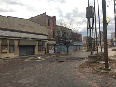
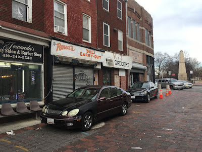
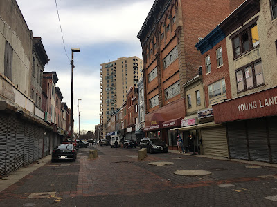
Old Town Mall today: Absolute desolation (Photo: Philipsen)
On a typical day, there's nobody inside Bernie Delay's little tailor shop on Old Town Mall. No patrons. No tailor. Sprawled on a folding chair outside, waiting for business and hoping for a breeze, he comes up empty. "There's nothing doing," he says with an old man's sigh.
Old Town - a walking mall lined with weedy lots, careworn stores, Civil War-era architecture and disco-era renovations - stands frozen. Caught between Baltimore's best efforts at urban renewal, long waves of municipal neglect and the mirage of redevelopment proposals that loom just out of reach, it is a place where business owners and neighbors wait for change and wonder why. Why does the nation's first inner-city neighborhood mall - which placed Baltimore on the map for urban planners in 1975 - stands a near-ghost town today?(Baltimore SUN, July 21, 2003)

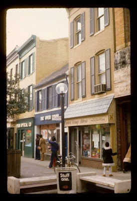
Old Town in its first years: A lovely Main Street

None of the many articles published about Old Town give really good reasons why an area so close to downtown, so close to Johns Hopkins Hospital, so close to Little Italy, Albemarle Square and so steeped in history should fall so far from its few years of glory after "the mall" was established in response to the 1968 riots as one of those then trendy pedestrian shopping streets which have since abolished in the US but are still common place in most all European cities.
Jesse Collins counts on 6-inch-long curled red fingernails the reasons she thinks the mall fell into ruin: Indifference. Politics. Racism. Greed. "If this was not a black mall, it would never have gone down the way it is," she says. "I'm like Forrest Gump: That's all I have to say about that." (Baltimore SUN July 21,2003)
No place in Baltimore is steeped more deeply in history. Oldtown is generally part of Jonestown (although it is not part of the Jonestown historic CHAP district), the oldest neighborhood in Baltimore, full with historic sites and stories, including the 175 years of the Lloyd Street Synagogue. Jonestown goes back to 1661 when an English settler, David Jones, made his home here.
The history of Oldtown Mall is depressing. Riots, looting, fires and a long-stalled development plan. One of the big property owners, Stanley Zarden, told me back in 1999, "Everybody that is here should get a medal."
I returned to Oldtown Mall, a pedestrian thoroughfare off East Monument Street in East Baltimore, yesterday after the owner of a Chinese carryout, Tien Zin Wang, was shot Saturday night while delivering $20 of food to what turned out to be a fake address on nearby Webb Court. (Baltimore SUN Jan 7, 2009)

When the region’s first European settler, the Englishman David Jones, built a house on the east bank of the stream that would later take his name, the Jones Falls, he laid the groundwork for a competitive relationship between Baltimore Town on the west side of the stream founded in 1729 and the emerging rival Jonestown to the east laid out in 1732. Eventually the Gay Street bridge created the link which allowed a merger in 1745. Jones Town became commonly known as “Old Town” a name that would resurface 200 years later. in 1813 the current Old Town Mall area was the site of one of Baltimore's public markets, the Bel Air Market which was leveled in 2002 to create space for parking for a dreamed about grocery store. 

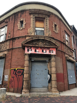
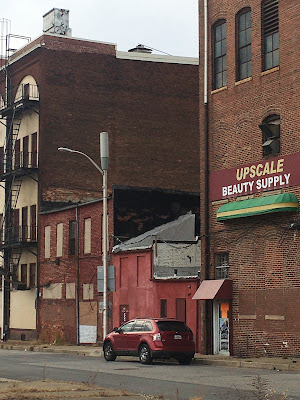
Old Town architecture: Eclectic mix (Photo: Philipsen)
Old Town Mall in East Baltimore is a centuries-old commercial district that has lived through periods of booming growth, recession and renewal. Once a shining example of urban revitalization, it has since largely fallen into disrepair, with more than half of the buildings standing vacant. (Baltimore SUN, Sept 27, 2012)
In spite of all this history, Old Town Baltimore has clearly not done as well as other historic neighborhoods such as Fells Point, Federal Hill, or Mount Vernon, to name just a few. Why?
The buildings themselves, though some are a little worse for wear, represent an impressive collection of historical architecture: Italianate Victorian storefronts; stout, turn-of-the-century commercial buildings; even a few diminutive two-and-a-half-story, dormered rowhouses from before the Civil War. If they were on the water or in Federal Hill, they would be filled with bistros, boutiques, and professional offices. But orphaned here in hardscrabble East Baltimore, they're dark and decaying. (City Paper, Oct 9, 2002)
The main reason, in my view, why those neighborhoods thrive is that the expressways originally designed in the 1950s and to be built in the 1960s, never materialized there. By contrast, Oldtown became the victim of two expressways: The pre-war Orleans Street viaduct of US 40 and the Jones Falls Expressway. Both landed just outside Old Town and recreated the old separation that originally stemmed from the stream. Although most historic roadway connections still exist under and next to the in part elevated freeways, in the minds of Baltimoreans the land under the freeways become "fly-over territory" and the places to the east became areas "far away from downtown", certainly no longer part of it. The fact that the street grid in this area has been challenging to begin with (for example with Gay Street as one of the rare diagonals) doesn't help. It is easy to get lost when one tries to get to Old Town.

Baltimore's planners and the city's Housing Department deepened the separation of downtown from the surrounding communities by arranging a number of large scale public housing projects like a ring around downtown. In many case these were high-rises that ignored the old city street grid and were plopped down as objects in modernist fashion, no relationship to streets. Most "projects" got blown up during the time of HOPE VI funding, some are still around, for example the Monument East high rise with its iconic round balcony cut outs. It sits just north of Old Town.
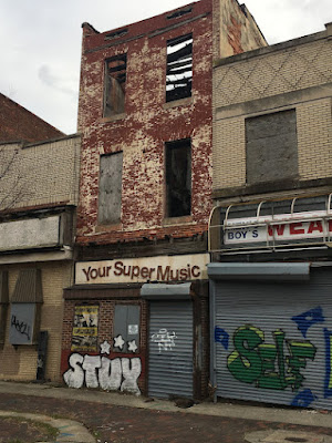
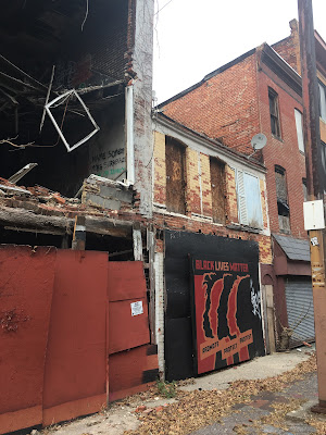
Stores shuttered for years (Photo Philipsen)


The low rise public housing projects of Perkins Homes Douglass Homes and Somerset Homes were around much longer. Once they came into play as well, new opportunities arose for the redevelopment of Old Town. (See my 2018 blog article explaining the overall project).
Some of Baltimore's most prominent developers have teamed up to work on the long-sought transformation of land near the city's historic and distressed Old Town Mall.
Beatty Development Group and Henson Development Co. are two of four firms behind a proposal to build a mixed-income community with rental and for-sale homes, a park, community center and a possible grocery store on roughly 16 acres in East Baltimore. (Baltimore SUN Feb 11, 2015)
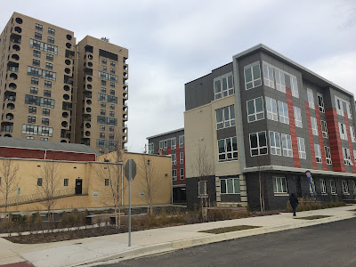
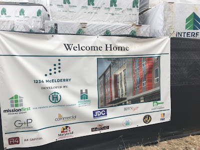
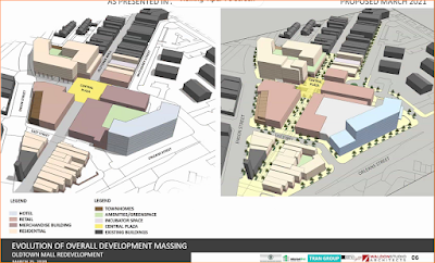
Now, six years after the latest development concepts were unveiled, the talk has moved to irrefutable action. The same Dan Henson who, as Housing Commissioner, had garnered record amounts of HOPE VI money to remove the housing highrises, some of which had provided the shoppers for the Old Town Mall. Now a developer, Henson has partnered with Beatty Development and others in a concerted effort of turning Perkins Homes, Douglas Homes and the former Somerset Homes area into a thriving new development. The approach is similar to the Flaghouse public housing redevelopment that has become Albemarle Square. Henson's first phase of mixed income redevelopment of the Somerset site, the McElderry apartments are now occupied. His plans for Old Town Mall have twice been reviewed by the city's design review panel UDAAP, in the latter version favorably.
Incredible: The north end of the mall has still active retail
(Photo: Philipsen)

The buildings, 64 in all, largely fall into three architectural categories: row house shops (mostly two stories with dormers) that date to the 1820s; Victorian stores, dating from the 1870s and wider and taller than the earlier rowhouse shops; and 20th century stores that emphasize Art Deco, Moderne and Sullivanesque styles. Some of the buildings are the last in the city to have cast iron fronts. The 500 block of Gay Street was closed to traffic in 1968 to create a pedestrian walkway that the city hoped would help business.(Baltimore Heritage)
It is too early to say if Old Town will really see the promised rebirth with all the bells and whistles shown on the plans. But the hundreds of completed apartments on the Somerset site are a good omen and they provide some of the demand that retail so urgently needs. On the other hand, retail's future is generally in question, and uncertainty about almost everything is what defines our time. Much could happen to derail even this most developed plan.
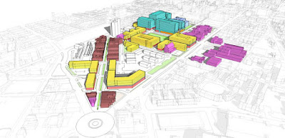
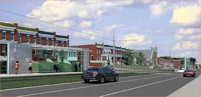
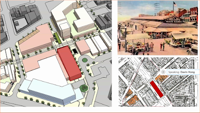
Beatty-Henson concept presentation 2016


The main cause of the decline of Jonestown and Old Town Mall, the JFX, is still in place. Lowering it south of Penn Station and converting it to an urban Boulevard is an idea that has been around for decades as well, yet nobody has yet collected the money for the realization of such a concept. For Old Town and the new Somerset to become an integral part of the City requires good connections on all sides. DPW traffic planners must go to work and see how better connectivity could be realized utilizing the complete streets concepts instead of the urban auto artery concept that is still prevailing here. This is a must-do compendium strategy if the massive redevelopment should become the success story that gives that part the Old Town part of Jonestown a new lease on life.

Klaus Philipsen, FAIA

The below photos are all taken by me in December and show the existing Old Town Mall conditions as well as the new phase 1 completed Somerset redevelopment as well as the phase under construction. The concept renderings were presented to UDAAP earlier in 2021. 


https://baltimoreheritage.org/issue/old-town-mall/ 

A very comprehensive City Paper article from 2002 can be found here. I am quoted in it as well  


Wednesday, December 15, 2021

RAISE: What can $50 million do for transit?

 When the US Secretary of transportation shows up for a press conference in Baltimore to announce a national grant, it is a fairly big deal for Baltimore. Flanked by the Mayor, the MTA Administrator, Council members, Senators and Delegates the pronouncements made at the press conference sounded as if this was the pivotal moment that would lift Baltimore transit out of the doldrums. 
Will this RAISE project deliver all the big promises? DOT
Secretary Buttigieg, MDOT Secretary Slater and MTA
Administrator Arnold at the grant announcement (Photo: SUN)


The reality is more modest. The federal grant is for $22 million under the Rebuilding American Infrastructure with Sustainability and Equity (RAISE)  program. The federal money will be matched by an $18 million investment from the Maryland  Department of Transportation (MDOT) and  $10 million from the Baltimore City Department of Transportation. (BCDOT). The award is for the infamous east-west corridor that emerged many times in Baltimore's history as a Baltimore transportation promise or failure. 

  • When it was designed as a super highway that (luckily) never became reality and ended with a whimper at the I-70 park and ride lot instead
  • when a short realized portion of the freeway, the "highway to nowhere destroyed thousands of homes and displaced their African American residents 
  • when a western metro extension, designed to go along the highway, never materialized 
  • when Governor Hogan killed the Red Line
  • when Obama's DOT Secretary Foxx came to Baltimore to denounce the inequitable impacts of urban freeways such as the Highway to Nowhere and promised funds for a fix
  • when a new Regional Transit Plan prepared under Hogan once again confirmed the corridor as a high priority for transit. 
    The Highway to Nowhere is part of the selected east west corridor
    (Photo: From MDOT application)


As for this RAISE grant, the corridor proposed for action reaches from Fox Ridge in Baltimore County on the east side to CMS in Baltimore County on the West side, traversing the entire City in between. That is about 20 miles. In light of that distance the total fund of $50 million doesn't look like much money at all, especially if compared to the cancelled $2.9 billion Red Line. Even if compared to the similar North Avenue Rising project (see my article about that project here), the RAISE project provides only half the money per mile. The west portion of  the North Avenue Rising project was recently completed with bus lanes, some signal priority, some curb and shelter modifications, better crosswalks, as well as some bike accommodation, lighting and landscaping. Nice but a transit revolution it is not.

The measures suggested for RAISE the east-west corridor project are very similar: 

  • At least 10 lane miles of dedicated bus lanes
  • Transit signal priority implementation along Edmondson Avenue, Fayette Street and Eastern Avenue
  • ADA access improvements
  • real-time signage, bus shelters, benches, trash cans and bio-retention facilities at over 100 bus stops
  • Enhancements to pedestrian and bike safety, including crosswalks, curb extensions, ADA curb ramps, signal upgrades at select intersections and a 1.5-mile on-street protected bicycle lane
Red Line Station Allendale (Rendering: AECOM)

The measuring stick for transit improvement in the east west corridor remains the $2.9 billion Red Line which would have included over $900 million of federal funding. That light rail project with its separated tracks and its downtown/Fells Point tunnel would have really accelerated the journey in this corridor and provided with its  truly comfortable rider experience a true transit paradigm shift in the region. 

In spite of its small size, the RAISE project claims to address many major deficiencies in the corridor, namely transit equity.
This Project will address several key transportation challenges in the Baltimore region, identified through community engagement, a regional transportation planning process, Baltimore City DOT’s Transportation Equity Gap Analysis Technical Report, and a Johns  Hopkins University transportation equity study. These challenges include:  
  • Need for an efficient, reliable route from east to west in Baltimore, 
  • Travel delays for riders of the region’s most heavily traveled bus routes  
  • Underserved communities in east and west Baltimore need greater transit reliability 
  • ADA non-compliance at bus stops 
  • Vehicle-centric roadway design   
Corridor employent (From the MDOT grant application)

Delivering on all of those counts within the given budget will be a tall order. Tinkering with the bus operations via better timed signals and dedicated bus lanes and better stops can accelerate the bus speeds, make the service probably a bit more reliable (especially given that over 1/3 of all buses in this corridor are not on time today) and make the wait at the stops more comfortable. But the improvements will do little to provide equity or draw new riders. Based on what one can see in the North Avenue corridor, RAISE will hardly be a qualitative leap, especially if the improvements are spread over 5 years as planned.
The expansion of dedicated bus lanes on the corridor is expected to generate up to 1,050 hours of travel time savings for transit riders per day and 262,387 hours per year.(from the grant application)
North Avenue Rising: Designated bus lanes (Photo: Philipsen)
The good news is that the MTA wrote an excellent grant application that promptly led to the approval of the full requested amount and brought the Secretary here to tout the project as a model for the national RAISE program. Another piece of goods news is that the City has upped their financial involvement significantly and is now a much stronger partner for MTA than in the North Avenue Rising project. such partnership is a precondition for better transit: The jurisdiction that manages the streets, the signals,the approaches to the stops and the land use in the corridor must do its part so that the transit service is embedded in good management of the land on which it happens and which it serves. The increased collaboration between City DOT and MTA is, therefore a good start. 

Other urgently needed elements that would make the modest investments of RAISE more of a down payment and an initial investment rather than an end in itself are not yet in place. They include 
  • A clear vision of  how transit would function in the corridor in 5 or 10 years. If the ultimate goal is light-rail like the Red Line running in the median, even initial designated bus lanes should also run in the median. 
  • If the idea is bus rapid transit (BRT) or only a somewhat enhanced "Quickbus" (which once ran in this corridor already), the curb lanes are probably ok as bus lanes. But those more rapid buses would need to be able to pass local buses and this would require special solutions that need to be baked into the original investment right away.
    Bus stop enhancements (North Ave Rising)

  • The corridor has to be seen in light of the complete streets policy in effect in Baltimore City which requires a comprehensive view of streets as public spaces that serve a multitude of functions, some of which compete of surface space, for example resident on street parking, bike lanes, wider sidewalks, street trees, and bus lanes. All this comes into play on Edmondson Avenue which is part of the corridor. North Avenue is still far from the complete street ideal. 
  • Also needed is a consideration of land use, i.e. of what happens in the corridor left and right of the street. The denser and the better the use along the corridor, the more viable will be the transit. Other agencies and the communities need to get involved and develop a concept of the corridor or its segments that meets their aspirations. 
As for transit operations: The previous Republican Governor Ehrlich had introduced the Quickbus system that was pioneered in the east west corridor as the QB 40 and came to an end when Hogan came up with the Linkbus system instead.  In it the color coded routes were supposed to be somehow more like the Quickbus compared to the numbered "local" bus routes. Nobody can really substantiate this distinction today, all buses are slow and “local”, the limited stop Quickbus approach remains abandoned. It would make a lot of sense to bring it back if more bus lanes and better timed signals are provided. Asked if something like the QB was on the books MTA Administrator Holly Arnold stated: 
Project schedule (From MDOT application)

We’d like to at some point but it will depend on available resources.


Our focus right now is bus operator recruitment and retention to ensure we can deliver scheduled service. (Holly Arnold)
 

North Avenue needs to provide lessons that will be applied to the new corridor: 
  • While North Avenue looks a lot nicer after the improvements were made, and while the bus-riders have a somewhat quicker ride (no comparative data about acceleration have been provided), the completed project shows that it isn't sufficient to just put the same transit service on those new bus lanes.  
  • Per the latest performance report, almost 30% of all buses are still either more than 2 minutes early or more than 7 minutes late (and that is not counting the no-shows).  The safety improvements are also voided if the nice red bus lane is used by rogue drivers as the fast lane to zip by everyone else with impunity. This behavior is especially rampant where not enough buses populate the reserved lane to make it plausible.
  • An extra tree, a nicer shelter or a safer crosswalk are of no help, if the bus shows late, is already full, doesn't show up at all, because there aren't enough drivers, or there is too long a wait between buses, all still common conditions on the Gold Line which is far from achieving a Gold Standard. 
In spite of lots of pushing from former councilman Pinkett who asked for a comprehensive approach to North Avenue with additional city dollars for economic development, that never happened. A truly risen North Avenue remains elusive and so does a truly gold standard for the Gold Line.
As for land use in the RAISE corridor: For the Red Line 18 community groups worked around visions for the areas where Red Line stations had been planned. Those consensus ideas are still there and there is no reason why they shouldn't be utilized even for an enhanced bus service. There is no point to run accelerated buses through communities where vacant buildings line the route. Transit improvement and economic development need to go hand in hand. Only then will the full throated words of equity and opportunity get meaning. No such plans currently exist. When I asked BCDOT Director Sharkey recently whether such a more comprehensive approach involving additional city departments was intended, he seemed to consider this as an interesting idea, but it is apparently not currently planned, even though the grant application application certainly mentions land use. 
Modeled time savings from bus lanes and signal priority (from the MDOT application)


Baltimore City agencies are already working collaboratively to coordinate transit investments and land use decisions as MDOT MTA implements the Central Maryland Regional Transit Plan’s long-term Regional Transit Corridor studies as well as near-term investments in the Transit Priority Initiative. (Application) 
The grant application claims monetary benefits of  $77.7 million over a 20 year operation time of the project. The savings include travel time savings, savings from lower bus operation cost, lower bus breakdown, emissions savings and attraction of additional riders. If these savings would actually accrue in nearly the predicted terms, the investment of $50 million surely seems worth it. A more revitalization oriented comprehensive approach with an ambitious longer term transit strategy would add substantial additional value. That ball is now in the City's court. 

Klaus Philipsen, FAIA


Sunday, November 14, 2021

The new Rash Field - A story in pictures

The first installment of the new Rash Field design at the InnerHarbor is now complete. Intended to  to reduce barriers and turn a, in the designer's words, "mono-activity site" into a multi-activity site and in the making for at least 5 years not counting earlier incarnations of Rash Field designs that included an underground parking deck. (For public input meetings and other resources regarding this project see here)

Even though the project was conceived somewhat more in isolation than an overhaul of the entire Inner Harbor area would require (see my 2016 blog here) the result is a much needed attraction. 

Last Friday in the late afternoon fall sun, the new park with its many children play areas was teaming with people. The counterpoint of the design, a 1,200 sf future cafe is not open yet and nothing is known about the selection of an operator which the Waterfront Partnership solicited in June of this year. Still, the small lawn tilting up to a pointy lookout on top of the cafe with a view towards downtown attracted folks just as much as the new skatepark and the new pathways and benches. With all the new offerings in their new and crisp state, one can easily see how tired much else at the Inner Harbor looks. 

While older Baltimoreans continue to fret about what it would take to return the glory of Harborplace's former self, young people seem to have no problem accessing the new offering at Rash Field.

Below a set of impressions.


 all photos: Klaus Philipsen

Landscape Design: Mahan Rykiel (MRA), Structures: Gensler, Baltimore
Funding for the project included $10.5 million from the city, $4 million from the state and another $2 million from individuals, foundations and corporations, including $1 million from BGE for the pavilion and nature play area.