Wednesday, June 19, 2019

Why did the Baltimore subway lose half of its riders?

Visitors and residents alike know about "the Wire" but few know Baltimore fancy subway. Yes, a transit system that runs in a tunnel, has six-car trains, big underground stations, escalators and the whole bit (video).  Go into the Charles Center Station downtown and for a moment you could feel like being in San Francisco, Washington DC, or Atlanta. The stations, tunnels and trains are bigger than the ones in the country's legacy subways in Boston, New York and Philadelphia, even though the train cars are all made from the US typical stainless steel assembled by the same, now defunct, company.
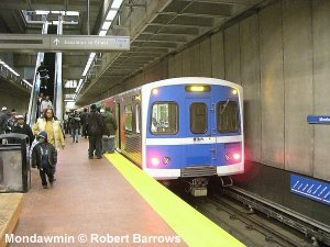
Yep, this is Baltimore's Mondawmin Station! (Photo: Barrows)
The Baltimore Metro rapid rail transit line operates along a 15.5-mile (24.8 km) long route between downtown Baltimore and Owings Mills in the northwest suburbs, with 14 stations serving the communities along the system, and it was built in three sections (opened 8 miles in 1983, 6 miles in 1987 and 1.5 miles in 1995) for a total cost of $1.392 billion. Metro trains are available every eight minutes during morning and afternoon rush hours and every 10-20 minutes other times. Traveling the entire line takes approximately 25 minutes. Free parking is available at all Metro stations between Owings Mill and Mondawmin, inclusive. 
The Baltimore subway is part of President Johnson's Great Society dreams hatched in the 1960s, which gave birth to the aforementioned modern systems which now, 50 years later (Baltimore's system was a long time in the making and is actually only 36 years old, see video) are not so modern any longer. In fact, Baltimore's subway, just as DC's subway, fell almost overnight from being an object of pride to being one of derision thanks to woefully neglected maintenance. In DC it was overcrowding and track fires that brought the system to its knees. In Baltimore the tracks were so worn out, in spite of under-crowding, that the system had to shut down for a while.
62% bus, 9% subway. The opposite from a city with viable transit
Baltimore’s subway was shut down last Friday February 9 after inspectors found 19 curves in the system which should have been removed from service months before, according to an inspection report released by the Maryland Transit Administration.The transit agency closed the Baltimore subway system through March 11 to perform a month of emergency track repairs. The system carries approximately 40,000 trips per day. Grasswire
By now ridership is much lower. The subway manages to attract only about 1/10th of Baltimore's bus ridership which makes up the bulk of Baltimore's transit (62%) while the subway takes only 9% even though one bus can set only some 40 people while a six car subway train consisting of the "Universal Budd Transit Vehicle" also used in Miami can seat more than 10 times that. The busiest subway systems carry some 50,000 - 80,000 riders  per hour  on a single route with trains every 90 seconds (Hongkong). Baltimore's MTA manager Kevin Quinn told Regional Rail Plan Committee members in March that only 28,000 daily riders use his subway, even though the trains run every 8 or 9 minutes during rush hours. Per MTA's new Performance Dashboard monthly ridership data suggest and average of only 18,000 daily riders including weekends. In other words, Baltimore spacious subway carries only half as many people a day as busy systems carry in one hour. This is quite a waste of a significant asset. It led Baltimore based David Dudley, editor of The Atlantic's CityLab to recently pen an article titled: "It’s Time to Celebrate Baltimore’s Much-Maligned Metro."
Once the North Star of the system

There are at least three reasons for the current dismal ridership:
  1. The subway is not part of a system but simply a single line. No riders that would transfer from one train to another. In DC for example, various lines intersect at various places such as MetroCenter with masses of people streaming from one train to another multiplying the possible destinations. In Baltimore, the train only attracts people who want to travel from Owings Mills to Hopkins (or the other way round) or any of the stops in between. Very few people would transfer from the subway to the light rail (which doesn't open up a truly different corridor except for BWI). MARC commuter trains don't connect to Metro at all. 
  2. The subway stations sit in the middle of nowhere except for downtown, Hopkins and now Owings Mills. That means 11 of 14 stations don't have any significant density around them. None where ever developed as density nodes or a transit oriented developments (TOD), a few puny attempts such as Symphony Center or the new Social Security Station at Reisterstown Station notwithstanding. The only real TOD is happening at Owings Mills, and even that features giant garages directly next to the station. 
  3. The system has fallen in disrepair and has become unreliable even though running a single subway line back and forth on time should be about the simplest transit there is. That is, if the track conditions don't force speed reductions, if trains don't break down and if operators show up to work on time. 
The system isn't a great adjunct to Metro, more
its own entity
Obviously, the Red Line would helped to solve problem #1 and the State Center redevelopment would have helped item #2.  Even a fiscal conservative Republican should agree that investing to make best use of assets already on the ground would make sense. But Governor Hogan didn't and nixed the fix for the first two problems what seemed to be more spite than reason.

Still, the first two reasons were already there when the subway had twice the ridership. So the explanation for the drastic drop way beyond the national decline in transit ridership must be the diminishing utility of the service. It is good news, then, that MTA is following through on item  #3 by procuring new subway cars, an initiative that had already been initiated under Governor O'Malley. MTA is also making substantial track repairs. That still leaves crumbling overhead structures, signal systems and other infrastructure needs that can slow service and make  it unreliable.
The Maryland Transit Administration (MTA) has awarded a $400.5 million contract to Hitachi Ansaldo Baltimore Rail Partners LLC to provide 78 new subway cars and a communications-based train control (CBTC) system.
Each bi-directional vehicle has a total seating capacity of 196 passengers. In addition, all interiors, seat layouts, arrangements of accessories, and heating and lighting systems are designed to meet the requirements for access, travel and movement under the Americans with Disabilities Act. (Progressive Railroading)
In a time when even WMATA's Metro loses riders, MTA will not get back to its 50,000 subway rider peak it once claimed to have, no matter how nice the new subway cars may be. Not without significant efforts of linking the subway with high capacity, high frequency bus lines, bringing a lot more development to all the station areas (Park Height's main asset aren't Pimlico's horses but two subway stations!). Ultimately, the line can only survive, if it connects to additional rail transit.  This doesn't even necessarily mean building new lines. A vital connection could be built by a new MARC station at Penn North, provided AMTRAK would move forward with its new tunnel alignment.
MARC continues to be popular

With a speed of up 70mph the Baltimore Metro Link is the only transit connection in our region that can consistently outrun a commuter driving a car from Owings Mills to downtown or Hopkins Hospital. Of course, the Governor is working hard to change that, Robert Moses style. He will feed the (car) addict more opium by reducing beltway congestion on the westside with additional freeway lanes and an all new interchange where I-70 meets the beltway.

The region has an excellent chance to counter this outdated transportation policy with a meaningful regional rail system that seriously seeks to connect Metro, LRT and MARC, a proposition that could effectively serve Baltimore City, Baltimore County and Anne Arundel County. A quite doable proposition requiring only minor tweaks such as a quick shuttle connecting State Center Metro with West Baltimore MARC and a Metro-LRT link at Lexington Station with an express LRT train to BWI and Penn Station. And with the envisoned 2020 Regional Transit Plan, a new rail line may very well reappear as a priority to make our Metro much more meaningful.

Postscript:
Based on online discussion of this article an effective rail or transit connection between the Metro Station at Lexington (or Charles Center) and West Baltimore MARC is high on the list of desired connections. During the Red Line analysis a subway connection to the Lexington subway station was studied. It was expensive and not easy. A Y-shaped rail connection would disrupt the Metro service for an extended period for construction of such a link. A surface rail connection to Charles Center was also studied. Getting the trains from the median of US 40 to an alignment on Saratoga, Fayette or Baltimore Streets requires crossing MLK and several turns. Connections to the existing LRT on Howard Street and the Metro subway would still be not very direct.

Another Metro MARC connection could be created by extending the existing Metro line currently ending at the Hopkins Hospital to where the Amtrak line goes over Broadway and create a MARC Station at that location. Such a solution was included in certain EBDI masterplans. It was not included in the long range MARC plan.

Driverless automated small vehicle shuttles are in service in various places, including operating on public streets (Denver airport, Europe). They could theoretically close the gaps between the rail services through frequent service fully timed with the incoming and connecting rail services. Such vehicles would be much cheaper than the rail solutions discussed above. The public is used to this type service from airports.


Klaus Philipsen, FAIA

Related on this blog:

What exactly was behind the Metro shut-down?


New Metro trains are ordered


Monday, June 10, 2019

A total reset of City Transportation

Now that Mayor Pugh and her handpicked DOT Director Pourciau are both gone, and Baltimore has still no new transit project thanks to the Governor, it is a good time to hit the reset button at Baltimore's Transportation Department for real. Not in the unfortunate way of the last round where demotivated staff left DOT in droves, people that are now missing to work through the significant backlog of things that didn't get done at a department that seemed paralyzed by bad morale.
Traffic signal in Marble Hill: As ancient as a tube radio

Former Director Pourciau's idea to initiate an asset inventory was good. The department has indeed no proper record of signals, sensors, cameras, signs and all the other things that have been stuck into the ground over decades. But doing this inventory cannot come at the cost of everything else. A year into her short tenure, the Director had still been tackling the most basic questions:
  • What infrastructure do we have today?
  • What has been our vision?
  •  What plans have been made for transportation in our city?
  • What are our challenges? –
  • What are the competing physical and financial demands for resources?
These were questions she presented at an interim report of the steps towards a Comprehensive Transportation Plan that Pourciau had given to to the group Transit Choices shortly before she quit.  She reported how goals for transportation policy were derived from analyzing a gazillion plans and their transportation elements in a gigantic effort of bean counting. The problem with this approach is that it was done without ranking those elements for priorities or urgency or without setting them in relation to data, such as crashes, traffic fatalities, speed violations, congestion, slow transit or air pollution, to name just a few metrics that would indicate serious deficiencies and a need for action. By linking those goals culled from dozens and dozens of plans with actually relevant data, a few goals would quickly rise to the top and become a priority. 

Besides, there are surely enough things that need to be turned around because bad performance and poor outcomes are self evident without much study. Poor signal coordination, buses stuck in traffic, lack of directional signs, no guidance to available parking. Anyone walking, biking or driving in Baltimore has their own litany.
Pourciau's Comprehensive Transportation Plan: What will happen?

Some things are systemic. In a city that shrank from a population of 950,000 to about 600,000, there aren't only a lot of vacant houses, there are also a lot surplus traffic signals, signs, islands and traffic lanes. When the JFX, I-95 or MLK were completed, there was never a single lane of traffic or a single signal removed on those routes that had previously taken all the traffic through the center of town.

That there should be surplus capacity may come as a surprise to those who are tuned to the old song about ever growing congestion. Truth is, congestion in high travel growth areas can very well coexist with excess capacity of roadways in other areas of town which have been in decline for decades.  For starters, DOT could probably remove about 1/3 of its traffic signals which would result in immediate savings in energy and upkeep and would reduce red light running and the ill feelings that come from sitting at endless red lights with no traffic anywhere in sight.
Pourciau's Comprehensive Transportation Plan: Fake complexity

Beyond that quantitative change, there is a whole host of qualitative changes in transportation with which DOT needs to catch up, namely the global departure from the tradition of giving at all times the highest priority to the internal combustion engine powered vehicles. This Neanderthal policy of "car first" no matter what, appears to be very hard to shake in Charm City. It still directed DOT when it recently replaced a freshly installed bike lane in favor of a dozen convenient on street parking spots. This happened, even though the City Council made "complete streets" the law, a policy that explicitly prohibits to consider driving by car as the only one mode of transportation that counts. The compendium design guidelines which would outline "complete streets polices" chapter and verse have not been presented to date, and without them, even the brand-new Young administration is continuing the habit of blatantly ignoring the mandates of complete streets.

Pourciau liked to brag that she was the City's largest real estate holder owning about 30% of the City's footprint in the form of public streets and parking lots. She was right about that. With so much land comes a lot of responsibility. Safe, functioning and equitable transportation is the lifeline of any thriving city. So with inventory, a comprehensive plan and complete streets guidelines in the works here a few additional items stuck in the huge planning and construction back-up that DOT has created through inaction, incompetence and, at least in one case, blatant corruption:
Ailing Circulator, poorly enforced bus lanes
  • Achieve a better state of good repair for street pavement, signals and bridges and overpasses
  • Work more seamlessly and effectively with MTA towards making transit faster and more efficient. (Well maintained and enforced transit lanes, signal priority, widened sidewalks at bus stops and safe access to transit stop locations).
  • Set specific air pollution reduction goals for the various transportation modes and effectively implement strategies towards cleaner mobility
  • Eliminate excessively wide one-way streets, eliminate most rush hour parking restrictions and create a program for better pedestrian safety
  • Fix the Circulator and make it a premier form of urban transit which it was for a while. But the system has to operate within its means from dedicated funding sources such as the parking tax surcharge. Simplify routes and cut out any part for which there is no funding. Alternatively get additional funding from developers and institutions which directly benefit from a route.
  • Fix the water taxi. Integrate it with the Circulator, merge tourists and commuter services in terms of fleet and operations and create a dynamic price ticket system that maintains free commuter rides but allows others to pick fare options beyond the $16 day pass. 
  • Get serious about supporting active transportation choices such as walking, scooters, bicycling and whatever other new stuff may come down the pike if it augments how we can get around. Implement the bike masterplan and rename those bike lanes as active transportation lanes.
    Ailing water taxi: Loosing passengers in droves
  • Get serious in prioritizing transit via bus lanes and signal priority.
  • Get in front of rideshare and autonomous vehicles before we hand the city once more to a new technology without first creating a set of policies to manage it. We urgently need the 30% of the city footprint that is public street space and ensure that AVs won't simply extrapolate the undesirable outcomes that ride-share has already wrought on cities. In spite of all the lofty promises to the contrary, ride share brought mostly additional trips and congestion. Self driving cars will enlarge those effects exponentially, unless there will be congestion charges, AV management districts and restrictive parking policies. The AVs could create a transportation nightmare of previously unimaginable dimensions, especially if the technology would proliferate with privately owned cars instead of fleet based, shared vehicles. Without drastic action, the ineffective single-person-occupant vehicle could soon be trumped by the zero-occupant vehicle, indeed the absolute nightmare. Sprawl would get another boost if a one hour commute or more becomes a piece of cake in a car in which one doesn't have to drive but can perform work.
  • Transportation knows no jurisdictional boundaries and must be regionally coordinated. Transit priorities and new operational models such as demand-based micro-transit must be integrated into the earliest version of the new Regional Transit Plan  (RTP) currently underway per state law. Only hand in hand with the surrounding jurisdictions will Baltimore have a chance to manage the centrifugal forces that cars without drivers no doubt represent. 
  • Make equity and sustainability the guiding principles of all matters transportation and in close coordination with other departments such as Housing, Planning, Economic Development (BDC) and Health.
    The AV can save or ransack cities
Without a new director in place, the recently appointed deputy director and man for strategic planning, Theo Ngongang, and the veteran DOT war horse Frank Murphy (the acting director) who knows every traffic signal by first and last name, are an unlikely couple and by their nature no revolutionaries. Still, they have to hit the reset button really hard. Baltimore needs it.

Klaus Philipsen, FAIA


Friday, June 7, 2019

Cab Calloway house - Why fighting its demolition makes sense

In the long brewing debate about how useful the State's project CORE (Creating Opportunities for Renewal and Enterprise) money really is when it is largely used for expediting the demolition of vacant Baltimore rowhouses, jazz legend Cab Calloway got tangled right in the middle.
The 2200 Block of Druid Hill Avenue in winter (Photo: Philipsen)

Young Cab, before he became the well known African American singer, songwriter, and bandleader had lived a while on Druid Hill Avenue in Druid Heights neighborhood, a fact recently brought to light by Marble Hill community gadfly and activist Marti Pitrelli, always looking out for the history of her community and the areas around. Upton, Marble Hill and Druid Heights are all adjacent to Sandtown and a state of disinvestment that makes the history one of the best assets those communities have.  Jazz and African American culture included. So far, preservation hasn't fared well. Of the once famous Royal Theater is only a small token canopy left and the Sphinx Social Club sits stabilized but unfunded for rehabilitation. Pennsylvania Avenue is a sad shadow of its past when segregation made it an African American refuge and cultural hub.
Work on demolition along Baker Street, part of the future park
(Photo: Philipsen)

McCulloh Street and Druid Hill Avenue are the two main streets defining Druid Heights. They are just a couple of blocks away from flourishing Bolton Hill. Lined from Martin Luther King Boulevard to North Avenue with stately three story houses they are testimony of a time when these streets were highly desirable locations. In fact, it was on McCulloh Street where black lawyer McMechen's purchase of a home set off the wave of restrictive covenants that made Baltimore infamous for racial profiling and discrimination in housing.
In response to the attempt by George W. F. McMechen to move into 1834 McCulloh Street in the early summer of 1910, Baltimore moved to establish a formal segregation ordinance which forbid black residents from moving to designated “white blocks” and white residents from moving to designated “colored blocks.” (Baltimore Heritage)
Baltimore's largest Community Development Corporation, DHCDC, is located on McCulloh Street and operates a buzzing community and daycare center there, offering a plethora of services. Its Executive Director, Anthony Pressley, is not happy about Pitrelli's last minute intervention in favor of saving Cab Calloway's home on 2216 Druid Hill Avenue. His community has long begged for the  abandoned houses to be taken down where they form entire blocks. The community has long advocated for a large open space on both sides of Division Street, one block over from Druid Hill Avenue. The idea of that large open space made it into the adopted city Green Network Plan as one of the largest suggested new green spaces created through demolition.
An already cleared part of the future park: Little in terms of focal points
or defined edges (Photo: Philipsen)

So City and DHCDC swapped vacant houses in the 2200 block of Druid Hill Avenue just south of North Avenue until DHCD owned all the ones on the uneven side and the City all the ones on the even side where the park would be. DHCDC received some project CORE money to stabilize their side (money for rehab is still elusive) and the City scraped money together to level their side. The idea was that the one day occupied side would face a beautiful park across the street and help keep it safe.

Then Pitrelli came along and unearthed the Cab Calloway story, hooked up with the musician's grandson, and began to get a lot of traction in the media, all the way to the nightly local TV news.  (Baltimore Sun, Baltimore Brew, Washington Post, Fox News and even in Spanish). Pitrelli is a bit a firebrand and uses terms such as "cultural genocide" to describe the possible demolition of the Calloway house.

What should happen? Could the houses in the entire block be saved? Should the Calloway house be preserved and become some type of museum? Should the block be leveled as planned and the park be named after Calloway with a few marble steps as a memory as the City suggests?
Lafayette Square, West Baltimore (Baltimore Heritage)

My motive and possible qualification to weigh in on this set of questions comes from my work as an architect with the DHCDC which goes back a decade or so and includes the rehabilitation, new construction of rowhouses on McCulloh, Druid Avenue and Baker Street as well as design for a Negro League Baseball Museum on Pennsylvania Avenue for which, so far, only stabilization work was done.

The stately and ornate three story houses on McCulloh and Druid Hill Ave were in just as terrible a shape as the ones in question. But reconstructed and restored with with historic tax credits they became homes for first time home-buyers and helped stabilize the appearnace of the two important streets which have only a few vacant houses left. 17 new constructed homes with front porches were also sold as starter homes on Baker Street and they went like hot-cakes. Another six are currently under construction. The use of historic tax credits requires a thorough investigation of the the history of the area and a demonstration that the preserved homes sit in an intact historic context.
Union Square

Long before the Cab Calloway discovery, I argued for the preservation of the 2200 block of Druid Hill on both sides of the street in the interest of urban design. Preserving both sides of a  tree lined streetscape that continues for many blocks just makes sense, espcially at the beginning, at the portal. Druid Hill Avenue and McCulloh both change direction at North Avenue creating a gateway situation, especially on the south-east bound direction (Druid Hill Avenue). A small pocket park was just recently dedicated there at the corner of Baker Street. Taking down the entire block would open up the view into the future park but also into the haggard fringe around the planned park without any clear focus.

And that is where the whole problem with the parks coming from demolition sets in. Instead of being conceived like the beautiful squares in historic West Baltimore (Lafayette Square, Harlem Park Franklin Square, Union Square and Perkins Square) which are framed by stately buildings and accentuated by churches and anchor buildings, open spaces from demolition are ragged, not framed and not the result of urban design, view corridors or a particular urban layout. Instead, they are spaces derived were it was easy to do because there is no development. The notion that the sheer presence of an open space will lift the values of the surrounding areas to the point that attracts investment is, if not naive, at least unproven.
Calloway house (Photo: Mark Reutter, Baltimore Brew)

Experts of open space design such as Projects for Public Spaces in New York have tons of resources that tell anyone who pays attention that the key of a successful park is active use around the park and a desirable location. A single vacant lot may easily be converted into a community garden, but a site of several acres needs a lot of upkeep and must to be framed by as many active uses as possible to not become an attractive nuisance. There is little chance that the planned Cab Calloway Park can live up to its famous historic brethren, the historic squares. Instead, it is much more likely that such a large open space will become a liability.  The cost for its construction and maintenance can quickly exceed that of fixing up a few vacant houses.

What Druid Heights, a community full of vacant lots and green spaces, needs more than anything is people who can live under decent conditions in the community and who bring more eyes to the street and replenish a community which has been bleeding for decades.  Project CORE funds should emphasize decent housing, additional residents, healthy housing. It should also cherish and leverage history. This can't be done through more demolition.

Klaus Philipsen, FAIA

Related on Community Architect: What it Takes to Rebuild a Neighborhood: Example Druid Heights

Thursday, June 6, 2019

Why Tearing Down HarborPlace Is a Good Idea

The Inner Harbor famously put Baltimore on the map back in the 1980s and was the poster child of what was then called the "Baltimore Renaissance". HarborPlace was envisioned as Baltimore's "living room", not as a tourist attraction. The two "Festival Marketplace" pavilions were the brainchild of the Rouse company and the entire conversion of a smelly, derelict and forgotten once working waterfront into an area to celebrate water was imitated the world over, from Sidney to Norfolk.
An aerial picture after urban renewal and before the re-build. 

Now, 40 years later, the Festival Marketplace, once a symbol of urban renewal in more than 40 cities in America is dead. Many of those later venues have already been torn down (South Street Seaport, New York) or reinvented (downtown Lexington, KY). Baltimore's two pavilions stand seemingly unchanged. But they have been ailing for years and the latest owner, Ashkanazy was as unable to turn the decline around as general Growth before, in spite of a large remodeling concept announced in 2015 and only partly completed in 2019. Now the owner defaulted on its loans and lost the property in a complicated process of receivership which nobody seems to fully understand. Baltimore's new Mayor, Jack Young boldly stated that he would like to see the aging Harborplace pavilions "torn down and redone."

Young's idea of tearing down those pavilions is a good one; the idea of rebuilding the area to resemble "National Harbor" not so much. Let's explain why.
The Festival Market Place, still attractive from the outside, empty
on the inside

Back when Baltimore's Inner Harbor was re-invented for enjoyment, the shoreline was pretty much a blank slate, in part, because urban renewal was quite demolition happy. The pavilions created a sense of place in the flatlands that were all around along Pratt and Light Street. But Baltimoreans had begun to like their largely wide open event space and almost defeated the idea of HarborPlac in a referendum.

Today, Wallace Robert Todd's Inner Harbor 1964 masterplan which guided much of the Inner Harbor development (except for the freeway bridges) is mostly realized. With the 404 Light Street tower the outer "frame" around the water is almost complete (except for the surface lot on Pratt, once was the News American building, it is still a parking lot). Pratt Street is well underway towards becoming the envisioned urban boulevard, even though it is choking on traffic on too many lanes. The role of the pavilions changed dramatically, not only from a retail persepctive but also in terms of urban design and place-making.

The two pavilions always blocked the the view of the water and presented their backs to two major streets, but today this unfriendly "attitude" towards the street and downtown is seen much more critical.  Ashanazi's plans tried to make this visual blockage and "back of house side" more attractive. But any such attempt runs into systemic problems: Access, service, trash and all the unattractive stuff has to be somewhere. (Unless you put it underground as on the World Trade center, where it famously drowned when the water rose as it tends to do more often now). From a retail perspective, the pavilions suffer from having morphed from "markets" (with an actual fish-monger and a showy ice cream and fudge maker) to inward looking little malls the ubiquitous national chain stores, not good in a time when malls die at a record pace.
ASG rendering of a connected McKeldin Plaza: The pavilions stayed in this
vision. (Ayers Saint Gross)

So tearing down at least one of the two pavilions is a great idea. It would solve the issue of an unattractive backside and would open up the view to the water and Baltimore's flagship, the Constellation. Ideally both pavilions would disappear, but then one has to consider that people still want to have shelter, shade, protected outdoor seating areas, want to eat, use the bathroom and buy tickets for the attractions. All that could be consolidated in the Pratt Street pavilion. Reduced to its bones and much more open it would reamain recognizable but serve a new function. This one pavilion would accommodate all that junk that sits around in little and not so little booths (think: the ugly Constellation building). As a result the Inner Harbor would gain breathing space, feel much more airy and create extend to the tall buildings across Pratt and Light Streets which form "the frame", connect to downtown and have plenty of space for whatever retail would still work down there.

Of course, while Mayor Young is thinking big, he should also close the traffic dogleg that separates the McKeldin Plaza from Harborplace and replace the demolished former McKeldin Fountain with something attractive. Maybe a memorable sculpture like at National Harbor? (Otherwise, National Harbor with all its predictable chains is a pale imitation of the Inner Harbor, copying it back here would be the peak of irony.
The Inner Harbor as playground for the neighborhoods today

The point of the exercise would be to return HarborPlace to something that Jim Rouse had envisioned all along: A commons for Baltimore, a place where residents feel like they own it. Once that is true, visitors will like it too. (Just like the Boston Commons). It was a mistake to privatize the Inner Harbor and leave it to tourists with Bubba Gump, Ripley's and a bunch of cheesy chain stores that anyone can see everywhere.

Instead, here is an opportunity to recapture the Harbor for the people of Baltimore and make it truly authentic with a true focus on the water as a theme (bring back fisher boats and fish-markets). Every city needs a commons, just as every home has a living room or kitchen which serves as the place where the family gathers, no matter how nice the bedrooms. The often used pseudo dichotomy between downtown and the neighborhoods is a false choice. All neighborhoods need a space to share and that has always been downtown. No reason to change that only because people now live downtown as well. (A good thing!).
The space itself was the attraction: Inner Harbor 1973

If the Inner Harbor would work as the playground and living room for all, there would also be much less of a desire for youth to go there to chase tourists. So yes, Mayor Young, remain bold and go for demolition. Take the land back as a public domain and end the reign of private developers controlling the city's commons.

Klaus Philipsen, FAIA

related articles on Community Architect:
The failed concept of Harborplace (April 2018)

Ashkanazi "removes the identity of these sheds" (Nov 2015)

Monday, June 3, 2019

Big names and ideas for Baltimore's "second waterfront"

30 years of planning

The year was 1990 and Baltimore's young architects organized in the Urban Design Committee published a little booklet with ideas what to do with the Middle Branch. The context then was the football stadium to be constructed south of Camden Yards and the notion that such a stadium should spawn a larger masterplan which would address "Baltimore second waterfront". The architects envisioned a softer, greener and more natural waterfront, contrasting from the first waterfront, the Inner Harbor. Alas, the Ravens' nest was built without a masterplan and the Middle Branch languished.

However, in 2005 the Planning Department had taken on the notion of masterplanning and communicated with the architects again about ideas for the Middle Branch. The AIA provided a set of recommendations, including this one:
Baltimore's second waterfront (Middle Branch
Masterplan)
The area around the Middle Branch “basin” might be considered as a series “communities” within with the Middle Branch as the common element.  The Westport shoreline is an opportunity to create a mixed-use “Village” along the water.  The parkland is more of a green zone, while the opposite shore can be defined as a low-lying institutional/business/etc. area with increasing mass and height towards the peripheral roadways. (from 2005 AIA-UDC letter to Planning)
In 2007 the Middle Branch Masterplan was finally adopted. Meanwhile Pat Turner claimed, planned, and lost Westport. One of his consultants was the the landscape firm Field Operations.

In 2016 Under Armor claimed Port Covington and obtained Westport in foreclosure.  Their landscape consultant in the masterplanning stage was Landworks Studio in Boston.  In 2018 Weller Development issued a request for proposals for landscape architecture.  The Port Covington team is still set on the development of the full 235-acre, multi-decade, $5.5-billion project of Port Covington, and the Tax Increment Financing (TIF) bond funds which include also the reconstruction of the Spring Gardens Swing Bridge into a pedestrian bridge that would connect Westport to Port Covington near Swann Park.

Competition with world stars in green design

Finally, now in 2019 the Parks and People Foundation announced three finalists for their landscape design idea competition funded from Casino impact funds. From an initial pool of 50 "world class landscape architecture teams", three teams emerged as finalists: Hargreaves Associates, James Corner Field Operations, and West8. The idea concepts deal with 11 miles of waterfront and can be viewed here.
Sagamore maserplan renderings of Middle Branch waterfront park
“Our vision for the Middle Branch Waterfront is that it will be the newest crown jewel in Baltimore’s inventory of great public parks: one of the country’s next great urban waterfronts,” Lisa Schroeder, CEO of the Parks and People Foundation
“Every once in a while, there comes an idea that’s bigger than all of us put together, and the Middle Branch is one of them,” Chris Ryer, director of the Department of Planning.
The shortlisted firms are big names anywhere in the world and it is an achievement to have been able to attract them to produce ideas for Baltimore's "second waterfront" in spite of uncertain funding and Baltimore's long history of wavering when it comes to follow through.
Middle Branch aerial photo with cleared Westport side on the left

The unkind treatment of the Middle Branch.

Even after the Inner Harbor had been discovered as an attraction, the Middle Branch only got the boot. On its shores were installed: a tank farm, an Interstate exchange, an animal shelter, a waste incinerator, a hospital, a Greyhound Station and a Sams Club (now Under Armour's HR department). Even after the architect's initial foray in favor of better treatment and after the adoption of the masterplan in 2007, the Middle Branch did not fair much better than before.

  • The Baltimore Development Corporation changed the area east of Russell Street form being part of the Carroll Camden industrial park to a sports entertainment area with a sports center that emerged as the winning contender only to be squashed by Baltimore's eagerness to land a casino. As a result a good piece of Middle Branch located along Warner Street was ruined by the gigantic Horseshoe Casino garage and cut off from access and view.


  • Field Operation's green dreams for the New Westport fell by the wayside when Turner Development had to give up the 43 acre site which sits fallow ever since the BGE facility and the Carr Lowry Glass Company had been leveled.


  • A 2015 Gateway Masterplan conceived to guide the use of Casino funds was full of generalities and lofty goals and very short of actual guidance.

!990 AIA Urban Design Committee Report

  • A West Covington Park designed for bird-watching was constructed as part of an agreement with the Aquarium to build a facility on the site of a former municipal bus garage at the foot of the Hanover Street Bridge. The many trees had barely taken root and grown a bit when the park changed hands and Weller Development re-imagined the park as an active place with a sports bar, a ball field and sand lots for volley ball. Hundreds of trees were removed requiring off site mitigation somewhere. (The short life of West Covington Park)


The bright spots of an emerging Middle Branch green system

But good things also happened. How a green oasis can look becomes clear when one looks at the Masonville Cove.
In 2003, the Baltimore Harbor team proposed a study of the Masonville site for dredged materials. In 2004, there came an opportunity for environmental revitalization when the Army Corp of Engineers and the Maryland Port Administration offered to restore and preserve the natural beauty of Masonville Cove and construct an environmental education center as part of a harbor dredging project.
Since 2007, restoration of Masonville Cove has been underway, including removing derelict vessels from the water and removing over 14,000 tons of wood and assorted debris. The wood was used as fuel for electricity generation in
Gwynns Falls Trail at Middle Branch Park
Pennsylvania and recovered metal debris was recycled. The concrete debris was stockpiled to build artificial reefs to provide a home and shelter for fish, crabs and oyster beds. (Website) 
The Gwynns Falls Trail system was fleshed out with a waterfront trail spur which ends at the Harbor Hospital, allowing a flavor of the potential of the Middle Branch as a waterfront park system including the fantastic views of downtown. The existing Middle Branch Park on the south-shore, where Baltimore's Rowing Club has its home has received $150,000 Casino money through the South Baltimore Gateway Partnership for landscape upgrading. Port Covington started out with the Distillery and the conversion of the Sam Club, both with well designed waterfront parks.


The current competition ideas:

The descriptions of the shortlisted landscape architecture firms come from their websites. Below they are followed by a summary of what the concepts propose. ((The online Parks & People website has combined all boards into slide show-videos, making a direct comparison extremely cumbersome).

All participants were invited to suggest a phasing plan based on the fact that whatever funding for implementation would only realize over a 10 year period.
Hargreaves Jones is a landscape architecture and planning firm in New York City that practices around the globe on a wide range of urban design, waterfront, public park, academic, corporate, institutional, and residential projects with a focus on the creation of memorable landscapes. These projects range in scale from miles of riverfront or 1000’s of acres of parkland to urban parks, gardens and plazas. (Video)
Hargraves Jones rendering
The firm may be best known through their Olympic Fields in London. Their idea boards show a trail system throughout the area with new pedestrian bridges including a connection via the old railroad turn bridge as previously assumed in the Sagamore masterplanThey dubbed their concept "Patapsco Strand". There are new wetlands in "Ridgely's Cove", a new Westport promenade, and a floating swimming pool. The Middle Branch and Park Smith Cove sport a real beach, there are also an event lawn, a performance pavilion, a market plaza and a shade pavilion as well as wetlands and boardwalks, in short an assortment of what one would expect along a recreational waterfront that one day may be clean enough for direct water contact. The team is augmented by the local members Living Design Lab, and the Neighborhood Design Center.
Hargraves Jones Middle Branch Park
James Corner Field Operations is a leading-edge landscape architecture and urban design practice with offices in New York, San Francisco and Philadelphia. The practice is renowned for bold, transformative design in complex urban environments, inspired by place and culture, and informed by an inclusive and engaging process. In all of the work, there is a deep commitment to reconnecting people to nature in the City through the design of a vibrant and dynamic public realm that integrates ecology, program and people. (Video)
James Corner of Field Operations is best known through the New York High Line project. As noted, the team is already familiar with the area from the work on the Westport concepts. Not satisfied with the proposed widened sidewalks and bike-lanes on the Hanover Bridge reconstruction (not fully funded yet) the team has added a separate new pedestrian bridge adjacent to the historic bridge just for peds and bikes. The new bridge would be part of a trail system around the waterfront that includes promenades and bridges in Ridgely’s Cove that hang from the overhead Interstate bridges. The old railroad turn bridge is converted to a pier coming off a pedestrian bridge. Water overlook terraces and a beach are added to West Covington Park which Sagamore now calls South Point.The concept dubbed "Shorelines" plans "social porches" in the form of beaches, a kayak and canoe launch, fishing piers, and a picnic place along the Middle Branch Park and Smith Cove,  and a swimming pier adjacent to Sagamore Spirit Distillery. The firm is locally supported by Biohabitat Baltimore and Moffatt Nichol, a civil engineer that also works with Sagamore.
Field Operations: Suspended trails
West 8 is an award-winning international office for urban design and landscape architecture founded in 1987. Over the last 32 years, West 8 has established itself as a leading practice with an international team of 70 landscape architects, urban designers, architects and industrial engineers. West 8 has offices in Rotterdam, Belgium and in New York City. With a multi-disciplinary approach to complex design issues, West 8 has extensive experience in large-scale urban master planning and design, landscape interventions, waterfront projects, parks, squares and gardens. (Video)
Field Operations Overview Plan
West8's maybe most prominent project is the landscape design of Governor's Island in New York. For the Middle Branch the team came up with the boldest and most expensive idea: The team suggests converting the Hanover Bridge into a linear park and constructing a new vehicular bridge from the center of Port Covington next to Under Armour’s planned future headquarters, into Brooklyn. The long new bridge would be broken up by a new island. This reconfiguration of the transportation network has many implications on both ends which will, no doubt, trigger a lot of discussion during the public comment period underway until June 8.

West8 also added a trail system looping around the Middle Branch and into Ridgely’s Cove with new pedestrian bridges and new marshlands adjacent to each shoreline. The plan also converts the Spring Gardens Swing Bridge into a pedestrian bridge. Other accessories include a band shell and amphitheater at the Middle Branch Park and additional water taxi stops. West8 has local support from Mahan Rykiel Associates and Moffatt Nickel. 
West8 overview plan with new road bridge

After being shortlisted all three firms will engage with the community through online comments and meetings. A "winner" will be selected by a yet to be named jury after the comment period ends on June 12. According to the Parks and People website, the process "is overseen by the Parks & People Foundation  under a contract with the City of Baltimore and the South Baltimore Gateway Partnership with the goal to recruit highly qualified experts to assist in finding the best team to work with Baltimore on this exciting initiative." The project is supported by a working group, advisory committees and a variety of active stakeholders, including a steering committee, comprised of property owners, community representatives, government leaders, elected officials and technical experts.

The three designs concepts were revealed on May 30 at an event where Mayor Bernard C. “Jack” Young, Frank Lance, President & CEO, Parks & People, Michael Middleton, Chairman, SB7 Coalition, Inc., Senator Bill Ferguson and Delegate Brooke Lierman as well as Dr. Benjamin Wu, from the Maryland Department of Commerce, Deputy Secretary, Reginald Moore, Director, Baltimore City Department of Recreation and Parks, Chris Ryer, Director of Planning; Brad Rogers, Executive Director, South Baltimore Gateway Partnership, and Baltimore City Councilman Eric Costello of the 11th District expressed their excitement about the ideas.


What's next?

West8 detail for Ridgely's Cove
The public feedback will be shared with a jury of community representatives and technical experts who will assess the entries, take the comments into consideration, interview the firms, and then recommend a firm to Mayor Bernard C. “Jack” Young.

The process doesn't follow typical design competitions which let a professional jury select a concept based on design but is mostly based on the firm's reputation and allows public input which should mean that the presented concepts could change significantly.

In-person exhibits and online comments will run Thursday, May 30 through Wednesday, June 12 at the Enoch Pratt Free Library Cherry Hill Branch and at City Garage.

How many of the will ideas will eventually be implemented will largely depend on how casino revenues develop (they are on a downward trajectory) and how Sagamore's Port Covington progresses. ("Chapter One is about to begin construction).  Much more than the Inner Harbor, the Middle Branch could really become a waterfront of and for the neighborhoods. 

Klaus Philipsen, FAIA