Wednesday, July 26, 2017

The Baltimore Demolition Protocol

Regardless of the difference in opinion about how smart mass demolition is in a City that plans its comeback through population growth, demolition is in itself a risky activity with a good number of inherent risks including contamination of air and neighboring sites. It is good then to know that Baltimore led the nation with what is known as the Baltimore Demolition Protocol. Or maybe not.
Lead poisoning leads to crippling mental and physical health effects.  Lead-based paint in older homes becomes a toxic dust storm when whole neighborhoods are demolished for new growth. Yet, nowhere in the United States were there any construction protocols minimizing health risks during building demolition. That is, until 2004 when the Annie E. Casey Foundation and Johns Hopkins University took East Baltimore, Maryland, resident concerns to heart and created a whole new rulebook. (Anne E. Casey website)
Rowhouse demo on Fort Ave at the moment when things went wrong
The matter came to a head when EBDI had begun mass demolition around Washington Street in what would later be known the phase 1 area of redevelopment, essentially the area just north of the Hopkins campus and Ashland Street. When the dust rose from the collapsing rowhouses of what was once the Middle East neighborhood the Save Middle East Action Coalition (SMEAC), already incensed by EBDI's elephant in the china store approach in the community and the ensuing displacement, jumped into action. Their complaints were numerous: There was only scant water spraying, neighbors kept their windows open during demolition work and kids were found wandering through the unprotected contaminated rubble. SMEAC forced a much more careful method of demolition that was the result of months of community meetings and collaboration between EBDI, Casey, Hopkins and SMEAC.

A Casey funded report in 2011 gained national attention by establishing the Baltimore Protocol. The protocol includes
  • fencing, 
  • community notification through documented signs, 
  • training of demolition supervisors, 
  • deconstruction of specific high lead items such as windows, doors, and stair railings prior to demolition, 
  • ample spraying during demolition and debris removal, 
  • careful street and sidewalk cleaning to remove residual dust, topsoil removal 
  • replacement of the yards of demolition lots, 
  • providing neighbors with HEPA vacuums and independent testing of the area after the demolition and cleaning is done. 
The city of Baltimore introduced a plan to revitalize East Baltimore and spurred new safety standards that may change the future of demolitions across the country. Before East Baltimore’s redevelopment, little research existed on the effect demolitions had on a neighborhood’s ambient air quality. A 2003 study analyzed lead dust and accumulation from sites near EBRI’s redevelopment site. Results showed that, following demolition, lead dust levels in the environment increased by as much as 40 times, and there was a 6-fold increase during debris removal. 
The EBDI demolition protocol proved to be so effective and associated costs so minimal that in 2007 the city of Baltimore revised its building code so that safety measures from the EBDI protocol are now a citywide standard. The state of Maryland is also considering adopting new legislative standards that would require similar safety measures be used throughout the state. (HUD user online)
Tests using the protocol showed that lead contamination was much lower ( a 33% increase over the baseline levels) than in cases where the protocol was not used (150 -400% increase over the baseline). At the time the City, Maryland Assembly and even HUD had indicated a desire to adopt these standards and making them mandatory.
Demolition of entire blocks, a trademark of project CORE

It is fairly astounding, then, to hear the HCD Commissioner in July 2017 at a CORE progress event respond to a question about the safety of the City demolition program. Michael Braverman stated that the City is "currently studying" the demolition protocol of the Maryland Stadium Authority (MSA) and intends to implement it "when the review is done".

Why weren't the Baltimore Standards of 2011 used in those past six years if they were supposedly part of the code as HUD reported? Why is MSA studying the matter anew? Why did an emergency demolition earlier this year still create not only a large plume of dust wafting over Fort Street in South Baltimore but was also done so incompetently that it destroyed a second building that had been slated to be be rehabilitated? Sometimes Baltimore is ahead and then slips back again.

Klaus Philipsen, FAIA

An effort of getting a comment from Baltimore Housing was unsuccessful to date.

Tuesday, July 25, 2017

See the designs coming to Leakin Park!

Winans Meadow NatureCenter rendering (GWWO Architects)
The Baltimore City Department of Recreation and Parks plans to spend over $25 million for new facilities in Leakin Park.

The improvements include the new construction of the 1972 Cahill Recreation Center on Clifton Avenue (nope, this isn't at Clifton Park!) a new youth group campground off of Gwynns Falls Parkway, improvements at the entry to Leakin Park at Sloman Drive and a new nature center at Winans Meadow. $750,000 dollars
The site overview plan for facilities in the Winans Meadow area (BCRP)
will come from the federal government's Department of the Interior and are dedicated to the camp.

The debates about Baltimore spending priorities are epic, including the fact that police and "security" eat up a much larger portion of the Baltimore budget than education and recreation. The modernization of the Cahill Rec center and the camp are, therefore, particularly welcome steps in re-calibrating priorities. A comprehensive evaluation of recreation centers and aquatic facilities was performed in 2015 under then Mayor Rawlings Blake and the relevant budget items are included
Winans Meadow Nature Center (GWWO)

Leakin Park, overview plan of capital improvements (BCRP)
in Baltimore's six year capital budget.

The proposed designs for the Winans Meadow visitor center and Camp sites are initial proposals and subject to review by the communities and stakeholders according to Kate Brower, an urban planner in the capital division of Baltimore City Recreation and Parks.

The architects for the projects are GWWO Architects of Baltimore with project management by Baltimore Architect Lance Decker.


Klaus Philipsen, FAIA

updated: 8/31/17 per corrections provided by BCDRP regarding the total investment value, the community participation and the Cahill site plan.

In the next weeks articles on this site will appear less regularly due to travel

Baltimore Fishbowl article about Leakin Park
SUN story about Cahill Recreation Center


Cahill recreation center (GWWO Architects)

Cahill Recreation Center after enlargement (GWWO Architects)

Site overview of proposed Outward Bound Camp (BCRP)

Update Cahill site plan

Proposed floor plan Visitor Center (GWWO)


Monday, July 24, 2017

Leakin Park- back from the dead

To some Leakin Park is the place where I-70 went to die after it traversed the country over a total length of 2,151 miles in defeat of Robert Moses (yes, he also advised Baltimore!) and as a victory in Baltimore's highway wars. To others it is the place where dead bodies are disposed, a narrative that has its own blog and was further advanced by Sarah Koenig's Serial podcast and by David Simon's Wire. Geographers know that the Park is located in Dead Run valley. Death seems indelibly inscribed on this Baltimore Park, but the truth is much more glorious, not only in its past but also its presence and future.
Leakin Park historic mansion wagon road

Few know that Frederick Law Olmsted and his sons left a lasting legacy not only in New York's Central Park but also in many places in Baltimore including Leakin Park. (The Junior wrote a 1904 report titled Report upon the Development of Public Grounds for Baltimore). Even fewer people are aware that Leakin Park is the nation's second largest urban wilderness park or that it contains a few of Maryland's old forest specimen trees, that lawyer and philanthropist Wilson Leakin was originally behind the idea of such a park by bequeathing downtown buildings to the City in 1922 so Baltimore would have the funds to buy parkland. Few know that Frederick Law Olmsted Jr. helped to get the City to finally follow through with buying the 243 acre Crimea Estate which was part of the land holdings of railroad baron Thomas Winans who had made especially much money in Russia.
This valley [Dead Run], of all those discussed, has been freer from defacement by man’s activities. It is considered by all who view it as one of the very best bits of scenery near Baltimore. --Olmsted Brothers, Report and Recommendations on Park Extension for Baltimore, 1926 
Mill wheel in Leakin Park

In 1939 the City was still bickering and waffling about the right way to invest the proceeds from Leakin's will and Olmsted once again reminded the city fathers that the park should be located in a
neighborhood where recreational space was lacking and also that the new park should provide diverse activities for people of different age groups and social classes, a view still apropos today. Finally, in 1941 the City finally followed through and purchased the land from Winans for $109,486.

Today's park totals 1,216 acres which makes it bigger than Central Park. People with a dim view of the condition of Baltimore's parks should take a fresh look. Leaking Park like most other Baltimore Parks present themselves in a well groomed and clean shaven manner with cut lawns, working park lights, benches and freshly painted gazebos.

According to the website of the City's Parks Department the upland Crimea section of Leakin Park became home to a number of ongoing programs during the early 1980s including the Carrie Murray Nature Center, named for the mother of Baltimore Orioles great, Eddie Murray, which provides nature programs and activities. The Baltimore Chesapeake Bay Outward Bound Center offers outdoor adventure programs for youths and adults.

Winands Meadow and shelter: Always kept in good repair
Other park traditions from the same period include the annual Baltimore Herb Festival, held each spring, and the miniature trains operated by the Chesapeake and Allegheny Steam Preservation Society offering free rides on the second Sundays of the month from April through November. The uplands section of the park off of Windsor Mill Road also features historic structures that date from the original Winans era, including the Orianda mansion, a wooden Gothic chapel, and several stone buildings. It is hard to see how, but a department that has been subjected to budget cuts time and again is keeping its assets in good shape, frequently in close collaboration with non-profits such as the Friends of Leakin Park. (See My Park, My Story with founding member Heide Grundmann here. She assisted in defeating the freeway plans and still programs events at the Park).

In recent years the park has seen a series of investments for the accessible 15 mile Gwynns Falls bike and hike trail from Franklintown to Carrol Park, a new event and band shelter on Winands meadow, a bathroom facility there and improved ball fields in the park area near Rosemont.

Current capital improvement plans include revamping a 1930s scout camp in the Cahill area and a new visitor's center that may replace the bathroom structure at Winands Meadow depending on still to be held community participation meetings according to Kate Brower at the Department of Recreation and Parks.  Community Architect Daily will report about the planned improvements in a separate story.

Today Leakin Park's beauty and offerings far outshine the shadow its dead bodies have cast over it in the past. Just as Olmsted had envisioned it, the park offers a quiet respite to those who seek it out as a counterpoint to the urban bustle.
Biking the Gwynns Falls trail
Two miles from the skyscrapers of Pratt Street, we felt as if we had entered the Shenandoah Valley. Amber and crimson leaves fell slowly in the breeze as we gazed across the Gywnns Falls valley. The falls rushed over giant boulders as we rode on the secluded paths, past old stone ruins and enormous trees, the city at once all around us and seemingly worlds away. For two hours, it was just the three of us, up and down the switchbacks, until the trail ended at the I-70 park and ride. (Rona Cobell, Slate, Nov. 2014)

Klaus Philipsen, FAIA

Recreation and Parks Info
Bay Journal

Friday, July 21, 2017

Hyperloop, Maglev or NEC?

The $2.9 million Red Line started in a regional long range transportation plan and died 10 years later in conventional press conference.
The unspecified cost Hyperloop train between Washington and New York has no costs, no plans and no budget and started with a Tweet.
Hyperloop in Nevada: Mirage in the desert?

People frustrated will the slow progress of government regulated projects and love the tech hyperbole tend to prefer the Tweet approach. Except, there is no proof that high-flyers like Mr. Musk can do a public project any faster, no matter how fast he has catapulted his Tesla car company (sales: 26,000 cars in 2016) from zero to being higher valued than General Motors (sales: 10 million cars in 2016) in large part by bringing innovative models faster to market than anybody else.

Proof that private money and engineering ingenuity alone don't guarantee speed, no matter how fast the proposed technology is MagLev, another futuristic train proposed by a private consortium between Washington and New York. Even the first tiny leg that is supposed to serve as proof of concept is currently no further than the conventional rail improvement project NEC proposed by Amtrak: Environmental review under NEPA laws. It is also useful to remember that Maglev has seen no less than five previous studies going as far back as 1994 and none went any further tahn the completion of an Environmental Impact Study between 2003-07).
Tech wunderkind Elon Musk: Not yet deflated

Tweeting Elon Musk and his millions of Twitter followers will have to go through the same slug of a process as well, no matter that he sat at the President's economic advisory council  (he presumably left the table after Trump announced leaving the Paris Climate Accord) and apparently had "positive conversation" at the White House about his project or has influential local admirers (Plank's Damian Costa tweeted Thursday: "If you want this to happen fast, please let your local and federal elected officials know. Makes a big difference if they hear from you").

So what is it exactly what makes the tech world and everybody else hyper-ventilate so much that the official statement by Mayor Pugh seems moderate by comparison?
“I am excited to hear about Elon Musk’s underground Hyperloop connecting New York to Washington, DC through Baltimore. If his plan becomes a reality it has tremendous potential to create new opportunities for Baltimore and transform the way we link to neighboring cities.” Mayor Catherine E. Pugh, City of Baltimore
 The now famous tweet stated Musk had been given “verbal” government “approval” for his vision, in which his Boring Company would build an underground transportation Hyperloop system connecting New York City to Philadelphia to Baltimore and DC for a total trip time of 29 minutes. (Note, he didn't even say 30 minutes!). Leaving alone the pesky political question who provided such approval which would usually take years to get, how would Hyperloop work?

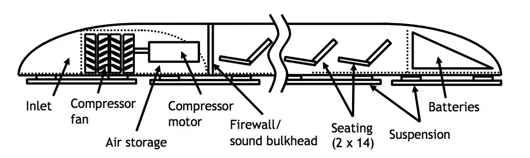
Of course, there is no Hyperloop operating anywhere nor has even a test track been built. The only photos of an actual experiment exist from a Nevada surface test sled. The idea is to put tracks and electromagnets inside an underground tube and vacuum the air out. Ultimately, capsules (Musk's Hyperloop company talks about 8.5 meters in length, shorter than a historic streetcar) will scream through the center of such a tube at just under sonic 700 miles per hour on a cushion of remaining air propelled by intermittent electromagnets in the tube walls every 40-50 miles plus a fan on the pod for continuous propulsion, all together faster than any currently available planes or trains.
Hyperloop rendering
“The thing about Hyperloop is that it does not exist until it actually exists, [...]“We build fast, adapt fast, and get a lot more data rather than wait and wait until one final build, which may or may not work,”” Josh Giegel, vice president of design and analysis at Hyperloop Tech to the MIT Technology Review in May 2016)
Musk's Space X company proved that he could fly a craft into space only five years after incorporating, just like the Tesla car this was a technology around for decades (there were electric cars in the 1920s and spacecraft since the 1960s). In fact, the first vacuum tube train was actually built even before that, in 1845 between London and Croyden, still an active 7.5 mile rail corridor south of central London. The train reached 70 mph, faster than anything else at the time. But it was beaten after only two years by its incompatibility with traditional rail with steam engines that had quickly expanded to the worldwide conventional rail network which is still the norm today.
Concept section of a pod (Space X)

"Politicians won’t believe in it until it exists" says Rob Lloyd, Hyperloop's Tech CEO who tried US states to provide some money for his start-up. Well, they believe in Musk's Tweet, but when it comes to money, they haven't opened tax payer coffers (yet) except for Nevada, the only state where prostitution is also legal. It somehow aided with the test area.

Investor Shervin Pishevar says “Transportation is the new broadband” envisioning a hyperloop network between cities that would also transport freight, but a big flow of capital towards the hyperloop technology isn't visible yet even though Musk wrote in 2013 a nice white paper explaining the general physics of the hyperloop concept including how he would overcome the Kantrowitz limit of air resistance in a tube and deal with earthquakes and farmers.
The approach that I believe would overcome the Kantrowitz limit is to mount
an electric compressor fan on the nose of the pod that actively transfers high
pressure air from the front to the rear of the vessel. This is like having a pump
in the head of the syringe actively relieving pressure.
It would also simultaneously solve another problem, which is how to create a
low friction suspension system when traveling at over 700 mph. Wheels don’t
work very well at that sort of speed, but a cushion of air does. (Elon Musk white paper)
Technology may not be the biggest hurdle for the Hyperloop, even though there are a gazillion issues when actual human passengers are involved who actually want to get on and off at stations and disrupt the nice magnetic vacuum dreams with their usual frailty, fear, cost aversion and slowness, all human properties which have stopped big dreams before, such as the hypersonic air travel such as the beautiful French Concorde which was mothballed a few years back.
Vacuums have a nasty habit of killing living organisms really fast (unless you are a tardigrade, in which case you're fine). So, in the event of an emergency, passengers cannot leave the pod until the tube itself is re-pressurized. [...] the air will not move slowly into the system but instead create a powerful air front [....] close to the speed of sound. Such a front could devastate any pods in the entire length of tube  Robin Mitchel in All About Circuits)
NEPA timeline for MagLev: Years of studies
The real obstacle is going to be two global forces which will slow the project from two sides, capitalism and government. Capitalism because it puts money only where there is a return and government because it has a terrible time regulating something that didn't exist before.

Putting a 200 mile tunnel project with various stations through an established funding and review process will take its merry time if it ever happens. Maglev's " approach to built a much shorter track just between Washington and Baltimore as a "proof of concept"  will make even less sense with a system that dreams about reaching twice the speed.  (Both systems really make only sense over large distances)
TGV: Record steel rail speed at 357 mph


One day steel-wheel on steel-rail technology will have to come to an end, but for this to be soon cutting edge conventional trains run just too well. 350mph reached by the TGV would probably just do fine, even between New York and DC, let alone that such a train could actually continue to Miami, even if those tracks would still allow only 70mph.

Klaus Philipsen, FAIA

The Hyperloop: Ambitious Goals and Engineering Challenges 
Musk Hyperloop Alpha White Paper

Thursday, July 20, 2017

Still no steam in the pipe

Maybe it is comforting to know that the multinational infrastructure giant Veolia cannot repair its blown up steam pipe much faster than the department of Public Works of Baltimore its sewer main collapses. But the result for the rest of us is the same: Closed off streets, dirt noise and disruption.
Eutaw Street remains closed at Lombard Street: Complete by mid-August?
(Photo: Philipsen)

Probably it doesn't make much difference who owns the pipe anyway, in either case on-call infrastructure contractors do the fix and either case they have to deal with old pipes and a bunch of interfering other lines, cables and pipes that are in the way of the repair.

The steam pipe blow-up happened on game night on June 19 and injured five people, lifted an at least  10" slab of concrete out of the street and ejected asbestos laden mud like a volcano and damaged 33 parked vehicles.

On July 19 it was game night again and the section of Eutaw Street between Lombard and Pratt remained hermetically sealed of with 8" chainlink fences with screens as if the secret tests would be performed behind the curtain. Initially Veolia had spoken from a few days needed for the repair, then a few weeks. Now it is a month.

The Veolia job site supervisor being asked about the status initially allowed only that "it is hot". Upon further questions he explained that the pipes in the section were from the 1940s but that repairs had taken place in parts before so that only short segments had still asbestos insulation at the time of the explosion. He noted that the entire old pipe was ductile iron and was being now replaced with a new insulated cast iron pipe. Ductile iron isn't as heat resistant as grey cast iron, but without more information its hard to know whether the old ductile iron pipe in itself caused the failure.
Asked why the 300' trench is being covered with steel plates every night, even though the fence secures the site the supervisor said: "Because the indigenous people get in anyway". Finally upon being pressed for some estimated completion day, he stated "sometime in August, maybe mid-August". An unofficial but presumably informed source, for sure.
After 5pm: The trench gets covered with steel plates (Photo: Philipsen)
 The Marriott hotel has access and one of the two sidewalks is open under a protective cover. Steam can be used for cooling and heating but is mostly used for heating in Baltimore, since there is an additional cooling system exists as well. No information was provided whether any steam customers are affected by the repair.

Meanwhile water has been gushing out of the inbound curb lane of newly paved Edmondson Avenue near Allendale all week. The lane has heavy bus traffic, could another sinkhole swallow a whole bus?  Let's hope the City will take a look at that water leak before it comes to that now after they are done on nearby Warwick Avenue, another street  recently closed for a broken water main.

Klaus Philipsen, FAIA

One of the damaged vehicles and the volcano the morning after the 6/19 pipe explosion (Photo: Philipsen)

Wednesday, July 19, 2017

Police reform dreams of a non-expert

Since the Baltimore City Council Public Safety Committee said it couldn't get the Mayor's crime prevention plan, the Council is split on a mandatory sentencing law for gun violations, the complete response to the the Justice Department's requirements is still unclear and a council member has come under fire for asserting pretty bad things about Baltimore police, chiming in with outside-the-box proposals which, for the most part, are likely not in the Mayor's or the Commissioner's plans should be permissible. Proposals that are not based on expertise or on data sets or detailed research but are simply an attempt of a new mindset derived from principles that are the opposite of what clearly isn't working now. Meant to ferment thought rather than to head for immediate implementation. Not comprehensive by any means: The suggestions don't include considerations of the justice system, the prison system, the gun industry or the US history of crime and police.
Dreams about police that is truly serving all its citizens
Baltimore's predicament is well known, but any suggestion of change needs to begin with a defined problem. Here a short-form:

Baltimore has the third largest police force per capita in the country and the fifth highest murder rate per capita (it may be worse now). The closure or clearance rate for murder has never exceeded 60% and is currently trending at 49%. (the national clearance rate is 64%, Baltimore County clears 82% of its murders). Baltimore's safety budget exceeds its education budget. Morale among the officers is bad, trust in the population absent, no matter whether one asks members of black, white, poor or affluent communities. Poor black communities feel unprotected and under siege at the same time. Lawlessness is rampant on many levels including among some members of the police itself including shaking down residents and overtime fraud. The details are included in the DOJ report. Commissioner Davis and many on his force have been trying hard to make a difference, yet, there seem to be too many systemic obstacles.
DOJ Report on Baltimore Police

One can safely conclude from the poor Baltimore results that crime fighting by making the police force larger, better armed, more aggressive or better equipped with data doesn't work. Aside from the cost, an arms race between the police and the bad guys simply ramps up aggression, nobody cannot arrest its way out of crime. What seems to be needed is de-escalation instead of escalation with the objective that police will be perceived to be there for citizens instead of against citizens.

The below suggestions are an attempt of translating those conclusions into specific actions that would express such a shift from occupation to service in which a better service would be provided with a smaller number of better qualified and better paid officers.  Some type of higher-ed degree should become mandatory for new hires.
Pugh Civilian Oversight Committee
  • The police will be controlled by the Mayor and Council and an elected board of civilians from all council districts in parity the Police Commissioner will report to both. (This is a step further than the Pugh appointed Civilian Oversight Task Force)
  • Citizen friendly service oriented police district offices in part modeled after the renovated Western District would become community  safe zones in all districts funded on public-private partnership 
  • Officers to be hired should not live further than 10 miles outside the City line and be barred from moonlighting jobs.
  •  A data crunching crime prevention and solution unit consisting of civilian experts that would collaborate closely with other City departments such as CitiStat, Housing and Health.
  • Citizens can call police in an app like the Uber app in which they can see where the officers are, who will come, how long it will take and how the officer was rated by civilians in the past. The problem that bad guys can see where police is, will solve itself if good and reliable response times are the objective. (There would still be 911 for those split-second emergencies, if 911 works right, that is).
    Practical lower power more efficient roomy vehicles
  • All patrol officers would be required to spend at least half their service hours walking, biking or talking with citizens. They wear the traditional police uniform at all times, no jump suits and baseball caps, and they can't watch their district by sitting in a police car looking at their phones
  • Patrol officers could not use private phones while on duty and use their service phones only for official business.
    High powered, inefficient, cramped and aggressively
    designed: current police fleet 
    On site police reports need to be created by voice commands on a smart phone and signed electronically by participants. Smart phones should be able to replace those clunky and expensive police car lap-tops  which most cruisers don't have yet anyway.
  • Impractical and inefficient high power Chevy Impala Squad cars would get replaced by practical and fuel efficient compact cars such as the Honda Element. This saves money and prevents those dangerous car chases that are illegal anyway. Highly visible light paint and reflective tape will take away the menacing look of those black police cruisers.
  • As far as patrol officers drive in a car, they would be dispatched in pairs and trained to be model citizens when it comes to following traffic laws, setting the blinker, obeying the speed limit, stopping on yellow and interact in a service oriented demeanor.
    From DOJ Report
  • Whatever riot gear and equipment for special tactical units is necessary would be limited to a specially trained unit that is called in on demand by the Commisoner or District Commander.
  • Police would staff rec centers and rec programs to ensure good contact and good role models for Baltimore's youth across all demographics.
Before anyone falls off the rocker because any of these proposals are unrealistic, not comprehensive, impractical, or already considered, use them as ferment not as a prescription.

Architects had to apply police rules for design for some time now (Crime Prevention Through Environmetal Design) it may be fair that an architect dreams about designing the police for a thought experiment in which the relation between citizen and police translates into civilian empowerment.  There are entire countries where police operates very similar to the model described above. In them there are many cities the size of Baltimore which exist in the real world with real diverse people and still have only a few handful of murders a year, if that.

Klaus Philipsen, FAIA


Tuesday, July 18, 2017

The real question a Smart City has to answer

Bloomberg, Harvard, Google and ATT, the private, institutional and philanthropic side are all challenging cities to jump on the bandwagon of being smart. By smart they mean embrace innovation and technology, take my challenge and buy my product. After it has become clear that not much can be expected from the federal government in urban affairs,  the efforts of pushing cities forward have gone into overdrive.
Pugh and Bloomberg Philanthropies: Back from the Mayor's conference

Mayor Pugh is part of an "inaugural team" of 40 municipal leaders who works with the Bloomberg Harvard City Leadership Initiative.
Today’s local government leaders are grappling with growing and complex challenges while trying to provide real results for citizens. While national governments around the world struggle, mayors must find new ways to use limited resources and deliver a wide range of services for growing populations. The Bloomberg Harvard City Leadership Initiative equips mayors and their senior leaders with cutting-edge tools and techniques to more effectively tackle pressing management challenges faced in their cities.
Through a $32 million initiative, Bloomberg Philanthropies and Harvard University are collaborating to provide hundreds of city leaders customized executive education focused on leadership and innovation in governance. The City Leadership Initiative blends the public sector innovation expertise of the Harvard Kennedy School and the management expertise of the Harvard Business School with Bloomberg Philanthropies’ global network and experience in more than 200 cities.
Smart City image
No doubt, the City and the Mayor can use all the help  they can get, problems to solve abound. Best practices in other places can help, no point of reinventing the wheel in every burg. But one has to wonder whether good governance is really all about innovation and data as those organizations frequently suggest. One has to ask whether the quest for efficiency and more bang for the buck is always the most important goal. Efficiency is usually what is proposed by the innovators and the base for what is to be measured, equipped with sensors and loaded up with technology that can provide data.

One wouldn't expect those critical, bigger questions to come from the private industry which directly gains from selling technology and hardware such as Cisco, General Electric, ATT and Siemens. The matter should be different for philantropy, foundations and universities. It is time they put technology into the larger context of equity, social justice and quality of life.
The latest Bloomberg "challenge" is maybe a bit too breathless:
U.S. mayors face bigger challenges than ever before. Innovation is no longer optional; it’s necessary so cities can continue to deliver results and improve life for residents.
The 2017 Mayors Challenge, sponsored by Bloomberg Philanthropies, is designed with this urgency in mind. It’s an initiative to help city leaders think big, be bold, and uncover inventive — and, ultimately, shareable — ideas that tackle today’s toughest problems.
With Baltimore's Mayor so plugged in one can expect a mayoral push for technology and some of it was already on display when Pugh asked for more computers in police cars and for gun audio sensors on light-poles. But would computers in every squad car guarantee good policing and crime reduction? Is Baltimore's problem one of missing data or isn't it much more fundamental as the report form the Justice Departments suggests?
Vacant houses and data

Data collection, dissemination and interpretation was obviously front and center on Friday's Data Day organized by the University of Baltimore Neighborhood Indicators Alliance. The emphasis on data and modeling reminded me of an American-German professor who commuted between Berkely and Stuttgart, the latter was my alma mater while he taught there. I doug out a paper titled "Dilemmas in General Theory of Planning"  written by Professor Horst Rittel who was incredibly prescient when he observed right on the second page that
 "the tests for efficiency that were once so useful as measures of accomplishment are being challenged by a renewed preoccupation with consequences for equity." (Rittel, Dilemmas in General Theory of Planning 1973)
Doesn't this sound like a current day insight we consider fresh and new? Just like the following sentence could come from an editorial in the age of Trump:
"A deep running current of optimism in American thought seems to have been propelling these diverse searches for direction finding instruments. But at the same time, the American faith in guaranteed progress is being eroded by the same waves that are wearing down old beliefs in the social order's inherent goodness and in history's intrinsic benevolence."
Rittel demanded back then that we "must learn to look at our objectives as critically and as professionally as we look at our models".  In other words, the best data and models don't do anything if they are fed with the wrong questions or if data and models are deployed without a proper value proposition.

Rittel described urban planning rife with "wicked problems". Unlike mathematical equations they don't have just a true or false answer; instead, Rittel says, they have "good or bad" solutions. Early on he asks the question about equity very soon followed by the admonition that we need to be as careful with the objectives as we are with our models.

While it is certainly progress that Baltimore Housing now has reasonably accurate maps that show which houses and parcels are vacant, that knowledge is futile if it isn't guided by a larger idea of where to take this city and what role abandoned properties should play in that vision. There is no way of answering the question of "demolition or restoration?" with the collected data or the maps not even when they are overlaid with a dozen other maps unless there is a notion about people. People that live in the communities already, people Baltimore may attract and where and how those people would like to live.

Revitalization of disenfranchised communities requires a creative approach that imagines something different than an extrapolation of data or a projection from the past into the future. "The future ain't what it used to be" is a saying falsely attributed to the famed Yogi Berra, but it is true nonetheless. The creative imagination is likely to come from Cisco, Siemens or GE and it probably won't come from Bloomberg either.

Baltimore has a new zoning code, it will soon have a green network plan and it may soon also have a Complete Streets legislation. But what it doesn't have is a simple descriptor what kind of city we want to see in 20-30 years. No amount of data will answer this question unless we are satisfied with "business as usual" which would give us an extrapolation of current trends. But that wouldn't be a pretty picture.

Klaus Philipsen, FAIA

Monday, July 17, 2017

Is the proposed Lexington Market "Divorced from the street level"?

The idea of tearing down the entire Lexington Market after a completely new structure has been erected south of the current building appears to be a practical proposal on first blush. Market tenants can operate without too much disruption, no need to muck around with an old structure and getting a state of the arts facility to boot.
Night rendering of the proposed market as seen from Eutaw Street
(Murphy Dittenhafer, Architects)

But a closer look at the conditions and the proposed design reveals many potentially fatal problems:
  • The new site is with 48,200 sf significantly smaller than the current market (76,600 sf) even if one doesn't include the Arcade (71,000) and the West Market (31,100 sf)
  • Deliveries and services via Marion Street, an alley, really, is extremely torturous compared to current access from Paca Street
  • The glass box design of the proposed new market makes little sense for the intended use
  • the new market floor which is level with Paca Street is virtually cut off from Eutaw Street
In the complicated set-up a master developer for Lexington Market is supposed to work with a Murphy Dittenhafer design concept that was part of previous investigations how to best revitalize the market. The schematic design was reviewed by UDARP at the end of June. It includes a 1.5 story building with a mezzanine, reportedly providing 97,000 sf of gross space.
Existing site modeling (Murphy Dittenhafer, Architects)

Proposed site modeling (Murphy Dittenhafer, Architects)
The study which was made the basis of the master developer RFP suggests that the existing Lexington Market is obsolete and that it would be best to rebuild an new market just to the south. The main reasons for such a drastic cure were given as obsolete infrastructure, the sloping floors, the dankness of the current structure, it not really being historic anyway and the difficulty of renovation with merchants in place.

Consequently the new structure is proposed to be the opposite of all of these perceived defects: It allows the merchants to continue in the old hall until the new one is ready to be occupied; the new market has floors as level as an office building; since the old hall wasn't historic, the new one will be constructed as a glass cube, i.e. with plenty of daylight and without any pretense or reference to the historic Lexington Market or the typical market shed architecture found in French public markets or in older US structures. The new design also includes a nice park on the area occupied by the current market.

The UDARP review correctly identified the biggest issue, the leveling of the floor. Welcome as it may be for stall architecture, the mobility impaired or expectations of shoppers, it eliminates one of the great advantages of the current market: At-grade entrances on both Paca and Eutaw Streets, even though Paca Streets sits 13' higher than Eutaw Street. The new main market floor, by contrast, is only at-grade at Paca Street and remains level throughout which makes it stick 13' into the air at Eutaw Street. As a result all customers wanting to enter the market there need to climb 13' up on an exterior stair to reach a side entrance that will only be possible after the old market has been demolished. Alternatively want-to-be customers have to enter a dingy little lobby from the sidewalk on Eutaw Street and climb up some interior stair without daylight or view. That stair is far less inviting than the stairs in the existing market leading to the mezzanine.
Peripheral Walkways
Interior rendering looking from Paca Street (Murphy Dittenhafer)
"The market's relation to its topography is key to the construct of this...I find it challenging that [the plans] don't reference the exterior and it is just landscaping or the interior of the building." David Rubin, UDARP member quoted in the BBJ 
UDARP member Gary Bowden agreed with Rubin:
"It is divorcing the market level from the street level, particularly on Eutaw. You have to look at how well it relates to the street." UDARP member Gary Bowden as quoted in the BBJ
The architects propose 37,000 of lower level space underneath the main floor adjacent to Eutaw Street. The spaces are labeled as "leasable commercial space", i.e. potentially retail or possibly market related vendor spaces.
Section through the building looking north (Murphy Dittenhafer, Architects)

Site section looking south (Murphy Dittenhafer, Architects)
The exterior character of the proposed flat roof glass box is quite corporate already, but that entry from Eutaw Street with its small lobby, elevator and stair makes the absence of any market flair intolerable.

Successful markets around the world have as many entry and exit points around their structures as possible to draw people in from all sides and provide a feeling that is similar to an open air market. Successful markets also "spill" out on all sides with open air stands often arranged under large roof overhangs and bringing the market activity outside. Most famous markets around the world don't get daylight through a window-wall but through skylights or roof lanterns.

By contrast, the proposed market floor in the glass box retracts the stalls from the facade and places circulation aisles and seating areas along the glass revealing very little of the market itself. The roof is flat and dull which is blatantly obvious on the exterior and the interior and has already been a problem with the existing market.
Existing Lexington Market (Photo: Philipsen)

A possible solution for the 13' grade difference that resulted in the sloping floor of the current market would be an arrangement where a traditional long rectangular market shed  would be turned 90 degrees and be arranged parallel to the contours. Such an elongated shed in north south direction would go across the lots of the current market plus the current parking lot. Outdoor spaces on the east and west sides of the shed would provide ways to create accessible routes to the main entries which would sit on the Lexington Street axis. In such an arrangement the 13' grade difference would be split between both streets and the entire interior would be level in spite of the terrain. Following the contour lines is essentially also how Pikes Place Market  in Seattle works even though it sits in a cliff overlooking Puget Sound. Seattle celebrated the expansion and renovation of the waterside of the market with a grand opening on June 29 of this year.
Historic Lexington Market before fire 

The architecture of such a north-south shed could be a modern interpretation of historic markets with large roof overhangs covering exterior stalls lining the walls like it used to be at the historic Lexington Market as well. This arrangement, though, would require demolition of the current market before new construction and temporary relocation of vendors in the west market.

Another solution would be to place the new market in the suggested location but located the main market floor mid-level between Paca and Eutaw with the main entry on the side midways between Eutaw and Franklin and level what the terrain naturally would be there. Deliveries could remain as planned, even though the cramped approach and interior turn around for trucks appears barely workable.

It isn't unusual that market floors follow the street terrain, in fact, it is the normal way most markets work. Long before ADA, it had been recognized that direct and barrier free access from as many entries as possible makes service and delivery for merchants easier and facilitates the flow of shoppers. True, most markets don't sit on terrain that is as steep as Baltimore's Market with the prominent exception of Pikes Place Market in Seattle.
New rear side of Pikes Place Market Seattle

It is true that Baltimore's current main market doesn't have much architectural character when it comes to the buildings themselves. It is astonishing, then, to see that proposed building has even less character and that nothing was done to evoke market architecture in any way, inside or out. The charm of the concept as shown to UDARP is entirely in the proposed open space designed by Floura Teeter. But how sure can anybody be that this open space design would ever materialize? It has to be part of a later phase after all available resources will likely have been used up to build the new main building that is projected to cost $40 million? (According to DPoB $17million have been collected to date).
Light from above: Halle Secretan, Paris (Archdaily)

UDARP was correct to ask for some serious rethinking. Lexington Market is too important an element of Baltimore's cultural history and too important as a source of food for West Baltimore to proceed with a flawed approach for a costly new market. After all, it wouldn't be impossible to open up the roofs of the current market, bring daylight in, maybe just demo that arcade portion of the market, renew the building systems and refresh the market that many love, sloping floors notwithstanding.

Klaus Philipsen, FAIA

BBJ about Lexington Market UDARP review


Refurbished Eastern Market, DC: Light from above


Friday, July 14, 2017

Data Day: Baltimore's latest vital signs

Seema Iyer who runs the Baltimore Neighborhood Indicators Alliance at the University of Baltimore likes to describe Baltimore as a patient and her data as the information you need in order to make the patient well. "You can't treat for iron deficiency before you know your iron is low" she explains and has compiled "vital signs" reports since 2014 by taking Baltimore's "pulse" with data going back to 2002. Vital signs 15 is the latest edition that came out this year and is based on data from 2015. It can be downloaded here.

BNIA-JFI was born in 2000 after a two-year planning process where several citywide nonprofit organizations, city government agencies, neighborhoods, and foundations were gathered together by the Association of Baltimore Area Grantmakers and the Annie E. Casey Foundation. Since that time, BNIA-JFI has grown to include many more groups and individuals, and more each day have come to consider themselves part of this growing Alliance – this movement toward well-informed decision making for change. BNIA-JFI designed its core functions based on the knowledge that Baltimore needed a common way of understanding how our neighborhoods and overall quality of life are changing over time. (website).
BNIA also conducts an annual Data Day  since 2010 as "an annual workshop to help communities expand their capacity to use technology and data to advance their goals. The Federal Reserve Bank of Richmond partners with BNIA-JFI’s Baltimore Data Day to host a panel discussion with community/agency presenters describing available data requiring additional analyses and/or interpretations, followed by a more general discussion of community-academic collaborations. The purpose is to explore how better to improve the health and well-being of Baltimore’s residents through community-academic collaborations."
BNIA's famous maps

As Vital Signs 15 explains in its introduction, a bunch of realities define places as a "structural construct":
Neighborhoods, as a growing body of research shows,2 have extremely durable properties based on the social, cultural and physical realities that define places.
Although people and individuals help shape neighborhoods, their actions occur within the structural construct of history, planning and geography. 
As it has become typical,  Data Day 17 was sold out, "solving endemic problems in our community" as UB Dean Murray Dalziel put it in his welcoming remarks is a hot commodity in Baltimore, a city which continues to be in crisis, the only city on the eastern seaboard which continues to lose population.

Iyer presented several surprise facts to her large audience. Defining neighborhood in the words of Robert Sampson "as durable properties of places based on people, history, geography", something Iyer called a textonomy of place, she pointed out that "zip-code is now more a determinant for health than genetics" and that even neighborhoods with about the same demographics in terms of ethnicity and age can have a 10 year life expectancy difference. The example she used was Clifton Park and Howard Park with the western neighborhood having the better health outcomes. She said that her data show things probably few Baltimoreans expect, such as that Locust Point and South Baltimore now have the highest median home sales price while Roland Park sits on rank #6. Iyer described three overarching goals that would apply for all Baltimore neighborhoods:
A large audience for Data Day #8

1. Supply of housing: 15,000 residents are housing insecure. Baltimore is operating in a housing scarcity market. Just three neighborhoods attract almost all the housing vouchers: Pigtown, Belair Edison and Madison East. The voucher system creates "unintended side effects" she said in that it makes units unaffordable for those holding the vouchers and at the same time depresses housing values for the owners.
The concept of fair market rent demonstration program would change
how vouchers work and where they can be applied

2. Vacant housing: Iyer sees 4% vacancy as a threshold above which vacancy begins to drag a neighborhood down, because nobody will move in. Sandtown Winchester's vacancy rate is much higher and, unfortunately, still growing in spite of millions of dollars spent on rehabilitation. One of the map pairings for which BNIA has become nationally famous, shows two identical looking maps compiled from entirely different sources, the maps for where the most children live and the map where the most vacants are. Certainly not a good harbinger for the future of those children.

3. Access to work. Sandtown also has highest percentage of trips to work exceeding 45 minutes. Iyer speaks of "circulatory problems" and "artrosis" especially on the west side due to lack of access to arteries; she was only half-way in the medical imagery and half in transportation, pointing out the literal absence of a working circulation system.

Iyer, hailing from Philadelphia and having worked initially as the leader of strategic planning in the Baltimore Planning Department, has given up on banking on the big ideas and projects that never seem to come in Baltimore, whether it is the Red Line or State Center or the EBDI project, which only now begins to really take shape with much delay. "Neighborhoods need to know what they can do right now" she exclaimed and the complex data sets she has for each neighborhood can give the pointers.
Two data sources, same result: Vacant properties (left), child density (right)

In the closing session, cautionary notes about data use came from community leaders and Michael Seipp of the Southwest Partnership. Seipp is a seasoned activist and professional for community development. He cautioned that modern data collections one simply clicks at a desk lack the "tactile" dimension. "With modern data processing we don't touch people in the same way as when we had to knock on doors" he observed and added that often times data are used to avoid healthy risk taking. He said "City government abdicated the responsibility of developing plans and visions and neighborhood associations had to step in to fill the void without having the power." As an example of creative risk taking he mentioned the four limited equity co-ops that were created in the city in the seventies as a tool of maintaining affordability and avoiding displacement. "If we had just used data we wouldn't have those four co-ops because  our creativity would have been stifled by data".

Councilman Leon Pinkett told how grocery stores and retailers use data to prove why they don't invest in certain neighborhoods. He mentioned the Health Department as a government unit which uses data in an exemplary manner but stated that data usage is very uneven between City departments. An audience member chimed in with her own warning about data: "Data can be used to control instead of opening the doors. What is the set of values from which we make decisions?" she asked.  Iyer responded that no one set of data will ever present an answer or policy but the look at many sets and that the discovery of unintended consequences such as the problems with the vouchers can help to shape policies.

A brandnew and unique interactive map for Baltimore's art and culture named Geoloom was unveiled at Data Day highlighting the importance of art in Baltimore. A detailed review was written by Cara Ober in today's Bmoreart.
This new map is rooted in the idea that “arts and culture play a significant role in fostering the vitality of a place. Neighborhood-based arts and cultural activity can have an impact on residents’ attachment to their community, the overall economic conditions in their neighborhood, and the quality of life for the entire city. (Geoloom 
Baltimore can be glad to have an institution like BNIA with all the support the institute has from foundations and the private side. It provides a nationally recognized source of information that is unique in its strong community orientation and focus on practical outcomes.

Klaus Philipsen, FAIA