 |
| Remaining eastbound span with demolished span area in foreground (Photo: Philipsen) |
During current construction beginning in December of 2016 the three lanes of traffic on each half had been channeled into two lanes in each direction compressed into the eastbound span. This may sound simple enough, but rebuilding such a big bridge is not an easy operation.
How complex it is can be guessed by looking at the work from the Gwynns Falls trail that traverses underneath the bridge and is sometimes open to the public even though it threads through the construction and staging zones which spread on the northside of the bridge along both sides of the Gwynns Falls River. From below one can see that where the westbound span and its eastern abutment wall once stood, there is now a gigantic temporary shoring wall holding back the earth. And that is were the trouble arose with the copious rains of spring and summer. In May, after heavy rainfall, the right westbound lane sank enough to create a small ski jump right at the abutment that left many scrape marks in the asphalt and required real slow-down. The significant dip was twice filled with asphalt. But the lane seem to sink further.
 |
| Gwynns Falls Bridge |
A couple of weeks ago, the remaining four lanes were reduced to just one lane in each direction with the center closed of by barrels without any work being performed in the closed lanes. This, along with the resulting major traffic back-ups that ensue when a six lane arterial carrying upwards of 50,000 vehicles a day gets reduced to wagon bridge with just a single lane each way, made me suspicious. I sent an inquiry to DOT Director Pourciau and her communications office, asking whether the closure had to do with settlement and a possible attempt of mitigation through load reduction. An attempt to find out whom to contact at Stantec was without success. DOT's response to my detailed questions confirmed the hypothesis:
The massive amount of rain we have received this year has managed to infiltrate the previously unexposed portions of the bridge. This infiltration has caused some settlement. We are currently working on a repair plan to mitigate this issue. The lanes were closed to reduce the loading.(Vigil German, DOT)Not a good feeling to sit stuck in traffic on the 540' span in a fully loaded 40,000 pound bus some 60' above the river. One has to wonder, is this bridge really safe? Obviously, with rain abound again, contractor Tutor Perini, bridge architects Stantec and DOT decided that it wasn't, at least not with the full traffic. Does one lane of traffic each way make the deciding difference? Is that eastern abutment really stable?
 |
| Hanover Street bridge (Photo: Philipsen) |
Once everything dries out, we will re-evaluate the bridge and re-open the closed lanes if it is safe to do so. (Vigil German, DOT)That everything dries out isn't assured if current weather patterns continue. The eastern abutment sits at a low point of Edmondson Avenue, sloping towards the bridge along the Rosemont neighborhood to the north. The heavy stormwater would have been able to flow into the now exposed soils of the demolished westbound span right behind the temporary retaining wall, behind the steel piles and the wood lagging that replace the old concrete abutment. Naturally, the water would also penetrate sideways under the area of the active traffic lanes and the still standing abutment of the eastbound span, potentially softening and allowing settlement in the approach path. This could also destabilize that wall and the entire remaining structure which, having lost the second span also lost lateral stability, even though the two structures were designed to stand on their own. Deck and arches had been connected and where sawed off when the second span came down. During the 110 years of use and wear the two spans may have well have "leaned" slightly into each other providing lateral bracing.
 |
| 1909 photo of construction progress |
One has to trust that the engineers overseeing the complicated repair and replacement operation don't want to lose their sleep at night and properly assess the risks. One has to hope that the massive traffic on US 40 and the fact that there is no readily available detour, is not a factor for taking risks one wouldn't consider taking if a full closure would be less disruptive. Ironically, a detour suitable for drivers who know their commute alternatives, Franklintown Road through Leaking Park, had to be recently closed for wash-outs and fallen trees.
The bridge consists of a four-span, closed spandrel structure constructed of reinforced concrete and extending 541 feet in length and is 87.9 feet wide outside to outside. The structural condition of the bridge was declared basically intolerable requiring high priority of corrective action in 2014. The historic bridge was started in 1907 as a replacement of an older bridge and was constructed with streetcar tracks and in two halfs for east and westbound traffic, similar to the approach for its current replacement. Designs and specifications for utility replacement and abutments were prepared by Sabra Wang in 2012.
 |
| Bridge deck before demolition after median was removed The road surface was continuous across the full width photo: Philipsen) |
The rain events are not only blamed for the settlement but also for delays and the destruction of a concrete sewage pipe running along the Gwynns Falls.. DOT provided this information regarding schedule to Community Architect:
The numerous flooding events have delayed the contractor. We are working with the contractor to formulate a recovery plan to try and get back on schedule. We will provide updates to all commuters and provide alternative routes.The current completion date is in the Spring of 2021.(DOT)
 |
| Proposed bridge rendering from 2016 |
The new bridge, once completed, will respect and rebuild the historic arch structure of the early concrete bridge which can be found in similar execution across the Gwynns Falls as a railroad bridge on Frederick Avenue and remotely similar also for the Hanover Street bridge.
 |
| washed out bridge on River Road (Photo: Philipsen) |
One of the requirements imposed on the Department of Transportation by the Maryland Historical Trust was to maintain the historical arch nature of the bridge. Like its sister bridge downstream (Frederick Avenue over the Gwynns Falls and CSX) the bridge will feature an arch façade where the bridge will appear to be an arch bridge if viewed from upstream or downstream. However the main supporting members will be precast concrete girders. (DOT)The heavy rains which devastated Ellicott city earlier this year have brought down an entire concrete road bridge along the Patapsco River on River Road near Ellicott City. They have washed out soil behind abutments of many other much smaller and simpler bridges. The fact that new movement and settlement is acknowledged on an assembly that has stood for 110 years without fail is alarming, no matter how much one believes that engineers can calculate the risk correctly.
Klaus Philipsen, FAIA
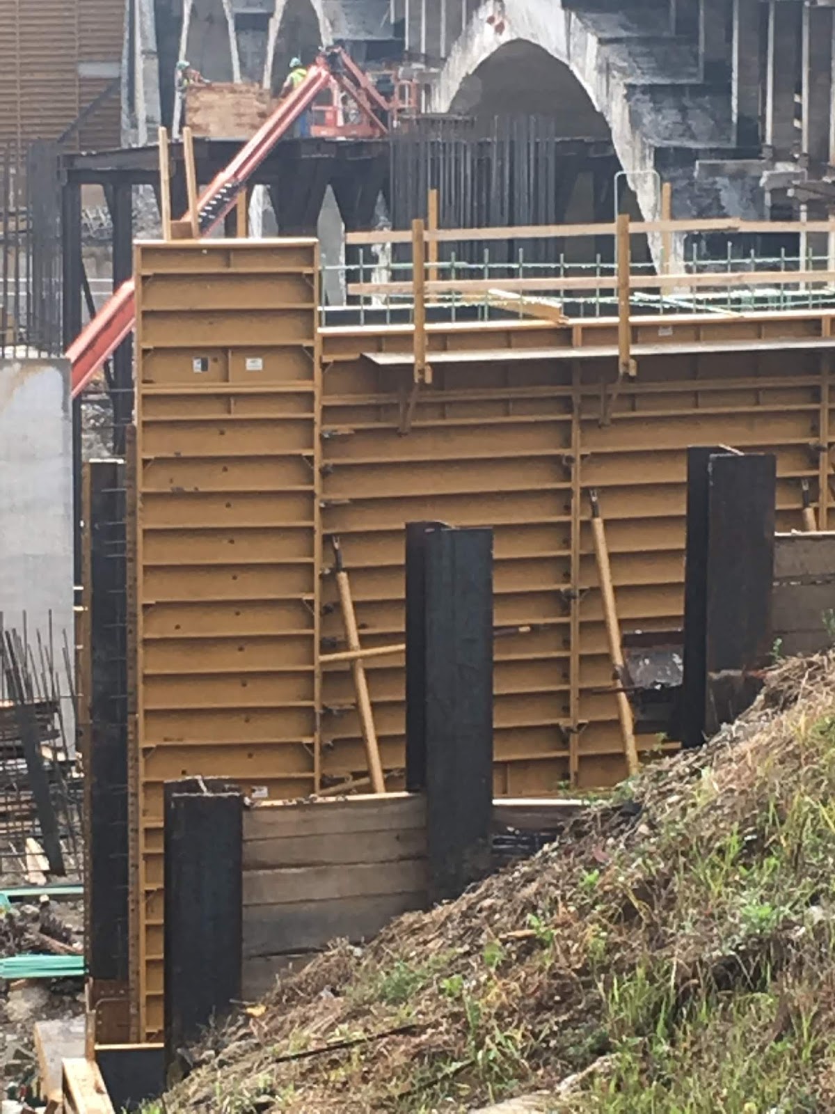 |
| The view from the west shows the back of the western abutment with the pile and lag temporary retaining wall in the foreground and the forms for the concrete wall to be poured further in. The space between those tow would be filled and become the support for the approach slab which will be"hinged" on the abutment |
 |
| The same view as above showing all arches of the remaining span which will be demolished in phase 2 |
 |
| View from the east where the soils behind the temporary retaining wall where washed out |
 |
| The remaining westbound lane has a "bump" on the approach area indicating that some of the supporting soil softened or was washed out |
 |
| Concrete swales were created to catch run-off at the eastern temporary retaining wall but washouts occurred behind the lags. |
 |
| View of the eastern pile and lag temporary retaining wall and how it turns to support the soil under the approach slab of the remaining span where some washout appears to have occurred. |
Updated for sewage spill and additional photos 7/31/18. All photos copyright Klaus Philipsen.
Related article on this blog about the bridge construction work:
Edmondson Avenue Bridge replacement (12/2016)
No comments:
Post a Comment