Friday, October 16, 2020

An overly complicated approach of reinventing Penn Station

Penn Station in Baltimore is an untapped and undervalued asset as I noted before. It is a big deal for Baltimore that it sits on the only high speed rail corridor in the US and connects the center of the city with Manhattan, Philadelphia, DC and the entire Atlantic region.  It is an asset that is not nearly mentioned enough, nor is it reflected in local planning. 

To this day, Amtrak is left to his own land holdings and investment without any supporting local strategies that would elevate the effort and put the Amtrak investment into the proper context. This is in stark contrast to other cities, for example Denver, which has revived an entire city quarter around an Amtrak station that has only two long distance trains per day; or to DC, where also a brand-new development district sprang up around Union Station. Striking in DC, for example: A giant bus terminal on top of the train tracks and a tiny, but very elegant bike parking station that adorned design magazines around the world. More transit oriented development over the tracks is in the planning stage.

Penn Station sits within a sea of nothingness (Photo: Philipsen)

This isn't the situation in Baltimore. While the decades long talk about sprucing up the station and its environs is finally ramping up to become real action, yesterday's presentation to the City design review panel UDAAP proved how hard it is to reinvent the Penn Station area with just Amtrak land, given that the area is currently characterized by vacant lots, parking lots, a sunken expressway, billboards and the small scale efforts of the reviving Station North neighborhood. The only larger investment in sight is the new Nelson Kohl apartment building north of Lanvale Street. The new UB Law School sits south of the JFX canyon. 

The design team of Gensler Baltimore and Mahan Rykiel, selected by developers Beatty Development and Cross Street Partners, presented on Thursday the design of an addition to the station that is proposed for the north side on the Amtrak land at Lanvale Street that is currently a surface parking lot. But when a developer builds a station, then one doesn't just get a public transportation structure, but also a lot of stuff that generates income and makes the pro-forma work. And this presents only the first of a trifecta a problems that make this project so difficult. 

Gensler design proposal for station addition as seen from the southeast
(Screenshot from UDAAP presentation)

Geometry is the second. The tracks don't conform to Baltimore's Street grid but run in an angle. The historic Penn Station is a solitary landmark sitting  diagonally in the urban landscape. The designers decided to get back to the street grid and reconcile the angles in a variety of shapes. A train station also needs visibility and not disappear in a mundane building like the much hated "new" Penn Station in New York that is mostly visible through a large canopy. 

Lastly there is the issue of any bifurcated transportation facility: Where is what? Where is the main entrance, where is the ticket counter, where is my bus, my taxi or my pick up? Today any arriving or departing passenger has only one logical direction to go, the building is super obvious, except maybe for finding the light rail. With an addition which easily doubles the footprint of the station, there are always two ways to go and finding one's way will have to depend largely on signs. 

This diagram shows the geometric and functional
problems of this site (Screenshot)

The design team is savvy enough to understand these problems and covered UDAAP with a flurry of diagrams showing circulation, access points, multi-modal connections and opportunities for creating memorable spaces. There was talk of opportunity for "moving and lingering", there is a "stoop" and a "mixing bowl" and the idea of "trains as theater". The "material palette" of the old station is picked up and also contrasted. All in all there was plenty of that particular lingo that architects apply when things are too complicated to speak for themselves. And that is, in a nutshell, the problem with the design.

UDAAP's reception of the design was friendly but unenthusiastic. Architect Pavlina Ilieva, who chaired the review session, said that the form language of the north [addition] is too confusing vis a vis the clarity of the old main building. She summarized her concerns this way: “What I’m worried about is that, in the end, this train station will feel like .. an extension of the podium of the commercial building and it would never read like a train station". The two commercial towers, jammed onto the same lot as the station addition, and proposed for offices and apartments, were only outlined in the renderings.Their design and construction is supposed to come later. Certainly a dilemma for the review panel which also included architect Anthony Osborne and planner Cheryl O'Neill. 

The view of the historic station how it would present itself from the 
new train hall. (Photo: Philipsen)

O'Neill applauded the "train as a theater" concept and the large glass facade of the north addition which allows a full view of the historic building and the tracks below. Telling an architect that the view of the old building is the best thing his new building has to offer, is probably a double edged compliment. 

Anthony Osborne wasn't convinced about "the handshake" between the old and the new as it manifests itself where the historic concourse gets extended to cover an additional track and lead into the new train hall. His suggestion regarding the "complex juxtaposition of volumes" was to "simplify and not amplify" the complexity. Wise words, however it is a question what the designers can do with this advice, as long has they have to jam that much profitable volume into this limited site. 

Maybe it would be more successful to complement the station solitaire with another modern solitaire on the north lot that can be tall and slender, but does not conform to the edges of the street grid. In such an approach the north station hall would be little more than a connecting element between two solitaires, allowing rear access to the station but leaving all the main functions in the historic building. 
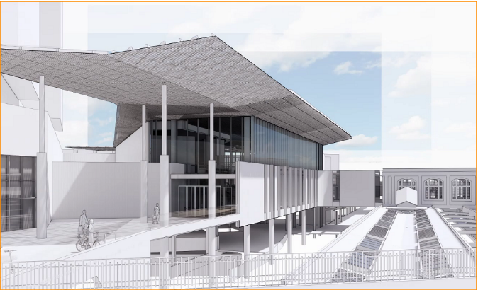
A swooping roof, a large picture window and an unsuccesful concourse 
"handshake" (Screenshot)

The even bigger challenge, though, goes to the City: What will Baltimore do to leverage this significant Amtrak investment so that high speed rail really creates transit oriented development on underutilized lots all around? 

A bigger masterplan also has to tackle the canyon of the JFX that separates the Station from Mount Vernon. Some type of lid seems to be in order. Baltimore's Amtrak station is too valuable to not leverage the opportunity. A new generation Acela trains will whisk passengers north and south in half hour intervalls. That's more often than the light rail that connects the station. 

Klaus Philipsen, FAIA


Pedestrian areas diagram (Screenshot)


Points of arrival diagram (Screenshot)


the historic concourse (Photo Philipsen)

the historic train hall (Photo Philipsen)


Friday, October 9, 2020

A drastically realigned Baltimore

 While Harbor Place announces one closure after another, Seawall reported that 250 vendors have applied for 55 stalls in the new Lexington Market. Does this stand for a new trend?

Indeed, there is also new energy around the refurbished Cross Street and Broadway Markets with people enjoying pop-up outdoor seating on rededicated parking and street spaces. These days, if one wants to meet people in the City one needs to go to the neighborhood "main streets" from Highlandtown to Canton, and from Middle East to Pennsylvania Avenue.  Downtown Baltimore remains deserted.

Seawall says that the want to be Lexington Market merchants are 60% local, 60% women owned

Downtown on Baltimore Street near Charles: 100% corner
(Photo Philipsen)
and 60% black owned, 35% are Asian. Oviously, some are several of those at once. Most of the businesses in the Inner Harbor , by contrast, are national chains. 

Pennsylvania Avenue and other local commercial strips are populated by nearby residents and essential workers getting around by transit. Downtown streets are empty because office workers now work from home and are stuck in the neighborhoods or suburbs. Tourists and conventioneers don't exist anymore, home-bound they, too are now zoomers. 

As in other cases, the pandemic has not created these conditions entirely from scratch but simply accelerated trends that have been in the making for years. 

Haven't people said for a long time that the Inner Harbor was too dominated by national chains to be even considered genuine Baltimore? Hasn't the auto dominance of Key Highway, Pratt and Light Streets created all kinds of proposals to end the grip of those streets that like a vice choke the life out of Harborplace? The mini malls at the harbor have been on the fritz long before COVID.

The internationally renowned Senior Fellow of the Urban Land Institute, Ed McMahon, a friend of Baltimore, told the Baltimore SUN: 

“T-shirts and mugs and crab memorabilia aren’t going to cut it anymore; you have to offer something unique that appeals to both tourists and locals,” Ed McMahon

The gap between relatively strong life in neighborhood centers and the lifeless downtown (and Inner Harbor) has been growing for a while, COVID only put it on steroids.  Office demand in downtown has been slow for years. Downtown residents which have filled many apartments on converted former office floors have never filled the streets as imagined, they can't replace the lunch-time crowds of office glory days, and in the evening downtown has still only little to offer. 

The slow conversion of downtown from work-center
to neighborhood (Photo Philipsen)
Should the accelerated trends persist beyond the acute pandemic, it would spell a new urban concept for Baltimore, always known as the "city of neighborhoods". 

It would be a  multi-nodal constellation with many neighborhood stars and downtown as a black hole, heavy and big, but without lights. In a less stark and more likely scenario, downtown would become just a regular, but centrally located neighborhood. Parts of Charles and Saratoga Streets could act as small-scale commercial hubs, but would not have a regional pull like Baltimore's downtown of the past. 

Such a constellation poses not only brand identity issues for downtown, but also severe economic questions. The old certainty that all neighborhood folks would naturally want to flock to  downtown as the "commons" of the entire region meets would be rendered a memory of a past. The downtown magnet had lost some attraction ever since the grand department stores closed. It was the Inner Harbor witch its tourists and conventioneers that allowed downtown boosters to hang on to the old idea a while longer.  Downtown as a financial and business hub has also faded for some time, with one business headquarters after another leaving. More and more office space became obsolete. 

The uncomfortable truth is that fewer and fewer people have good reasons to come downtown or even to HarborPlace. The notion of the central city as the sun in a galaxy with downtown as its hottest place, has been deeply ingrained in the minds of planners and politicians the world over. Time to replace it with the multi-nodal urban concept which has been present in the minds of regular people ever since they began flocking to the peripheral malls in lieu of the downtown department stores. 

Today only very few US downtowns live up to the image of Times Square in New York or Market Street in San Francisco. Baltimore hasn't had this vitality in a long time and all the heroic efforts have not changed a steady pace of declining importance, neither Charles Center, nor Center Plaza, the Arena, the Convention Center or the downtown sports stadia. The many new boutique hotels have added choices for tourists and conventioneers but their future is in question. The so-called Westside Renaissance ("The west has zest") has never been very zesty, even though large investments were actually made and the area was declared an arts district to boot. What works there is new housing and maybe, the brand-new Lexington Market. 

Nothing to do at the Inner Harbor?
"Urban planning is managing coexistence in shared space, the question is less what a city becomes but who in the city belongs" Julian Agyeman. Professor of Urban Planning, Tuft University

What are the lessons? To whom belongs downtown? What can downtown, the Inner Harbor and the Westside learn from Highlandtown, Remington, Canton, Federal Hill, Pigtown and Pennsylvania Avenue?

  • The central notion of Harborplace as Baltimore's "living room" was to reinvent the waterfront from  a rat infested stinking liability into an asset that neighborhoods could share. It was not to provide a playground for tourists. The initial stores were local and the concept was a marketplace not entirely unlike today's food halls. That original notion is still good, even though revitalized waterfronts have become a dime a dozen. But instead of trending towards homogeneity, Baltimore's uniqueness needs to be brought to the fore. Instead of Cheesecake Factory, Dicks, Ripley's and the awful pirate drinking ship, emphasize Domino Sugar, the view of the Key Bridge, the historic buildings such as the Sugar House and Recreation Pier, fishing and tugboats and the sale of fish fresh from a boat. 
  • The new design for Rash Field, the still attractive five-mile waterfront promenade and improved water taxi landings are amenities foremost for residents of the adjacent communities. This all will be great amenities for some time to come, no doubt. 
  • Let go of the pavilions and concentrate urban retail, restaurants and services around the outer edge of the harbor, across from Pratt and Light Streets. This would visually and functionally expand the sense of place of "HarborPlace" and open vistas of the water.
  • The neighborhood lesson of local retail and restaurants needs to be paired with the other lesson that COVID teaches us: Streets are for more than cars. The take-out food, sidewalk browsing, and the outdoor eating culture need to be brought into downtown streets as well.  
Los Angeles" Transportation manager Seleta Reynolds told National Public Radio's Marketplace host Kai Rhyssdal that in a crisis people have to reposition their assets. She meant LA's Streets, which like Baltimore's, have frequently been re-purposed for outdoor dining, walking, biking and quiet and safe outdoor space in front of residences. 

"Streets are actually public space. They’re just like parks or anything else. We who live in a city, we own them. And when we have a huge moment, like the one we’re living through now, where, you know, small businesses … we could see that they were all struggling. So we decided it was time to think differently about how we use that public space, and instead of using it to store cars, could we use it for restaurants to set up tables, for stores to sell to customers?" (Seleta Reynolds, Transportation Manager LA)

Thus, the freeway style five and six-lane speedways around the harbor would become single loaded urban boulevards with largely unimpeded views of the water. Downtown streets could expand their skinny sidewalks through "parklets" and sidewalk dining. 

To whom belongs the street? Outdoor dining in Fells Point 
(Photo Philipsen)
But the blueprint for a reimagined new spatial concept for Baltimore still needs an economic base. Residences, food markets and sidewalk dining alone are not enough to keep the city afloat. 

What will replace the conventioneers, the tourists and the ballgame crowds? Or even more urgent, what will replace the once dominant feature of downtown, the office? Even if 90% workers would slowly come back, a 10% permanent loss requires creative new ideas for replacement uses. Not to mention the restaurants and hotels which can't survive this coming winter.

Making parts of the old Market Center district an arts district was one of the promising ideas, especially if the downtown arts district would be the one, where all cultures can co-mingle and belong. Downtown can be the place for those ethnic festivals that haven't found a home in the neighborhoods. City Fair once functioned as such. The night market in the former Chinatown area was a big success. Many more sustainable solutions need still to be invented: New retail concepts that, like Apple stores, mix up the concept of sale and museum. Pop up work spaces that allow the type of mingling that some modern creative work requires could replace some corporate headquarters. Co-working spaces are here to stay.

To whom belongs the city?  Becoming vs belonging
(Photo Philipsen)

Maybe some types of clean manufacturing can return to downtown which once was also a center of the garment industry. Modern types of production can be clean, interactive and need no longer be hidden in ugly industrial zones without good access. 

Theaters, movie houses, museums, concert halls and show spaces are already in or near downtown, hopefully they can slowly be nursed back to life as truly regional magnets, possibly combined with temporary or permanent outdoor spaces where art can unfold safely, even in a pandemic. 

There are still more questions than answers. We can be pretty certain, though, that "the good old days" won't return. Given how segregated the city has been to date, a realignment was a necessity anyway.  

Klaus Philipsen, FAIA

Saturday, October 3, 2020

Trash: The moral high-ground vs reality

 Of course, it would be better to recycle than to burn. Of course, dioxins are a devilish pollutant; of course is it reprehensible that incinerators, chemical facilities and polluters are concentrated near communities of low income, that cities are designed so that the poor live downwind from flu-stacks and the rich in the healthier air upwind. Of course, Baltimore is a non attainment area under the federal Clean Air Act and the trash incinerator known as the BRESCO plant (now owned by Wheelabrator) is the biggest stationary pollution source. And yes, air pollution adds complications to other diseases.

Incinerator (Baltimore Brew)

In light of this the Baltimore City Council created its own Baltimore City Clean Air Act that set such strict emission standards for the incinerator that it would have been forced to shut down. The alternative waste concept that the Council created is the Zero Waste Plan, an idealistic goal that is a bit a bit like God stating on the eighth day: "there shall be no trash". It would assume trashy Baltimore to become cleaner than tidy Zurich, Switzerland.

When this attempt failed in court for overreach and Mayor Young began to negotiate with Wheelabrator instead, outgoing councilwoman Mary Pat Clarke's came up with an even more god-like idea. She introduced the “Ban the Burn at Every Turn Act” (bill 20-0615) which would prohibit the City to even negotiate with any incinerator operator. This would prohibit Wheelabrator to entertain a settlement with Baltimore City which would allow some continued use of its incinerator. This bill would lift Baltimore to the loftiest moral high grounds possible. But inevitably, the dank and stinky valleys of the reality of trash. have not gotten any better.  The heroic theater is deeply impractical if one considers these stark realities:

  • the international system of recycling is on its knees, not least since American laziness fed it an unusably polluted mix of stuff resulting from single stream recycling so that China, the main recipient finally said, no more. 
  • the pandemic has put the use of plastic through packaging, online shopping and the use of disposable protective gear on steroids
  • which increased domestic garbage by as much as 30% in cities around the world
  • this, in turn brought Baltimore City's trash collection on its knees for months. DPW has abandoned curbside recycling and is not managing to pick up trash on time once a week in some neighborhoods 
  • trash has now an even more distinct presence in Baltimore alleys and neighborhoods that even in normal times are more trash strewn than those in most cities
Zero Waste is an admirable goal and Baltimore is not the only city to aspire to it. But even for the first steps such a plan needs many pieces to work, even in the beginning when low hanging fruit can be collected. San Francisco which aimed for Zero Waste in the first decade of this century managed to reduce trash by 50% in the first 5 years of its program and has become the Mecca of the US Zero Waste movement. San Francisco didn't believe in magic. Instead it made big investments and created a trash reducing regulatory framework. It bought an enormous sorting machine for recyclables, it banned plastic bags, styrofoam containers, introduced an elaborate composting system and made recycling mandatory. It has a fleet of trucks which collects trash in presorted categories. It all started a dozen years ago. This year should have been the end date to reach the final goal of the 12 year strategy: zero waste. What happened was not linear progress. After the first 4 year success (a 50% trash reduction) San Francisco's trash volume increased again. In 2020 it is bigger than it had been in 2012. The goal of Zero Waste has now been abandoned and a new target has been set for 2030, a 50% reduction of today's waste. 

Most would agree that Baltimore isn't San Francisco, and that goes both ways. It doesn't have to contend with a giant growth wave but it also doesn't have nearly the same resources.

In the short term, incineration or landfilling are the alternative for the trash that has not yet been avoided or recycled. Baltimore's Zero Waste plan recognizes that. Since its only own landfill on Quarantine Road will soon run out of space, the plan wants it expanded. Ironically the landfill sits in the center of the disadvantaged communities that the clean air activists claim are most impacted by the incinerator pollution. A landfill is an environmentally very undesirable way of taking care of trash, even though, it is probably the oldest method. In landfilling heat from the decomposing trash is wasted and methane, the gas that is created when organic matter decomposes, escapes into the air all over the landfill as long it isn't capped, and contributes to global warming. Methane is a many times more potent greenhouse gas than CO2. But exact measurements of the pollution caused by landfills from trucks, methane and fluids that seep into groundwater or the Bay are hard to come by due to the nature of an ongoing spread-out operation.

By comparison, it is relatively easy to determine what comes out at the top of the incinerator flue stack. 
Friends and foes of incineration and cogeneration use incompatible arguments to make their points. 

Wheelabrator says incineration is more environmentally friendly than landfills. The Energy Justice advocates maintain that incineration is the dirtiest way of waste disposal. Hotly disputed is especially the slogan "waste to energy", the practice of using some of the heat from incineration for steam heating or electricity production, a process known as cogeneration. Energy Justice says on its website:
Incineration is the most expensive and polluting way to make energy or to manage waste. It produces the fewest jobs compared to reuse, recycling and composting the same materials. It is the dirtiest way to manage waste - far more polluting than landfills. It is also the dirtiest way to produce energy - far more polluting than coal burning.
The Energy Justice folks make fairly free wheeling assertions, as in their talk about waste and water vapor in this paragraph from their website:
Waste-to-Energy is a PR term. Trash-to-steam is also a lie (there is more in trash than water, thus more in incinerator pollution than water vapor). The reality is that incinerators waste 3-5 times more energy than they recover
Sure, now doubt that producing heat or energy by burning fuel is neither particularly efficient nor is it clean. Incineration creates more toxic emissions than fossil fuel (even coal) power plants, it shouldn't be recognized as a renewable energy, for example. But nobody sees incinerators as great powerplants.
Co-generation diagram

Cogeneration, simply means recouping some of the energy that gets set free when burning trash, either for electricity or for steam. 
Of course, the steam isn't generated from the waste itself! It gets created in a heat exchanger. The idea is to get something useful out of the trash, in this case steam that runs in a district heating system that warms downtown buildings, or runs a turbine to generate electricity. This side benefit can't be all bad. Wheelabrator states that about 65MW of electricity are generated that way, with about 1 MW feeding about 600 homes, this amount could serve up to 36,000 or so homes.  In total the 80 plus incinerators in the US provide only a tiny contribution to power generation. 

One can certainly call "waste to energy" a PR term. However, if waste has to be disposed of anyway, it is probably better to get something out of it than not. 

The opponents of incineration correctly state that most items that make up municipal waste, have too much value to be incinerated. Much could, indeed, be recycled, and much could be composted. But to discuss the matter in extreme terms doesn't lead to a solution.

That is why even countries that recycle a lot more than most States in the US, use incineration for the remainder of their refuse. Sweden burns about 50%. They use better incinerators than Baltimore's aging plant. The City would be well advised to keep negotiating with Wheelabrator about what they can contribute towards recycling, waste reduction, and fewer emissions through the installation of better scrubbers. This wouldn't negate the objective of waste reduction at the source. 

Klaus Phlipsen, FAIA


CityLab article about increased trash
Pro Wheelabrator commentary SUN
Brew article about Clarke bill
Anti Incinerator commentary SUN
Energy Justice website
West Palm Beach modern incinerator

On this blog:

Thursday, September 24, 2020

Rethinking planning in Baltimore County Part 2: The great opportunity

 This is part 2 about re-thinking Baltimore County Planning. Part 1 can be found here

A courageous zoning decision 

In spite of defining the future of 308 parcels on nearly 5,000 acres all over the County for the next four years, the legislative Tuesday session of the Baltimore County Council on August 25 was as tedious and obtuse as it can get.

Baltimore County CMZP dashboard 2020

And yet: About 180 citizens had clicked themselves into the WebEx conference call to listen for two hours and 20 minutes council-members read out numbers. Those were the zoning case numbers, district by district called up and bundled first into the group of those in which the councilperson agrees with the recommendations of the Planning  Board followed by the group where they wanted to deviate from the recommendations. Each time a roll call. Each time unanimous approval.

No debate, no questions. Some of the cases represented years of local debate, but one wouldn't know that. When it comes to zoning, no council person will ever question another one's decision in their district. To decode what was going on, participants needed the "log" of zoning issues, online maps and a good knowledge of their community. Such is the County's quadrennial CZMP, a sacred and unique cow of this county's planning since 1969. One can safely say, that the arcane process does not lead transparency, even though a new dashboard made the overview a bit easier this year. The process also doesn't lead to a more comprehensive picture in which the composite impact of individual decisions would be a decisive factor in any way, even though the dashboard does provide this aggregate view.

Without all those documents nobody could tell the importance of what happened an hour and fifty three minutes into the meeting: Current Council Chair Cathy Bevins came to her own district six. She delegated the read out of the cases to the Council's Secretary Thomas Bostwick, the only participant who actually sat in the Council chambers in Towson. At 1:54.30 issue 6-004 was called up, Bevin's first case where she recommended something different than the Planning Board for no less than 430.45 acres in Middle River, about 60% of the entire land area she had to consider for zoning changes. At  exactly 1:54:30 into the meeting the roll call and another unanimous affirmation, this land owned by a global conglomerate had changed from "industrial" to "Resource Conservation" zoning, RC8, limiting use to very low density residential (See Citizen Zoning Guide). 

Baltimore County and the URDL

This year, when Baltimore County has to start a new 10-year plan for the entire County, I will use this decision as an illustration for how Baltimore County's Planning could advance from incremental, piecemeal, reactive and extremely local thinking towards a more comprehensive, audacious, forward looking and sustainable approach. In other words, towards a comprehensive masterplan that deserves the name that really can be used to guide the next ten years.  


Nowhere is a bigger need to look at the larger context

Here was not only a large swath of land but also a case where a council member mustered the courage to stand up to economical interest, and decide against the interest of the property owner, the recommendations of the County Planning Department, and the  Planning Board; instead she opted for the wishes of  a community initiative

The MD 43 corridor and the LaFarge site

This decision is also big for the strategic location of the land: Located just inside the growth boundary URDL and between the Bird River and the Saltpeter Creek the land is is important for its environmental potential. But it is also located near the MD 43 growth corridor, which includes the following elements
  • Baltimore Crossroads, a 1,000 acre masterplanned, mixed-use community which includes the 200 acre, 1700 unit Greenleigh residences.
  • a MARC commuter train station, 
  • a 747 acres large State run airport,  
  • the 50 acre former Middle River Depot site where Glenn Martin once produced bombers B-26 bombers in the State's largest industrial building (2 million sf)and 
  • the 338 acres site of the shuttered Lockheed Martin company.  
A history of sand and gravel

Mining was once an important industry in Maryland and sand and gravel mining still is. In 2017 there were still 361 mines active in the state, many surface mine sand and gravel, ingredients necessary for road construction and concrete. Genstar alone owned over 3000 acres in Maryland in 1995. Since then the company has been bought by Lafarge, a French company with headquarters in Paris which in 2015 merged with Holcim, a company with 70,000 employees in 70 countries. Today LaFargeHolcim still lists 20 active sites in Maryland which make cement, concrete, asphalt, or aggregates. Crushed stone and sand are still in high demand, even if many Maryland mines are exhausted, have been filled, paved over and have reclaimed for new uses such as the Greenspring Quarry that is now a new gated development with a lake. In 2019 Maryland still produced 32 million metric tons of crushed stone alone, valued at $411 million. Sand and gravel operations enabled White Marsh town center, the Honeygo Reclamation Center and is the former use of the former Chase Plant at the rezoned Middle River site.
View into the LaFarge/Glenstar Chase site
(Photo: Philipsen)


Before the zoning decision the giant former gravel and sand mining area had been largely zoned Manufacturing (M), either designated as H for heavy or L for Light with some tiny areas of RC3 and RC20 zoning. It is safe to assume that the County's development boundary was drawn around the gravel mine. One of the flaws of Baltimore County's zoning in regard to mining is that the zoning persists, even when a mine is closed. This is a big problem since mines are usually not located where other industrial uses would make sense. It shouldn't be a foregone conclusion that mining companies should eventually turn into big land developers. Instead, it would make a lot of sense to revert mines into the public domain with strict oversight of the mitigation of environmental damage and eventual reclamation plans. The zoning category Cathy Bevins voted into effect is RC 8, which means Resource Conservation designated for Environmental Enhancement.


What "real planning" could mean

The Planning Departments review of a "concept plan" submitted by LaFarge this summer suggesting industrial warehousing on the precious land is not reflective of a department that looks at the bigger context. Granted, Lafarge utilized the County's zoning loophole to consider the proposed use as "by right" under the ten still applicable zoning. Still, while the County Planning Department gave that idea a tepid review, it didn't say outright that it was bad, even though lack of water and sewer, lack of transportation access and the location in an environmentally sensitive area should make it obvious that warehouses are a bad idea. The current fill with operation with an endless convoy of dump trucks navigating a circuitous route to and from the site makes the lack of road access obvious. The fill operation creates substantial revenue through tipping fees for the site owner, so its not that they have a site with no revenue. 

What was also clearly missing from the concept plan review, is the larger view that the Essex Middle Ricer Civic Council (EMRCC), an umbrella group representing over 20 Community Associations, when they applied for the RC 8 zoning. At a minimum Planning should have tabled the concept plan review until after the zoning decision. The broader view is well represented in an article in the Avenue News. referring back to the current 10 old Masterplan they write: 

In 2010, Route 43 was not completed, the Federal Depot’s (2,000,000 Sq.Ft. building on 56 acres of developable land) future use was undetermined, and the mixed use development along Route 43 was not envisioned. Since that time, Crossroads at 95 and Greenleigh have surfaced with major integrated mixed use and intense development is in the works for the Depot Building and its surrounding 56 acres. 
Additionally, the Lockheed Martin property, with several large structures, sizable open space, and vast waterfront has been environmentally rehabilitated in preparation for redevelopment. These developments are more than sufficient to meet the areas current and future [development] needs. (The Avenue News)
Crossroads and Greenleigh plan (Design Collective)


In the context of how the County can reposition itself in the post-industrial reality of a location between Baltimore City, Anne Arundel, Harford and Howard Counties the east side of the county holds enormous promise. 
"Essex and Middle River are the most important areas in the County" (Bob Bendler, President EMRCC) :

This optimistic outlook is only justified if the growth and development nodes from Greenleigh to Lockheed and from LaFarge to the MARC station are  looked at comprehensively and not one by one as has been the case so far. 

The loss of development area on the LaFarge site should not been viewed as a loss of economic development opportunity but as a lever that can add value to every development in the vicinity. In the post industrial world environmental amenities, available recreation and good planning are prerequisite that a highly mobile workforce is looking for. That means that even the owners and developers of the Lockheed site, the Depot site and of the still growing Greenleigh "new town" would benefit if a strong environmental and recreational corridor would emerge all the way from the Bird River to the Middle River and Saltpeter Creek. The COVID pandemic has highlighted the importance of parks and open spaces more than any other event before. Climate change will make sound environmental planning ever more important, especially in the low lying waterfront areas like those in Middle River. The LaFarge rezoning allows the application of sustainability principles both in environmental  protection and economic development.

In a letter that I wrote to the Planning Director on behalf of NeighborSpace in this matter I pointed out that"

The site is near the White Marsh Boulevard area which was initially conceived as an important connector with vast opportunities for industrial development and uses that would benefit from easy access to I-95. As we know, the development
along White Marsh Boulevard has taken a very different turn. The corridor increasingly features mixed use and residential development, some arranged using some New Urbanist features. The proximity of a growth corridor next to a
resource conservation area creates conflicts and opportunities. To date, developments in the MD 43 growth corridor occur piecemeal, remain isolated from each other, and don’t add up to a larger pattern that would ultimately create a real community or optimal value. In that, they are a far cry from how Columbia or Maple Lawn were or are being developed. (NeighborSpace in a letter to the Planning Director)
Lockheed Martin and Martin Airport site map

So how can the decision for Resource Conservation zoning help in repositioning Baltimore County?
  • Open space, recreation and access to water have been value creating elements around the country. Nearby Gunpowder State Park and the existing Marshy Point County Park could be significantly enhanced by a connection to the Bird River and a much enlarged protected watershed
  • If properly connected, a regional environmental protection and recreation zone can bring additional value to the developments that have sprung up without a bigger connective plan. Here is a unique opportunity to make new greenfield developments such as the Arbors and the quite large Crossroads/Greenleigh development more meaningful. 
  • With a proper circulation network a small attractive new town could emerge here that has a train station, an airport, new neighborhoods and precious waterfront access. 
A warning example of how not to operate is the missed opportunity at Owings Mills. The so far less than convincing new town had another shot at becoming truly spectacular when three huge development opportunities presented themselves all generally within a similar timeframe: 
  • The Owings Mills Metro Town Center transit oriented development, 
  • the redevelopment of the failed Owings Mills Mall and 
  • the redevelopment of the former Solo Cup industrial site 
But these three sites where never seen in context or as a single challenge and opportunity that would define the future of Owings Mills and present the maybe last chance for Owings Mills to ever become the true new town it aspired to be. Instead of creating synergy, the sites were each developed without consideration of the other (let alone proper connections). As a result that all three sites are competing for the same shrinking user pool of occupying retail and office spaces. Even individually, none of the three sites is exceptional, not a trace of the creative spirit that guided Jim Rouse when he developed Columbia and had the California architect Frank Gehry design the Rouse headquarters at lake Kittamaqundi.  
The MD 43 growth corridor cannot be discussed without recognizing that it terminates at Eastern Avenue at the current MARC station. This makes the terminus an ideal transit oriented development site (TOD). No such plan exists, however, and won’t come about without a clear vision that gradually eliminates some of the barriers that current industrial uses present. Existing large historic factory buildings [the Depot] present an excellent opportunity for future connective and attractive mixed use. Past problems with the reuse of this site show that a desirable future will not come about without incentives and the guiding hand of County Planning. (From the NeighborSpace letter to the Planning Director)
The new 2030 Masterplan that will be initiated this year and a from the ground up review of the 13 year old Middle River Community Plan need to take this bigger perspective. 
Environmental corridors and growth areas (Klaus Philipsen)

The synergy potential between the thousands of acres of development areas at stake in Essex/Middle River is huge. A well organized umbrella organization for community participation exists and so does a Roundtable for the MD 43 corridor which brings together the various stakeholders, including LaFarge. It will take now the County to step up with "real planning" to realize it. 

Real planning is proactive, comprehensive, data and community based and integrates small area plans within a larger vision for the County. And, as I laid out in part 1 of this article, it also considers how watersheds, roads and other natural and manmade infrastructure work beyond council districts, planning area boundaries and even jurisdictional boundaries such as those between City and County. 

As the URDL of the 1970s, the County Masterplan of 1989 and various community and open space plans of that period, such as the Open Space Plan for Owings Mills of 1995, prove, "real planning" and community participation is not new to the County. It just has been abandoned somewhere along the way. 

Klaus Philipsen, FAIA 

Friday, September 18, 2020

Rethinking how to plan Baltimore County

The city versus suburb cliché is obsolete

The scare of the "Democrats taking your suburbs away", is a recast of the past using a binary that isn't accurate any longer. What worked in 1948 when the majority voted for in referendum for a law by that blocked the City from further annexations and growth was based on fear of the "other". The original result that Baltimore County flourished and Baltimore City was hobbled and wilting isn't the whole story any longer either. Yes, Baltimore County came out ahead:
  • County Living (Photo: Philipsen)

    With over 827,000 residents the County is now 200,000, or 35% larger, than the City it surrounds.  
  • The County is still growing in population while the City continues to shrink  
City Living (Photo: Philipsen)

But the County is no longer just a bedroom community, and the County has long incorporated "the other". It has become a place of employment (370,000 jobs,about the same number as the City), a place of shopping (to such an extent that many surplus shopping centers sit abandoned) and a place of ethnic and cultural diversity.
In recent years the benefits haven't been so clearly lopsided any longer:
  • While the City loses poorer minority residents and gains affluent, young white residents, trends in the County's population have been the inverse.
  • While the City clearly has large areas of neglect, it can boast big swaths of glitzy new apartment buildings of a quality and rent level unmatched by the County. All the while the County's aging inner ring suburbs are exhibiting some of the same issues as  poor city neighborhoods: sinking property values, sinking school performance, rising poverty and rising crime. 
  • The County is no longer the place of single family homes. Of the nearly 1400 housing units constructed in the County in 2019, nearly 1400 over 60% were apartments and townhomes, only 39% were detached single family homes. 
  • Gone are the times when there were endless forests and pastures just waiting for their last crop: development. For a long time green field development boosted County coffers, but the land area doesn't grow while the need for open space grows with the population, particularly during a pandemic
  • Suburban offices parks and endless run of the mill subdivisions are no longer what people aspire to. Highly mobile employees and residents want urban amenities, active lifestyle options, arts and culture, authentic communities and attractive housing.  In national comparisons iBaltimore County has little development to offer that meets those criteria.
All this is important to consider when Baltimore County begins its new masterplan this year.  The 10 year old Masterplan 2020 "expires" this year. Other aspects to consider:

Baltimore City is now a partner for the County, not an adversary

The first innovation is to look at City and County as partners and not as competing adversaries. The new County Executive has begun that approach already, realizing that infrastructure systems such as water, sewer, electric, roads as well as natural systems such as watersheds and rivers don't recognize the artificial boundaries between jurisdictions.  City and County share the water, electric and transit systems, they share a trash incinerator and many amenities such as parks, museums, theaters and performance venues. Most cities and their counties are long managed together, Baltimore's unique position as a city without county must be mitigated through collaboration. I wrote about this partnership here.

Baltimore County's regulations are obtuse and often antiquated

Baltimore County just finished the quadrennial rezoning bonanza known by land planning geeks under the klutzy acronym of CZMP, which stands for "comprehensive zoning map process".  Unlike other jurisdictions who allow an application for rezoning at any time (usually after masterplans are completed) the CZMP allows rezoning only every four years. The promise is that this allows a more rational and comprehensive process. But that is theory. The reality is different. The all at once approach overwhelms citizens, elected officials and land owners alike. Back scratching, returned favors, convenience and falling for those who make the most noise is common. Thanks to "councilmanic courtesy" which de facto gives each council person the sole say in  their district,  zoning decisions are made with no regard of the cumulative effects beyond a
Urban rural demarcation line (URDL)
(Photo: Philipsen)

district.  The system makes council people a great target for "buying" their decision through campaign contributions and the like. Many Baltimore County residents have lost confidence that land use and zoning decisions are made in a fair, equitable and transparent way or in the best interest of the common good. The development community is rather small and the playing field is tilted towards those who know how to play the dense and arcane regulations that are hard to follow even by experts.

The cheap money no longer flows

Suburbs in general relied for too long on the money stream derived from paving over fields and forests, an approach which some call a Ponzi scheme in which old obligations would always be paid by adding new stuff. Any Ponzi scheme is doomed to collapse once the stream of new money ends. For funding through sprawl, this means when when cheap development ends because land runs out or someone pulls the  plug on sprawl, the party is over.

To be clear, Baltimore County recognized the pitfalls of sprawl earlier than most anybody in the country when it decided in 1967 to protect large swaths of its rural lands mostly in the "North County" by enacting a rural-urban development boundary (URDL). It also designated designated growth areas where development should go, namely the "town centers of Owings Mills and White Marsh. Today almost 90% of all residents live inside the growth boundary, on about one third of the County's total area, a fundamentally sound result, but obviously the well of cheap land runs dry earlier with such a boundary. 

Focus on the inside of the growth envelope

The reflex should certainly not be to relax the boundary so the non sustainable pattern of paving over more and more land can be continued for a while longer. This would not solve the problem just make it worse, especially since discerning residents cherish protected natural resources and open spaces more than ever.  The economic problem the County faces isn't caused by the URDL but by the fact that the idea of "town-centers" was watered down from the beginning. In fact, the County never managed to create anything even deserving that name. Neither White Marsh nor Owings Mills look any different than most ordinary subdivisions, both neither have an identifiable center nor would anybody call them a town.  (I wrote about the problems of planning around Owings Mills here).

Moving forward, the new masterplan for Baltimore County must focus on how development is organized inside the growth envelope. This is not a new idea. Several administrations ago Revitalization Districts were designated and supported. Several of these areas are recognizable older communities and have turned the corner. Still, folks who live inside the development envelope continue to resist what they consider "jamming" more folks into the same areas. Crowded schools, demographic changes, flooding and increasing traffic are easily pinned on new development, when, in reality, the patterns of sprawl are the real culprits. It is thoughtless growth and neglect of  obsolete older commercial development that makes areas unattractive and depletes the tax coffers without creating much new actual value. 
Owings Mills town center (Photo: Philipsen)


For a long time the County was caught in the idea of low taxes and austerity, but austerity rarely is a path towards prosperity. Austerity policies lack the bigger picture investments that are needed to keep older areas attractive. Baltimore County not only lacks the lovely intact historic districts, parks and institutions of the City, it also failed to make the the bigger renewal moves which the City engaged in, such as the Inner Harbor, or the many attractive adaptive reuse projects that converted old industrial areas into attractive mixed use communities (Example Clipper Mill). To this day, the County also lacks creative, innovative housing such as the suburban deck townhomes that the internationally architect Moshe Safdie designed for Baltimore's Cold Spring in 1976. All of new development in Baltimore County  seems to know only one single "style": Neo Colonial, be it for single family homes or for the ubiquitous townhomes that are spread all over the landscape as if someone had broken up city streets and thrown them over the fields and forests of the County.

There was no lack of attempts of creating something like the Inner Harbor in Baltimore County. At the Lockheed Martin Site in Middle River, and also at Sparrows Point or Fort Howard. But each time pragmatism  gained the upper hand in the face of recessions and small doable incrementalism got the upper hand. This is not to say that these opportunities don't still exist, just to point out, that in neither case exists an inspiring masterplan that would ensure that the full potential of tehse wonderful sites would be truly realized. 
Inner Harbor (Photo: Philipsen)


Timidity can't be a sustainable long-term strategy for a County that is hemmed in between the City and the thriving Counties of Howard, Anne Arundel and Harford which boast nationally known historic towns such as Annapolis, or innovative new towns such as Columbia. Unlike Owings Mills, Columbia continues a course towards becoming a real town. Baltimore County also lacks or trail blazing masterplanned new communities such as Maple Lawn or transit oriented development nodes such as Odenton.  The new County Executive already has abandoned the strict austerity course and laid the groundwork for strong investment in schools and education. The COVID-19 pandemic may give the suburbs a momentary leg up compared to the large cities, but sound future planning needs more innovation than "not being the city".

What can be done? This article will be followed by an example of opportunities that are available now  and would allow the County to catch up in placemaking, innovation and sustainable development inside the URDL. The sequel will begin with a courageous decision of a County Council member who mustered the courage to stand up to established economical interest, powerful donors and decided against the interest of a property owner and the recommendations of the County Planning Department to go with the request of  a community organisation and vote for a sustainable future of 450 acres of land.

Klaus Philipsen, FAIA

The date noted for the creation of URDL was corrected to 1967 on 9/23/20

Wednesday, September 9, 2020

Ideas how to draw people to Baltimore during COVID

The other day I placed two photos showing a boarded Visitors center and an empty promenade side by side with the caption "Baltimore isn't open for visitors and nobody is coming either". I caught a lot of flak for that. Baltimorean's are quick to defend their city, no matter the usual griping. That's a good thing. This article tries to develop some thoughts what could be done safely in Baltimore while highlighting the City's many assets.

Here a detailed Facebook comment that contains such a good list of suggestions that I repeat it here in full length:
the post that received the push-back
The Inner Harbor is beautiful in many ways without the crowds and the open commercial establishments while taking a leisurely walk around the area, but Baltimore City is more than the Inner Harbor just look around you at the wonderful museums, the different style of architecture that exists in the city and one moment you can be in France, another Germany, another the Netherlands and the all typical American representing the groups of individuals who live and lived here. A walk around the Walters looking at the Bayre Sculptures is a trip to France and the Anderson building just north of the sculptures is absolutely amazing. Lexington Market is now open and a treat to go and visit and try some typical Baltimore food. A visit to Poe's grave is a treat to see and learn of the history, as well as trip to the Hopkins campus, the Loyola campus so you don't just have to judge the city on the Inner Harbor when there is so much more to see in this beautiful city of ours. We all need exercise and with our masks on we can walk around and marvel at the sights unfold from one street to another. (Christian Wilson, a born Bostonian)
While it is true that Baltimore has many dormant treasures that wait for discovery, passively waiting for people doing the discovering may not be enough to avert economic calamity. I tried to establish some context for my post by observing how many visitor repelling things come together at the Inner Harbor:  the "visitor center closed, the
Construction at Rash Field, Constellation Pier and Visitor Center
pavilions decimated, Rash Field closed, the Constellation docking place closed, the water taxi limping on minimal or no service, Barnes&Noble to be closed and no Conventions, no book festival, no Light City, and empty hotels make it hard to see how the area can be attractive. But that drew only more criticism: After somebody drew the scary comparison to San Francisco "according to friends who live in San Francisco, it's more dead than Baltimore right now". Facebook friend  Vickie Gray added:
Yes, and I don't see how posts like this are helpful. We all know Baltimore is taking a beating from COVID and other events. I and others frequently find ourselves defending our choice to live in the city. I enjoy Klaus' writing and perspective very much but would love to see less doom and gloom and more objective analysis. Articulate, thoughtful people can do a lot to lift the mood of our city and our people. And it's a beautiful September day. I am thankful to live here.
The  honey her post included made the criticism sting even more. True, constructive ideas would help. Especially when so many venues, restaurants, artists and retailers fight for survival. 

Another Facebook comment was another ode to the promenade:
Water taxi landing in Locust Point
I walk the promenade most days, often 5 miles round trip. It is usually very lively and over the weekends packed. Whenever I am feeling down about our great city all I need to do is walk. It is a constant source of positivity. The extent to which the promenade has grown as a place for recreation in the face of covid is extraordinary. Locals, visitors, strollers, scooters, walkers, joggers, as well as kayakers, stand up paddle boards- and now turtles, blue crabs, osprey, heron etc etc in abundance. Klaus- the glass is way more than half full. Add some rose color to your lenses. (Bill Pencek).
Another Facebook friend noted:
Glass half empty is Harbor Place, B&N......Glass more than half full is development has encircled the harbor for miles in both directions from Silo Point /Anthem House to Brewers Hill with multiple new projects every year making a better urban experience and providing many jobs during construction and after.

Couldn't Light City be Covid themed and safe?
This is all true, yet I feel that after the first shock of COVID Baltimore could be a bit more proactive in playing its assets up. BOPA's webpage lists only what is NOT happening. Visit Baltimore's webpage still list the long gone restaurant Week as an attraction and otherwise promotes virtual visits as if the entire city was still in lock-down.

Thinking about how to make Baltimore attractive through COVID safe offerings isn't just about tourism. It is also about allowing residents to come out of their isolation and counter the idea that cities are inherently unsafe places in a pandemic. It is about saving small local businesses from extinction. And by saving businesses and venues from going bust, it is also saving Baltimore's budget from sinking into an abyss. The DOT installed Slow Streets and the many new "parklets" on city streets are a great start.

Much what works in small towns and suburbs can work inside a bigger city as well. So here some additional thoughts:

  • Certainly visitors that want to go to the visitor center should be greeted by a sign that indicates where information can be had while the center gets its makeover. 
  • Certainly the many new pop-up outdoor dining spaces could be highlighted. With so many outdoor spaces created on parking lots and street space, dining in Baltimore can be safe and enjoyable and should be promoted as a new attraction.
  • Certainly the artists suffering from closed galleries, museums and performances could be invited to help put together COVID-safe cultural events.  Light City Baltimore under Corona conditions could be much more than a copy of what light shows have done elsewhere.
  • For example, instead of just cancelling Artscape and Light City wouldn't it have been exciting to have a call for ideas for safe and appropriate versions of these events under COVID? 
  • The BSO, in trouble before COVID  had toured unusual venues such as the Baltimore Museum of Industry and the New Psalmist Church. With COVID, couldn't that idea be expanded to outdoor concerts in public spaces? Could be the example for the ballet, theaters and art to use the great outdoors as long as outdoor activity is still possible?
  • Bengies, an old style drive in movie theater in Baltimore County was sold out during a recent showing. Couldn't temporary drive in movie shows be installed at Mondawmin Mall or the stadium parking lots? 
    Sandlot at HarborPoint is at least as safe as Ocean City 
Staycation is what most people do. Parks and beaches have drawn so many people that the trip back over the Bay Bridge on Labor Day took hours of wait in an eight mile back-up. Baltimore has its own beach, Sandlot at HarborPoint. Its website doesn't mention COVID with a single word. Couldn't Baltimore advertise its beautiful parks that compared to Central Park in New York languish most of the year. A sculpture exhibit in Druid Park? The Zoo had the right idea with a drive-through promotional event, couldn't something like that be expanded to the entire park, maybe eventually without the car as extended PPE? What about all the food trucks that certainly also suffer from the lack of people downtown and the cancelled events? Why couldn't a food truck event in Druid Park, Leakin Park or in the parking lot of the M&T Stadium be made safe? Aren't food trucks extremely adaptable to the conditions under the pandemic? 
Winands Meadow at Leakin Park: Inviting but empty

Black Lives matter demonstrations and associated street art and murals have shown that the streets can be taken back from cars and the lock-down alike without creating dangerous virus hot-spots and that outdoor gatherings in the city can be organized safely.

Finally, the Promenade that started this article. Five full miles around the Inner Harbor are, in my opinion, way more interesting than the boardwalk in Ocean City. Why not advertise it and bring food-trucks, outdoor music and buskers to it in a coordinated big effort to draw visitors and make it safe at the same time?

Klaus Philipsen, FAIA
The carousel taken away from the Inner Harbor has built in social distancing

Center Plaza in downtown has built in social distancing 

Food trucks can be safe during COVID

McKeldin Plaza has built in social distancing

New outdoor eating opportunity, Harbor East

New outdoor eating opportunity, Fells Point

New outdoor eating opportunity, Fells Point

Miles of  new "slow streets": Opportunities for outdoor activities

New outdoor eating opportunities Federal Hill

Safe baseball practice: Locust point

View of downtown from Carroll Park
Curtis Bay Park: Inviting Social distancing events