Wednesday, March 31, 2021

Keough High: From Holy to infamous to banal - Is it inevitable?

The BBJ reports that the former Seton Keough High School campus located smack at the exit ramps from I-95 to Caton Avenue could soon be home to warehouses and distribution facilities under a plan by MRP Industrial. At stake are 43.5 acres (including two out-parcels) that have a combined assessed value of over $15 million.
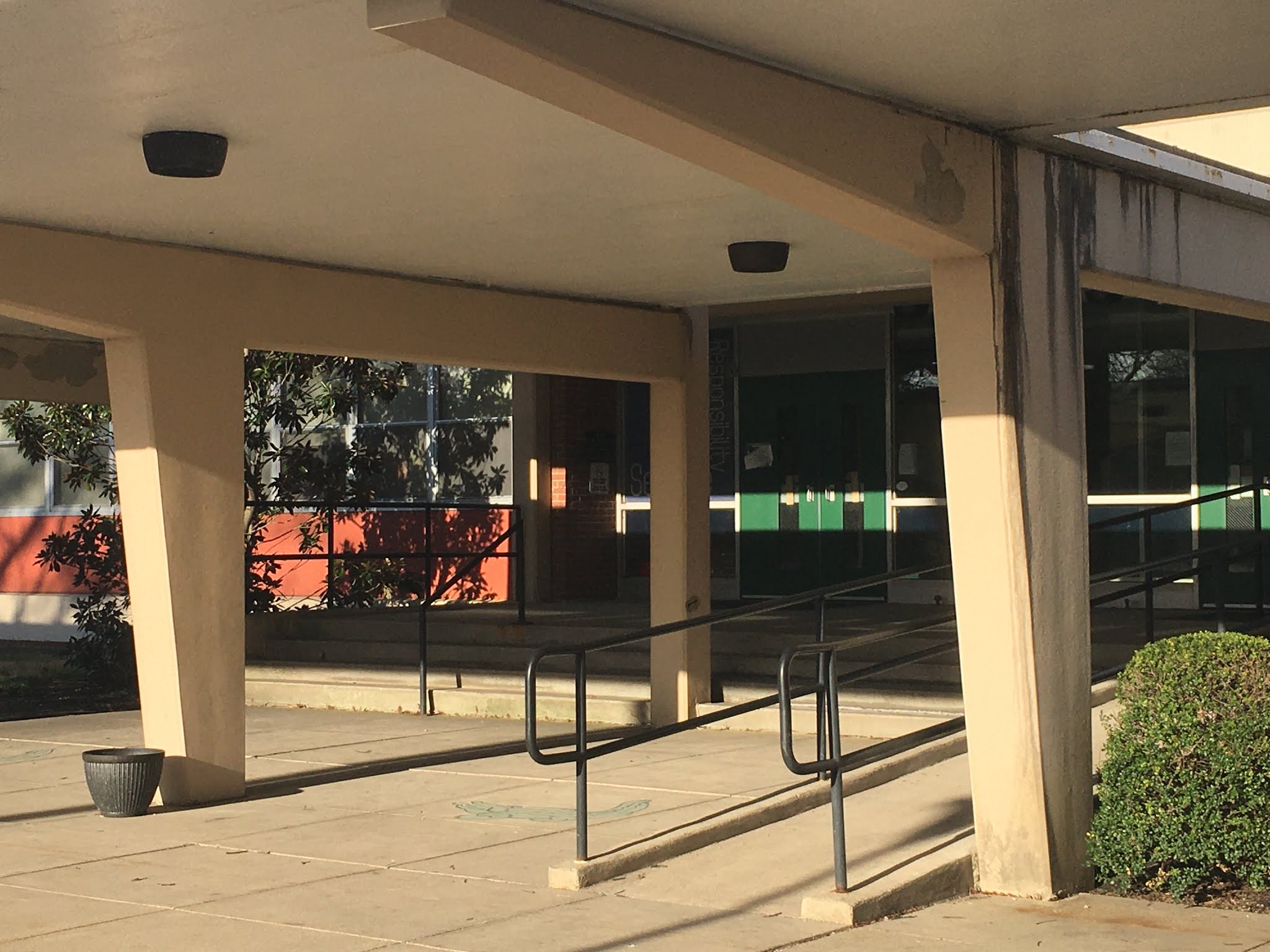
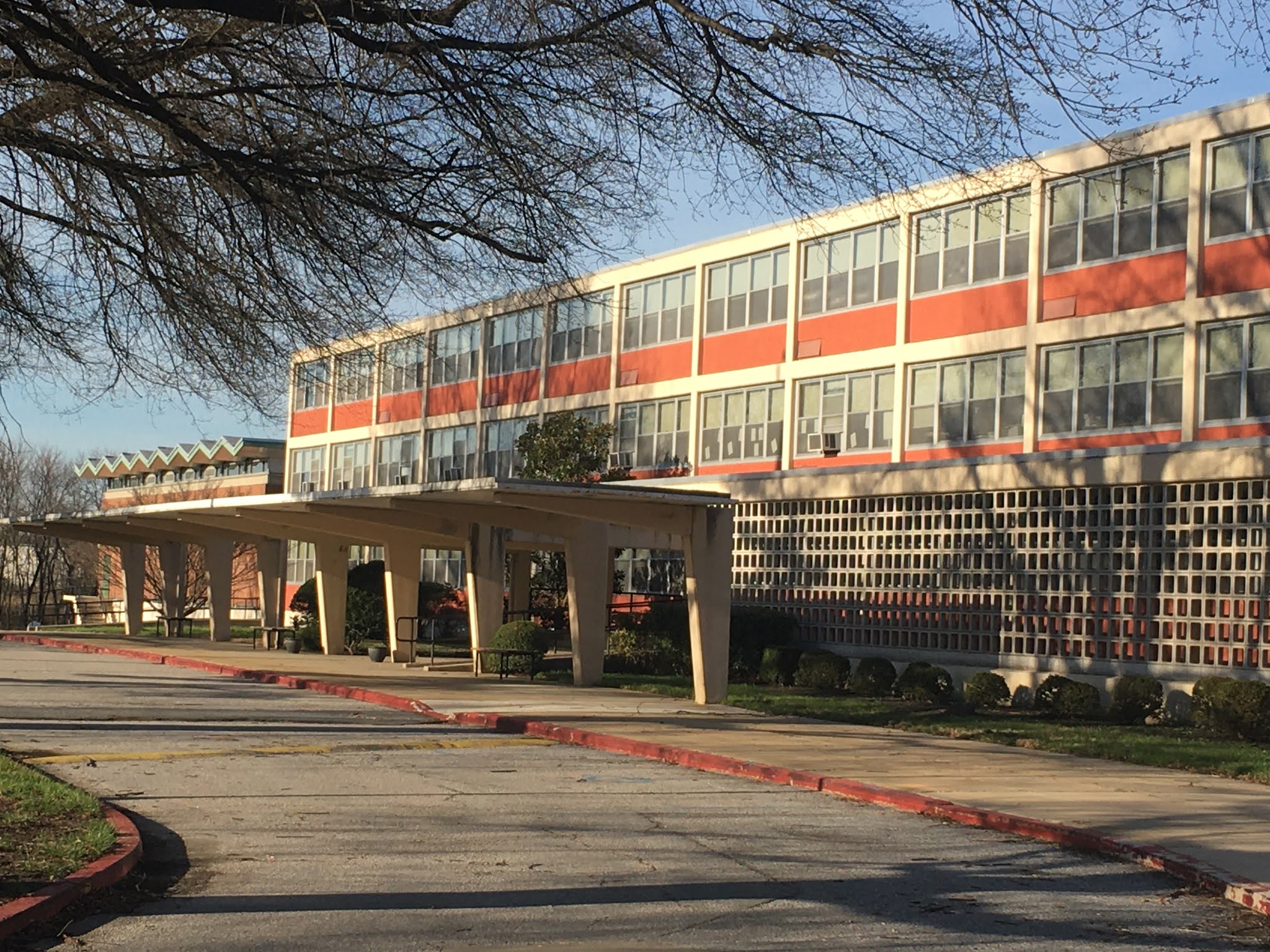
From holy to scary to banal: Holy Angels Keough school (Photo: Philipsen) 


The all girls high school gained dubious fame for its role in the abuse documentary "The Keepers". The catholic school also made headlines when its closure was announced by the Archdiocese of Baltimore in 2016.  The SUN wrote about the Archdiocese's decision to close the school:
Among the affected schools, Seton Keough High School in Southwest Baltimore is likely to attract the most attention. It was formed in 1988 after the merger of Seton High School and Archbishop Keough High School, two all-girls schools that once boasted enrollments of more than 1,000 students each. Seton Keough now serves 186 girls, which limits the opportunity for the kinds of educational and extracurricular opportunities that would be available at a larger school. (SUN)
This shift from the holy to the scary to the banal would seem like a logical thing, since distribution warehouses along major transportation arteries are a hot thing in the northeast real estate market, while large Catholic girl schools in shrinking Baltimore, well, not so much. 
The setting from the north with the school complex on the
left bottom quadrant of the I-95 interchange (Google Earth)


But a closer investigation requires more complexity than just holding a finger into the air to check from where the market winds blow. 
  • Baltimore is famously a landlocked city, i.e. it has no space to grow, in fact, the City is even  prohibited by Maryland law to annex any land from the surrounding County. In light of this predicament, one has to wonder whether space consuming low labor distribution is really the right ticket for a strategically located 43 acres site in post industrial Baltimore. 
  • Baltimore has committed to sustaianbility, livability and equity including all aspects of combatting climate change and environmental degradation.  This begs the question if a largely green and wooded site which is traversed by a stream doesn't deserve more consideration than what may fetch the highest price for the land in the moment
  • Baltimore is known for its historic architecture. The about 60 year old school is a formidable example of mid-century modern architecture with some considerable qualities that only now start begin to be appreciated by the general public.
  • Baltimore has committed to improving the quality of life in its disinvested communities. The small residential pocket communities  of Violetville, Wilhelm Park (of which the site is a part) and Morrell Park, the latter located on the other side of Interstate 95 surround the Keough site all could use a shot in the arm; they especially need to be freed from the isolation imposed by the Interstate, Caton Avenue, the large St Agnes Hospital complex and the industrial uses that keep expanding in the area, including warehouses on Desoto Drive to the east. Those probably represent a precedent for the imagined new use of Seton Keough High.
But these larger aspects are not on the horizon of the current decision making process which is focused on the fact that the land isn't zoned industrial and would need to be reclassified for warehouses. The existing uses in the area provide an eclectic mix of precedents from the St Agnes hospital complex to the warehouses to the traditional Baltimore neighborhoods with rowhouses and alleys. Even a conversion of a former highschool (Cardinal Gibbons) into a mixed use center (Gibbons Commons) is planned next door. This reuse of a former high school presents a far better example than the nearby warehouses.

However, the future viability of the nearby neighborhoods with a median home value around $64,650 (Live Baltimore) doesn't seem to be on the radar this time. Not on the radar either any type of network plans: For example, how the communities could best benefit from the Gwynns Falls park to the east and the Carroll Park Golf course, elements of  the much touted Baltimore City "Green Network Plan", a work still in progress. 
Zoning Map, the pin shows the EC-1 property (Baltimore City)


Morrell Park had been in the news when the Port of Baltimore and CSX considered Intermodal Container Transfer Facility there for containers be loaded from trains to trucks to avoid the low Howard Street tunnel. After massive protests MDOT withdrew from the project in 2014. The SUN reported that "the Morrell Park facility would have been served by about 150 trucks a day delivering containers, a key reason residents opposed the facility. Another reason was that it would have operated 24 hours a day. Community activists in Morrell Park and surrounding neighborhoods, who began organizing against the project as early as 2012, said they feared it would bring few jobs but too much noise, pollution and truck traffic". Morrell Park was spared the intermodal facility, but it has apparently been forgotten again. 

With the transfer facility now off the table because the Howard Street tunnel enlargement has become an actual project eliminating the need for a truck to train transfer another set of warehouses with its mostly barren surfaces and its associated truck traffic won't improve life in the adjoining communities, even if it doesn't represent a direct burden. 
School entrance (Photo: Philipsen)


Could the high-school site be a key ingredient for the stabilization of the fragmented residential neighborhoods? The Department of Planning staff  recommended to the  Planning Commission  a rezoning resolution which was unanimously adopted. The staff report doesn't discuss alternatives, the environmental conditions or any other masterplan goals than "retaining and attracting businesses". This is what the staff report says (for full report see link):

1. The Plan: This rezoning will support the Comprehensive Master Plan’s EARN Goal 1,
Objective 1: Retain and Attract Businesses in all Growth Sectors.
2. The needs of Baltimore City: This rezoning will provide an opportunity for the
development of new light industrial uses that will replace inventory lost elsewhere in the 
City in places where residential development has displaced older industrially-
zoned land that has outmoded buildings, or properties that are either too small or that have an unusual shape.
3. The needs of the particular neighborhood: There is no current demand for schools or
additional educational programs in this area. The applicants have met with the
Violetville Community Association, and are keeping them informed of progress.

Leafy with a stream, in parts forested: The 43 acres Keough site 
(Photo: Philipsen
)


Such re-zoning must be justified either as a "mistake in the existing zoning classification" or "as substantial change in the neighborhood." The staff report states "The most recent developments in the area are on the campus of St. Agnes Hospital, and the mixed-use development around the Babe Ruth Field at Cardinal Gibbons. The surrounding neighborhood has been stable, with little other development in recent years". This would suggest no significant neighborhood change has taken place. The report still makes "significant change" argument based on the closure of the school itself: 

Staff recommends that the Planning Commission find that there has been a significant change in the character that would support the requested rezoning. The closure of the Seton Keough High School occurred just at the end of the Comprehensive Rezoning process of the City, which was voted through Council in December of 2016. 

The zoning change for educational to industrial still needs to be approved by the City Council. A public hearing of the Economic and Community Development Committee hearing is scheduled for April 13. The change to industrial use is likely going to be affirmed. In the big scheme of things, it won't make any waves. But it is exactly in the grand scheme of things, that this is not only a somewhat unusual quirk in the ever ongoing transformation of the once mighty industrial city of Baltimore, but decidedly a step in the wrong direction if sustainability, stabilization of poorer neighborhoods, equity and quality of life are the metrics. 

Not a bad composition: Mid century modern architecture (Photo: Philipsen)

The quirk in which an industrial use replaces education, reverses the more common pattern, which is the other way round. 

It would be nice to see this once holy mid-century modern example of architecture in its leafy setting rise to become an opportunity rather than seeing it eradicated and replaced with the dullest of all architectures: The distribution warehouse with its low wage jobs, its huge impervious surfaces and its additional truck traffic. 

Klaus Philipsen, FAIA

Friday, March 26, 2021

Is Downtown Baltimore doomed?

Standing in Federal Hill Park on a sunny spring day, downtown Baltimore looks as scenic as always:  The peaks of glass, brick and stone towers form a gleaming skyline, mirrored in the waters of the Inner Harbor and its boats in the foreground: An iconic image of Baltimore that is known around the world.

Picture perfect: Downtown Baltimore 

Downtown is in serious trouble

But on the ground, the impressions change and the moldy scent of decay and abandonment isn't any longer limited to Baltimore's once gleaming retail district on Lexington Street but wafts far into the financial district and beyond all the way to Harborplace. 

What if vacancies won't magically disappear at the end of the pandemic when the heavy toll of hotel, restaurant, office and retail closures or restrictions will be lifted, and everything that defines downtown can breathe again? In fact, downtown is being clobbered by a multitude of factors:

  • people being tired of focusing on downtown instead of neighborhoods 
  • the ongoing loss of corporate headquarters 
  • the steady decline of retail 
  • violent crime has now penetrated the previously safe central business district
  • COVID with everything at once: work from home, restrict or close restaurants and attractions

The barrage on downtown comes when Baltimoreans are fed up by Police misdeeds and singularly focused on equity,  with attention centered on neighborhoods which lacked investment for some time, not downtown. The sense of of a division between downtown and the rest of the City even found its way into a business paper, traditionally a downtown booster: Melody Simmons of the BBJ says in a recent article of the series "the future of cities":
The lopsided focus of developing and maintaining a work, live and play vibe on the city’s waterfront has usurped energy and investment from outlier communities and left an infamous and visible divide (BBJ) 


The past responses to retail and office vacancies may not work any longer

The pandemic makes it very clear that Baltimore never had a cogent answer to the slow erosion of retail and office and the geographic shifts in our post-industrial city that moved the center of activities towards the water and ever further east, other than pumping more residents downtown. To be sure, that is a good strategy, but ultimately not sufficient as we will discuss in this article.  

the moldy scent of decay and abandonment isn't any longer limited
to Baltimore's once gleaming retail district
  (Photo: Philipsen)
Baltimore never successfully replaced the lost retail hub of Market Center with a new shopping area. Neither were there consistent, coordinated ongoing, strategic efforts of placing regional corporate headquarters inside the City. Corporations that did locate in the City did so because their employees demanded urbanity, not because there was a consistent policy. With the unabated series of buy-outs and mergers, headquarters may well be a lost cause.

Scattered attempts of establishing shopping on Pratt Street (Best Buy, Filene's Basement) failed and even Harbor East's streets never became true urban shopping destinations. For City shopping, residents drive to the suburban style Canton Crossing. 

The Baltimore Business Journal recently compiled a list of office vacancies and ruminated ominously about companies considering moving or reducing their downtown presence. The paper writes:

Transamerica's order to its 550 workers to clear out their desks by Feb. 28 posed the latest ripple in the downtown market. The move left in limbo 125,109 square feet of space at 100 Light St. in a marquee property near Harborplace. It also followed an announcement by T. Rowe Price in December that it planned to vacate 450,000 square feet at 100 E. Pratt in 2024 for a building yet-to-break-ground in Harbor Point. (BBJ)

The BBJ then notes several other companies which are "probing whether to downsize or relocate in the coming year or so", including Bank of America, Wells Fargo and Pandora. 

There can be no doubt, that the very American way of shaping a city with tall financial office towers huddling in downtown surrounded by low level density has come to an end, not only in Baltimore. The decline of downtown began when department stores and retail empires decamped in favor of suburban malls. When small mom and pop stores first became the victims first of departments stores, then of malls and finally online purchases. The ongoing consolidation and merger of corporations made the departure of corporate headquarters inevitable for many cities not running in the A league except when they positioned themselves as tax heavens such Charlotte, NC or Wilmington, Del.  
A tall crowded downtown surrounded by low level neighborhoods
(Photo: Philipsen)
But right before COVID downtown seemed to be on the mend with trendy  restaurants, downtown living and millennials opting for urbanity.

But the sudden reality of the long discussed "remote office" has made the question what defines downtown urgent again, not only in Baltimore, but all across America and even overseas. 

For example, booming San Francisco, which just had completed an entire new set of downtown towers around the "Salesforce" transit center, named after a company that serves the flourishing online services, was shaken at its core when Salesforce announced it would not lease  325,000 sqft in the yet to be built parcel F of the new Transbay neighborhood. Half  of Salesforce's workforce would continue to work from home, the company announced.

Can downtown be just another neighborhood?

Baltimore's downtown's success story is that "tract 401" has become "Baltimore's fastest growing neighborhood", recognized as such at least since 2012. With the One and 412 Light Street glass towers, and the repurposed historic NationsBank building, the downtown skyline now includes residences and is no longer the domain of banks and corporations. But all the residents that moved into high-rises or one of the apartments carved out from old class B office buildings, garment factories, or even churches, have not been able to support retail or fill the sidewalks sufficiently for coffee shops to remain open, not even before COVID. The streets became entirely deserted as soon as  office workers stayed at home in the pandemic, a clear sign that downtown remains highly dependent on the office worker. 

The remedy of converting offices to apartments will become harder and harder to realize. The transformation of vintage office icons such as the NationsBank Building, the old BGE headquarters, the Standard Oil or the Munsey Building into apartment buildings wasn't easy but proved successful and may be simple compared to the challenge of finding an appropriate future for the much more recent and numerous generation of office towers. 
Downtown residents (Photo Amy Davis, SUN)

These buildings either have floor plates that are too large for residences (which need to be strung along windowed facades for light and ventilation) or their lower floors may be crowded against busy streets with little daylight or sun. There is also this: Many of these buildings are plain ugly with their cold and uninviting imitation modernist architecture, which is  not readily suitable for residential use without a drastic makeover. Practical issues include badly insulated, fixed, sometimes tinted, glass curtain walls and lack of nearby green spaces. Baltimore has begun to tackle those conversions with the Baltimore Harbor hotel south tower and the former PNC tower, both on Baltimore Street. But is there sufficient demand for more downtown living? Is an entirely residential downtown which is sprinkled with a few restaurants and shops really still a "downtown"? 

Downtown as a "Third Place"

In his latest commentary in a March edition of the BBJ, former Baltimore Development Corporation CEO and architect Jay Brodie mused about the question of downtown. Aside from describing downtown still in terms of Petula Clark's 1964 song "Downtown" and giving friendly nods to the urban renewal he accompanied in leading roles for 50 years or so, he brings up an important point when he defines downtown as our "shared neighborhood". This term is similar to the notion of downtown as a city's "living room" or a "third place" (urban sociologist Ray Oldenburg) or the "commons". Architects also love to talk about the "public realm".
It is precisely in these categories where Baltimore's downtown and waterfront long had deficiencies that would become even more noticeable if  downtown would become just another residential neighborhood with tall buildings. 
Mount Vernon's Washington Square (Photo: Philipsen)

The pandemic has highlighted a concern that sociologists have had for a long time about the condition of the shared space in America's cities. The book and research titles of  "Bowling Alone", the "Tragedy of the Commons", the Tragedy of the "Privatization of the Commons" or Henry Lefevbre's “The Right to the City” highlight the concerns. 

As noted, in spite of the waterfront promenade, lovely parks and great historic architecture, Baltimore is not well positioned when it comes to attractive "third places" or "commons". What the British urbanist Peter Hall called "the Rousification of America" in a chapter heading describing "the city of enterprise", Hall takes issue with making the US city a "stage" for entertainment, mostly trough undertakings by private companies, such as the Rouse Company at the Inner Harbor in Baltimore. Hall and I both grew up with the European city for comparison.

To answer what a public "third place" could mean, let's take a quick look overseas: Many European and some Canadian and South American cities never segregated downtown quite as much from the rest of the city fabric, didn't create separate financial districts or put all their cultural institutions into a "cultural district".  Even the old segregation of uses through zoning has been less stringent there. My hometown of Stuttgart, for example, about the same size as Baltimore, also experiences failing retail, failing department stores and a reduction of office demand, but that isn't all there is. 

Smack in the heart of downtown Stuttgart are two historic castles, several churches, museums and a very large central park which culminates in a giant formal square in front of  the newer of the two castles. The square is the go-to place for events, demonstrations and urban people-watching, even during a pandemic. Car traffic has long been eliminated from the area, there is a tramway hub located underneath the square and city hall, the main train station and the urban university campus  are only one or two blocks away.  This particular heart of downtown can also be a stage, but it is a public stage, under public control, it consists of many layers of history and is not simply the expression of one fad of urban development  such as the private "Festival Marketplace" that was invented in Boston and Baltimore, has since failed so many cities and still dominates HarborPlace.

The combination of history and many different uses will be resilient enough to survive the pandemic, the decline of retail, and the decline of the office. The "third places" in Stuttgart are "shared" by and attractive to everyone in the city, the region or the nation.  For any real downtown, those "third spaces" are urgently needed, just as Brodie, Oldenburg or the Project  for Public Places (PPP) organization point out.
Center Plaza: Not Bryant Park (Photo Philipsen)

Why Baltimore's "commons" have a hard time

Let's see why Baltimore doesn't fare so well in that category: Instead of Times Square (New York), the Mall (DC), the Commons (Boston), Independence Hall Park (Philadelphia) Embarcadero Plaza (San Francisco), Charm City has a series of spaces that could be some sort of commons, but none of them is clearly the most important one. 

Spaces that come to mind include the historic square in Mt Vernon (Washington Square), City Hall Plaza, (those two a result of the City Beautiful movement), Harborplace and, yes, Center and Hopkins Plazas (all the result of urban renewal).  Such multitude could be an asset but is a liability if it creates uncertainty and vagueness about where the heart of this city really beats and if no space is really suitable as the dominant space. This absence of an indisputable heart facilitates the common refrain to better forget downtown and focus on "the neighborhoods", instead. By contrast, many of Baltimore's neighborhoods have a heart, frequently in the form of a commercial spine, one would recognize as a local "main street". Downtown, by contrast, has, unlike other big cities, no identifiable "main street" anymore.

Washington Square is seen by many as a very high quality public square that could easily be in Paris. Yet, it has suffered from the shift of the center of gravity to the south and the east and the City. After being a strong promoter of the square, the Downtown Partnership did help in making this heart beat less forcefully by taking the Book Festival and First Thursday events away from there and making Charles Street an artery for commuter traffic out of town. 

Then there is the Plaza between City Hall and the War Memorial Building, the subject of repeated re-design that  has done nothing to make this a go-to space except for demonstrations against City Hall. The lack of pulse comes from loveless  adjacent City administration buildings such as 417 Fayette Street and the Police headquarters as much as the many dull garages, freeway elements and surface parking lots one has to pass in order to get to this plaza. Most of the time the space is simply deserted. Now that the redevelopment of Old Town is an actual project, the gulf between Jonestown and City Hall in shape of the JFX is a looming problem to be solved.

Center Plaza and Hopkins Plaza (once the locale of the City Fair) had also various redos even enlisting the help of PPP, but unlike Bryant Park in Manhattan, neither space is a serious candidate for being our "central commons", as long as there are no active first uses surrounding them. The decades of dereliction at the site of the Mechanic Theatre radiates neglect, not a beating heart.
The beginning of a "commons" at HarborPlace (Photo: Philipsen)

That leaves HarborPlace, once well respected and now deeply troubled because of the neglect by the owner of the pavilions, Ashkenazy, now in receivership. Ever since the Rouse company conceived of the two "market" sheds as the ideal way of defining the reclaimed waterfront, these commons were privatized, which ultimately became their downfall. The same applies to any of the "piers" that could become "third places", including Pier 5/6 where the failed Columbus Center takes up valuable space and where the  prime spots are taken up by a steakhouse and a mostly empty concert tent. Imagine what an attractive waterfront park these areas could make if the uses were fully public and open to all! 

Heart surgery needed

Aside from finding new uses in old downtown shells, and adding "program" to oldretail areas (such as the "Bromo" arts district designation) finding, defining and reinforcing and enforcing the actual "heart of the city" will be one of the central strategic moves that need to be tackled to give Baltimore's downtown a future and a "commons" for all City residents and those of the entire region. 
ASG rendering showing a connected McKeldin Plaza for a stronger
"public realm" (ASG Architects)

Given the ongoing geographic shifts of shops, restaurants and offices, HarborPlace plus Rash Field,  plus all the piers may seems to have the biggest potential for truly becoming Baltimore's "commons".  A great city shouldn't be afraid of creating a big commons.

For this to happen, Baltimore would need to take possession of the pavilions, demolish at least one of them, and reclaim much of the surrounding street pavement for pedestrians. 

The goal would be a large, contiguous public space (connected to the McKeldin Plaza) surrounded by a mix of vibrant private, public and institutional activities and easily accessible from several neighborhoods.  

Klaus Philipsen, FAIA

See related previous articles on this blog:


Wednesday, March 17, 2021

Westport: What is left of the big dreams

The Middle Branch, long a forgotten stepchild in Baltimore known for a giant casino garage, an animal shelter and Nick's Fish-House and numerous derelict industrial sites, has been the target of ideas and plans since at least 1990. It became a field of dreams when investors commuted Westport and Port Covington into the canvas of their ambitious . But as it often happens in Baltimore, really big dreams often evaporate and the pioneers are not rewarded while those who come in after them reap the benefits.

Initially proposed Stonewall Westport development

What is on the table now for actual development is neither Pat Turners multi billion Westport plan nor Kevin Plank's Under Armour International Headquarters. Both projects went poof, the one a victim of the financial crisis and the other a victim of flying just a bit too high. 

First to deflate was Baltimore developer Pat Turner's Westport., He had successfully converted an abandoned Locust Point grain silo complex into a gleaming condo tower. In Westport he scaled his ambitions up: Silo Point's architect Parameter together with the nationally renowned environmental green consultant Field Operations (The High Line, NYC) designed a development with 2 million sq. ft. of office space, 300,000 sq. ft. of retail, and 2,000 residential units. Turner spent a lot of money on clearing the land of the old Carr Lowry glass factory and the BGE substation. It all went up in smoke when Turner couldn't secure enough funding to even hold on to the cleared site. Under Armour's ambitions at that time were still high enough that they not only wanted to develop all of Port Covington but also purchased the Westport land in a foreclosure sale.  Likely as an expansion site. 

As in the story of Icarus, who flew to close to the sun with his waxen wings, Under Armour came crashing back into reality when the company was battling slumping sales and an investigation from the Federal Securities and Exchange Commission. The so far most recent reality check came when the all out last ditch effort of attracting Amazon's fable second headquarters at Port Covington fizzled so badly that Baltimore didn't even make it to Amazon's shortlist. Social impact investment had not been what Jeff Bezos had in mind.

Pat Turner's Westport development 

The current reality is more modest: Spearheaded by Weller Development construction activity right now is limited to a single block on which to date mostly underground utilities have been placed. The proposed new buildings have been already postponed a few times, certainly COVID didn't help. Originally announced as "Cyber Town USA" the block now is now simply a 400,000sf mixed use project still looking for tenants. Meanwhile Plank Industries has liquidated Westport.

That brings us to the second more modest proposal reality, the redevelopment of the Westport site by Ray Jackson's Stonewall Capital which has won the bidding war for the Westport site for which it currently holds an option. Jackson started about 17 years ago with small rowhouse rehabs in Baltimore's trendy neighborhoods of Federal Hill, Fells Point, Locust Point and Canton which he flipped from his space in Sparks. His work scaled all the way to a 600 acre greenfield development called Southfields, a "Transformational Development for the Town of Elkton" which is supposed to convert rural Cecil County "into an industrial, commercial and residential base" as the BBJ put it. The project with its 250-acre industrial park, 1,000 residential units, 250,000 square feet of commercial/retail space and a 50-acre sports complex is underway and, according to Jackson, has not slowed down because of COVID. 

Meanwhile Westport's new developer wasted no time and entered the picture with a very practical development proposal that includes 275 garage townhomes; 300 affordable multi-family units, 1,000 market rate units and 40,000 sq. ft. of commercial and retail space and an 100,000 sq. ft. office building. The development  proposes 11.8 acres of open space including a large park in the center of the development. 

Field Operations competition entry: Rendering

That concept was presented on December 10 of last year and promptly experienced its Waterloo in the initial review of the City's design review panel UDAAP. Below a sampling of the comments the reviewers made:

  • it’s difficult to see what’s being proposed, and the poor quality of the graphics (and spelling) detracts from the presentation
  • Information is vague – it’s difficult to assess the feasibility or desirability of proposed moves; e.g. Mobility Framework Plan on Slide 12: the circulation lines overlaid on the aerial image are not in scale and it’s unclear how they actually sit in the landscape. Also, there is missing information in bullet-point #2.
  • Building massing contradicts stated goals of preserving sight lines, connecting to the neighborhood and creating a cohesive connection to water edge
  • Very little relationship among new buildings, between buildings and water edge, and between new and existing development – needs to be developed more purposefully to feel deliberate

Those harsh verdicts presented an interesting situation, given that the design was presented by none lesser than Doug McCoach, the City's former Planning Director who used to sit on the other side at design reviews and held that office when the first official Middle Branch Masterplan was enacted in 2007. McCoach gave the UDAAP panelists an excellent site analysis. But as the comments prove, the suggested plan concept for a cluster of rowhouses on the west end a bunch of office buildings on the east side of the land, both separated by a park, had little to do with the analysis. Especially the 275 townhomes looked like a copy straight out of some high density suburban builder's blueprint, oddly shifted against the rowhouse blocks of old Westport. 

Revised Stonewall plan with parks and critical area highlighted


Unfazed, the design team went back to the drawing board and showed in January a slightly revised plan with streets that are now aligned with the Westport grid and included responses to earlier UDAAP comments regarding connections and circulation. The comments from UDAAP were milder in the second round but still did don't represent a ringing endorsement:

  • Kit of parts – now that the team has mapped strategies for the site, it’s time to go back and build on the idea of assembling the buildings and public spaces from a kit of parts to help it read as a neighborhood.
  • Study the relationship between the Parcels (A, B, C, D, E) in more detail – open spaces are serving as separators between types of buildings (the overlook park, central park, etc.) Spaces could benefit from a cohesion of typology versus a change of typology. Doesn’t currently convey a feeling that you’re “some place” but rather that you’re between places.
  • Team is encouraged to look at precedents outside of Baltimore that have always been waterfront connected 
  • Important to continue to study the site in section; need to see a north-south section through the centralized park from the rowhouses on Parcel B to the mixed-use multifamily on Parcel C to understand the change in scale.
  • With regard to the townhouse community (Parcel B), it seems to be very built-up with only a very narrow strip of green – feels a bit sterile and hard. Team should study ways to include more relief; could be achieved with pocket parks or with widening the landscaped portions, etc.

The project has been presented as to be built "by right", i.e. according to existing zoning. The implied suggestion is that the developer doesn't need anything from the City and therefore could proceed relatively unrestricted. Still, there are potential snags. The current land use law for this site is the Planned Unit Development which was created for Turner's previous Westport plan. Before the underlying base zoning would be in effect again, the PUD needs to be nullified. The plans show a lot of development inside the 100' Critical Area buffer, incursions the team intends to "mitigate" in its proposed parks. Critical area review can be stringent, even for urbanized areas, which is appropriate given the precarious state of the tidal waters of the Middle Branch and the Chesapeake. Even though the site has been cleared of all surface structures, surprises may loom underground for anybody who starts digging. Plus the site needs all new utilities and roads, in short, the same conditions that made Sagamore ask for the largest Tax Increment Financing deal in the history of the City. So far, Stonewall LLC has not indicated they want any public money. 

Rendered revised plan (Stonewall)

The Stonewall plans emerge while the masterplanning process for the Middle Branch is underway. The site sits at the foot of the community of Westport which had its hopes up and down over a long time, dashed by first failing industries and then deflated dreams. Westport is one of the  partners in the  South Baltimore Gateway Partnership that benefits from Casino proceeds and is part of a community benefits agreement with Sagamore where proceeds were expected from the giant Port Covington development. In its delayed and reduced form the agreement has not yet provided the boost the communities had hoped for. 

Clearly communities are weary but at the same time eager to see actual progress.

It doesn't help that Ray Jackson's Stonewall LLC does not intend to stick around to actually build the project but just assembles the "entitlements" thsat come from an approved development plan and then hand the site over to builders. Kevin Lynch's South Baltimore reported that Jackson has selected Ryan Homes as the builder for phase one and wants to break ground in the next 12 to 18 months for the townhomes, the park, and possibly the first apartment building with its 350 market-rate units and some/retail space. 

In this mix the communities, especially the Westport CEDC, the South Baltimore Gateway Partnership, the Baltimore City departments of Planning, Parks and Recreation and others are currently trying to figure out how to proceed. 

Especially the  Middle Branch masterplanning effort needs to be fruitfully integrated, it just makes no sense to have such a large part of the shoreline taken up and be spoken for before the masterplan effort has even fully gotten off the ground. The South Baltimore Gateway Partnership is in negotiations how to bring in the highly qualified masterplan designers to have a say in the design of the parks and the waterfront design which could afterwards be deeded back to the public.

To recap: The City and the Parks and People Foundation had looked for big-name designers to update the 2007 Middle Branch masterplan with state of the art greenways, trails, and sustainable resilience features appropriate for the shores of  the Middle Branch. Thinking about this "second waterfront", goes back to a report of the Urban Design Committee of AIA Baltimore in 1997 when they looked at the potential of the Middle Branch and its many industrial brownfields. At the end of the Parks and People design competition, Rotterdam's West 8, Urban Design & Landscape Architecture emerged as the winner among four shortlisted firms with global portfolios and received a $325,000 contract. But this dream almost deflated as well when the design team lost the Dutch lead designer West 8, over a kerfuffle about De swarte Piet, a Dutch blackface figure that had made an appearance at a company holiday party years earlier. 

That, too was a typical Baltimore situation, where the volatile mix of inequity, redlining, and segregation didn't take this flap lightly, even though the loss of this strong design firm looked a bit like  cutting off the nose to spite the face. 

The Middle Branch masterplan design team has now been reconfigured with a number of additional names, including James Corner Field Operations (JCFO), the company that had been on Turner's Westport team before, and had already placed second in NDC's Middle Branch design competition behind West 8. 

The Westport site is a linchpin in a continuous public shoreline along the entire Middle Branch and an associated bike-hike trail system that currently is temporarily placed on the old Kloman Street hemmed in between the elevated light rail tracks and a still active freight rail track. The Westport waterfront brownfield is also a key element in a new shoreline that is built to best practice standards for resilience against rising sea levels, sustainability, stormwater and habitat protection. (Reimagine)

Field Operations Competition entry: Trail network

The site further provides the the Westport community an opportunity to regain access to the waterfront and have some urgently needed parks and green spaces. The potential boost from a major investment needs to be carefully calibrated with the needs of a disadvantaged community so it doesn't result in gentrification and displacement, or the demise of commercial establishments along Westport's "main" street (Annapolis Road). 

For all those goals to be met, Stonewall already had numerous meetings with the community. The design certainly deserves broad public vetting with public workshops, lots of "daylight" in the negotiations of the open spaces, and opportunities for all affected communities and stakeholders to build "ownership" in the new development. It must be ensured that the community's and the stakeholders' long-term interests are not only heard but baked into the plan through oversight and control mechanism that persist, no matter who the builders will be, or what the uncertainties of the residential, office, hospitality and retail real estate markets may be. It is time that Westport can see something good becoming reality on this shore of the Middle Branch.

Klaus Philipsen, FAIA

Slightly modified for clarification on 3/18/21

Wednesday, February 10, 2021

How the Baltimore SUN hijacked a Hopkins Study

 Johns Hopkins 21st Century City initiative recently published an analysis with the title: 
"Investing in High-Speed Rail to Washington, D.C. to Boost Baltimore’s Economy.”
 In the study it is suggested that MARC trains should be faster so they could leverage the real estate market differential between Baltimore and Washington. One of the study authors is Ron Hartman, from 1984-93 MTA administrator, later an Amtrak official and a CEO of Veolia Transportation and a current board member of the Baltimore Central Maryland Transportation Alliance (CMTA), a transit advocacy group. 
MARC Penn Line: In 48 minutes from Baltimore to DC for $8.00


The brief paper acknowledges that COVID and a 90% loss of riders on MARC trains will change the market potential between DC and Baltimore but still suggests that not enough is done to connect the two cities with fast and reliable transit. One can certainly agree, even though COVID has made the DC office worker a much less viable entity to fill Baltimore's empty rowhouses. Too many work for home now, and chances are, they will continue to do so in bigger numbers than before. Hence the empty MARC trains. 
A summary of the Mirage News service summarizes the paper this way:
“There are few pairs of neighboring cities in the United States such that one city is booming while the nearby city is struggling,” states the report, co-authored by Mac McComas, senior program manager at 21st Century Cities Initiative. “Just 40 miles to the north of economically booming Washington, D.C. lies economically struggling Baltimore City.”
That proximity “offers the possibility that an effective investment in cross-city transit could help residents of both cities to gain improvements in quality of life and economic vitality,” the report states. Faster train service would offer more affordable living options for D.C. residents struggling with skyrocketing costs while opening a lucrative job market to Baltimore residents.
The state has two options for providing faster MARC service: convert existing local trains to express schedules or adding new trains with limited or non-stop service. The authors note how the political timing could be right for pursuing such investments. President Joe Biden, a longtime champion and user of Amtrak, could usher in more federal investment in public transit through his administration’s $2 trillion infrastructure plan. Doing so would mesh with new Baltimore Mayor Brandon Scott’s transportation initiatives.

The next generation Amtrak Acela Alstom train starting service this year
Amtrak Video

What did the Baltimore SUN make out of that study in their main editorial commentary on Wednesday?  They turned a paper about MARC into an argument for Maglev, the magnetically levitated trains that the Japanese want to desperately want to sell here! The SUN graced its commentary with this title: 

"What do you call a 311-mph train serving Baltimore? "

If Baltimore is to fully recover from the COVID-19 pandemic and flourish in a way that it was not before the virus even arrived, what it needs most is for its residents to have better access to well-paying jobs. Expecting those jobs to suddenly plop down in Baltimore once herd immunity is achieved is beyond improbable. But what if the city could be served by a high-speed train that could get passengers from a station in Cherry Hill to the heart of Washington, D.C. and its wealth of employment opportunities in just 15 minutes? That may strike some as unlikely, too, but with Joe Biden in the White House, a proposed privately-operated maglev train serving the Northeast Corridor — beginning with Baltimore-Washington and capable of speeds of 311 miles per hour or more — suddenly doesn’t seem qu,ite so far-fetched. And the latest study from Johns Hopkins University’s 21st Century Cities Initiative lays out the argument for how Baltimore could receive an extraordinary economic boost from such a project.

The entire Hopkins paper never mentions Maglev once. Certainly no MARC train would ever do 311mph.The Hopkins paper authors even picked a place in Baltimore for its trip time comparison Balto to DC via car versus via train from where to start would be very disadvantageous for the Maglev train which is proposed to end at Westport/Cherry Hill and never make it to downtown Baltimore. 

What the SUN editorial did with the Hopkins study is really poor journalism. It graced its commentary  graced in its online edition with a Maglev train photo and pretended the study would make an argument for Maglev when that is far from true. Study author Hartman tells me he is no proponent of Maglev.  Taking the Hopkins study and put it into a totally different context is bad, but it is  also bad to merely advocate for the Maglev trains as a solution that would be of interest for those who would want to live in Baltimore and work in DC. That logic just doesn't hold up as will show below.

(As a small fix, the SUN later edited their online version to at least acknowledge that the Hopkins paper never mentions MagLev).  For those who don't know what Maglev means, here the explanation in the Draft Environmental Impact Statement that released for public comment in December.

SC-MAGLEV is a transportation technology developed by the Central Japan Railway Company (JRC), but not currently in operation in the United States. The SCMAGLEV system relies on powerful magnetic forces to operate and results in travelling speeds of over 300 miles per hour. Unlike typical electric trains in service in the United States, a SCMAGLEV system does not operate on standard steel railroad tracks. (DEIS)

Maglev alignments shown in the DEIS
As I have commented many times in various blog articles (here and here), Maglev is a "future technology" of the distant past that Germany began hawking to the world some 50 years ago and that now Japan tries to sell so badly that they offered to pay a chunk of the huge $16.3 billion cost that a DC to Cherry Hill train would cost.

A 311mph train that starts in DC, stops at BWI and then at Cherry Hill serves no transportation purpose whatsoever! Least the budget conscious DC worker who would buy a house in Baltimore to save money. It wouldn't  serve people who board today's MARC commuter trains at Penn Station, in West Baltimore, in Halethorpe or in Odenton, all stations which very high boardings that Maglev would not serve becaue it is so busy being fast that it can't stop. 

It wouldn't serve New Carrolton either, an important intermodal node with lots of new development in the DC orbit. It would certainly cost as much as a ticket on Amtrak's ACELA trains which already travel as a high speed trains (38 minutes travel time) between DC and Baltimore for a minimum of $44 one way. (Compared to $8 on MARC). A fare way too high for the imaginary budget conscious DC worker moving to Baltimore! 

So Maglev doesn't serve the regular DC-Baltimore resident who wants to shuttle between the two metro areas. Would it serve the business traveler going up to Philly, New York or Boston? Nope! Riders who want to go to Philadelphia or New York would have to travel to Westport/Cherry Hill and then take a bus or Light Rail to trek from there to continue their trip. Something that nobody would do who could instead sit in a spanking new 150mph + AMTRAK train without any transfer. It is this confusion between long distance travel and local commuting that is the problem of the Maglev industry ever after they failed to sell any country a long distance solution. Thus the only magnetic leviated train in revenue service is an airport shuttle in Shanghai that is barely used because it duplicates a slower cheaper conventional shuttle. 

It is the blind adulation of speed and technology by folks like the SUN editorial board and Governor Hogan that has brought the Baltimore to DC Maglev boondoggle back from death multiple times over recent decades. This time all the way to a Draft Environmental Impact Statement (DEIS) and two alternative alignments (one not recommended version would end at Camden Yards). And to be sure, the DEIS is administered by MDOT, MTA and the Federal Transit Administration who all have to spend useful resources on this nonsense. (DEIS comments can be made here).

True, President Biden is known to be a friend of trains, and also possible, there may come an ambitious investment in rail, for Amtrak, for MARC and for urban transit as part of a recovery investment package. many friends of better transportation hope for that. 

But any money and energy spent towards Maglev is money spent on subverting and undercutting the plans for better NE corridor AMTRAK high speed rail, for better Maryland commuter trains (MARC) and better bus and light rail connections between the two metro areas of DC and Baltimore. Anyone who says otherwise is just not telling the truth. 

Klaus Philipsen, FAIA

Japan started planning a long distance Maglev project  between Tokyo, Nagoya and Osaka in 1973. It was planned to open service on its first leg in 2027. That date is now uncertain due to COVID disruptions, questions about the future of business travel and a provincial government objecting to a tunnel for environmental reasons. 

Adding to the stalemate between Shizuoka and JR Central is the coronavirus pandemic, which has endangered the maglev project’s already questionable profitability.

In 2013, Yoshiomi Yamada, then-president of JR Central, admitted at a news conference that “there is no way” the maglev initiative will register a surplus on its own, and that the cost of building it is so huge that it can only barely be offset by revenues from the conventional Tokaido Shinkansen Line that it operates.

But COVID-19 has taken a toll on the firm’s prosperous high-speed train business, slashing passenger traffic by about 90 percent in April and May from a year earlier.

Moreover, the pandemic has “made many businesspeople realize they can replace their traditional trips with teleconferences,” Mitsuhiro Miyashita, chief consultant at Mitsubishi UFJ Research and Consulting Co., says. The normalization of online meetings, he says, suggests demand for conventional business trips via shinkansen won’t fully recover even after the pandemic has subsided.

This new normal is threatening to question the raison d’etre of the maglev shinkansen project itself, sparking skepticism among some toward the necessity of its 500-kph speed.

“We need to adapt to a new era,” Kawakatsu told Kaneko.

“The internet is faster than the maglev train, you know.” (The Japan Times)

LIVE Baltimore study shows City growth potential

I have long held the opinion that if there is one silver bullet that could solve multiple Baltimore problems at once, it would be growing the population of the City. (See my November article, Grow the City!). 
New housing on Paca Street downtown.
(Photo: Philipsen) 


Now a study titled  "An Analysis of Baltimore City’s Residential Market Potential" released by the non-profit organization LIVE Baltimore suggests that it could be done. 

The study demonstrates that the City’s residential housing market is strong, and that additional housing stock is needed to meet it. Zimmerman/Volk Associates (ZVA), conducted this first-ever analysis of residential market potential for all of Baltimore City. The study addressed these questions:
•Where the potential renters and buyers of new and existing housing units in Baltimore are likely to move from (the draw areas).
• How many households have the potential to move within and to the City each year if appropriate housing units became available (depth and breadth of the market).
• Who the households are that represent the potential market for new units in the City (the target markets).
• Housing preferences of those households—rental or ownership, multi-family, or single-family.
• What the target households can pay to rent or purchase new and/or
renovated dwelling units in the City.
• How quickly the new/renovated units will lease or sell (absorption forecasts).
The analysis projects that between 5,300 and 7,100 households would rent or buy new or significantly renovated homes each year over the next five years if such homes were added to the City’s housing stock. Those would be in addition to those households renting or buying units now.

Filling this number of additional housing units would be a major step forward as it would help grow the population, generate new economic activity, and expand Baltimore’s tax base.

Live Baltimore's Executive Director Anne Milli states in the press release of her organization: 
“These numbers suggest a bright future for Baltimore City, and they tell us clearly who makes up the potential residential market. Policy makers should use this study to inform strategies that increase the number of people living in the City. If we renovate or build the right kinds of housing at the right prices, we can retain and attract thousands more Baltimoreans. These numbers provide a roadmap for how the City can grow its residential base and become stronger economically.” (Anne Milli)
The report clears up which key demographics constitute the largest potential residential market in Baltimore City:  63% young single people and childless couples, other families of all kinds account for  a distant 21%, and retirees and empty nesters trail with just 16 %. This breakdown isn't exceptional for Baltimore since nationally only 22% of households are still the traditional family with children. Like it or not, the study seems to suggest that Millennials, indeed, drive the influx of new residents. But there is a counterforce at work so that the City still lost overall population: More people are moving out than are moving in. The Zimmermann/Volk study appears to suggest that moving out could also be driven by lack of the appropriate housing since it identified the demand in the market as stemming 2/3 from existing residents and 1/3 from coming form the outside:
  • More than 44,000 households could potentially move into existing and new housing units in Baltimore each year. 
  • An estimated 58 percent live in the City now, with another 20 percent living in Baltimore County, Anne Arundel County, or Howard County.
  • 59 % would look for rental homes, 
  • 41 % would opt for homeownership.

The study concludes that the potential residential market is made up of households of all incomes would look for homes to buy or rent in a wide range of prices including some that would need financial assistance or subsidies for housing. The lack of quality affordable housing has long been established along with the fact that the available resources are far smaller than needed to meet the demand.

But as LIVE Baltimore emphasizes, there is also a healthy demand for mixed-income with more than a third of households identified in the potential market having incomes that meet or exceed the average for the region. This finding matches the experience of 2019 and even COVID year 2020 as the best years for Baltimore’s housing market in a decade. The study also identifies what type of homes potential buyers and renters would look for:
  • 46 % of possible owners would  prefer rowhouses or townhomes. (This type of home represents an estimated 52 percent of the existing housing stock in the City.)
  • 37 percent would likely choose to buy single-family detached houses (currently just 14 percent of Baltimore’s housing units).
  • 17 percent  would opt for multi-family units—condominiums or co-operative apartments.
New Mayor Brandon M. Scott who can find various grow the City recommendations in the Transition Report released this Tuesday (2-9-21) said about the LIVE Baltimore study: “It’s clear from this report that we have momentum to build on as we grow our city and reimagine equitable economic development in Baltimore.” The study authors clearly hope that the Mayor and his department heads will take the study to heart. They imagine it to be used for:

  • Enabling smarter, more targeted marketing to prospective City residents
  • Serving as a development prospectus for the entire City of Baltimore
  • Contributing to the planning of City-sponsored housing developments, limiting, for example, market cannibalization between neighborhoods,
  • Encouraging citywide growth
  • Benefitting the work of the Baltimore Department of Housing and Community Development and Department of Planning, as well as Baltimore Development Corporation, neighborhood-based community development corporations, and others
This is a lot of expectation for a study that essentially concludes that Baltimore could grow by an additional 5,300 households each year for the next five years if enough housing could be constructed or renovated. It is very close to what Mayor Stephany Rawlings Blake established as the first ever specific growth target for Baltimore and that she failed to achieve in the end, because having a potential market alone isn't enough to actually realize it. This growth would be about 53,000 residents in five years (assuming an average household size of 2.0 persons), in my estimation less than half of what the City would need to eliminate residential abandonment and achieve fiscal stability. 

The study does not address the various housing submarkets in Baltimore (apparently work is underway to study "micro-markets")and their very different attractiveness for the identified market nor does it address the annual supply of new and renovated housing units, whether the the supply pipeline matches the market and where the major discrepancies between supply and demand  are or how they could be alleviated.  Hopefully Mayor Scott will establish not only a specific growth target but also the policies to actually achieve it. 

Klaus Philipsen, FAIA

Wednesday, February 3, 2021

How COVID gave Baltimore "Slow Streets"

While many office workers hunkered down in their home office a movement swept across the United States like wildfire. Its name: "Slow Streets". What would take years in the normal bureaucratic grist mill of local traffic planning was churned out within weeks of the initial lockdown last spring. Before motorists or residents could think twice, they faced makeshift barricades on their local streets that looked like some tactical urbanists would have nailed them together overnight. This isn't far from the truth. 

Slow Streets at Perkins Homes (Photo: Philipsen)

Baltimore was on the ball with a City Council bill matching the approach of other cities: Introduced on May 11, the bill passed a week later as an ordinance that mandated a minimum of 25-miles of Slow Streets in Baltimore City. The temporary program is intended to discourage residents and visitors from driving on all “Slow Streets” unless they are necessary to reach their final destination and provide residents more space for "social distancing". The ordinance expires when social distancing is no longer needed. City DOT established a website where the program is explained:

The Slow Streets program is intended to support safe, essential physical activity by creating more space for social distancing in response to the COVID-19 pandemic. DOT has implemented the 25-mile goal mandated by The Baltimore City Council. The program is now in its “Evaluation Phase”. The public comment period ended on January 24th. We appreciate your feedback and will publish the results soon. Check back here for updates.

 "Slow Streets" urges all people driving to drive slowly and safely to respectfully share the road with people walking and biking. Mayor Jack Young was in support of it and expanded it around Lake Montebello, a popular bike and hiking spot. Soon Baltimore City had the full 25 miles of designated Slow Streets in place. 

Slow Streets in many cities: San Francisco 

But soon the insight dawned that a simple street barricade won't change behavior much. When the wooden barricade showed up on Paca Street, just north of Franklin Street, presumably to protect the residents of Seton Hill and provide better access to Seton Park, it was obvious that the heavily traveled corridor wouldn't be calmed by this simple contraption. It was soon pushed aside and then disappeared altogether.  

Per the bill City DOT had made an effort to apply the Slow Streets evenly and include more distressed communities as well. Barriers along the Perkins Homes on Gough Street were simply ignored by drivers traversing on this route and it was not obvious what the residents of Perkins Homes  would do with the barren and presumably calmer street, even though they don't have lots of open space. 

A clear shortcoming of the fast roll-out was that residents had little say in it. This has been a problem in other cities as well. Some residents liked what they saw, others less so. 

Residents of Hunting Ridg,e where an entire area was zoned as "Slow Street", took their kids on out for a small Halloween parade in the middle of Glen Allen Street, a perfect use, but just for a day. As DOT Director Steve Sharkey explains: The law requires people to use the sidewalk if there is one, the Slow Street designation doesn't change that.  50 years after the Dutch invented the Woonerf, (a small residential street with a shared surface in which the playing kids have the right of way and cars are only tolerated as guests), such regulation is still not present in the US traffic encyclopedia titled "Manual on Uniform Traffic Control Devices" or MUTC. Asked about the regulations and the prospects for shared streets DOT spokesperson Virgil German  confirmed:

Woonerf sign in Europe: Kids first

"Current state legislation makes a woonerf or shared street more difficult with our existing infrastructure because pedestrians are technically required to utilize the sidewalk on an active/open street.  However, this style of street is being designed/constructed in areas around the city with more dense activity, including Port Covington and the planned entertainment district on Warner Street." (City DOT, Virgil German) 

As it stands now, DOT is in an evaluation phase. As  Mr German informed me, "BCDOT is in the process of considering the placement of signs at key locations to deter “cut-through traffic,” where barriers were previously placed until we can procure new, more durable barriers". This is whats City DOT's website says:

During the evaluation phase, residents will notice short term changes to the Slow Streets program. As a result of our preliminary findings, BCDOT will remove the temporary street barriers to address ongoing community concerns and maintenance issues. BCDOT is currently working to secure funding for upgraded barriers that will enhance the Slow Streets program. The temporary barriers have been removed and Slow Streets signage and information will be reinstalled. (DOT website)

Outdoor seating carved out from Thames Street. (Photo: Philipsen)

Other changes that Baltimoreans saw popping up, almost over night, are the outdoor dining spaces that were carved out from curbside parking or, at times, even from travel lanes. 

Those type installations had been before only as one-day exhibits of creative "tactical urbanism" under the label PARKing Day, a movement that initiated in San Francisco. 

Outdoor dining was for years something that was relegated to skinny sidewalks, some terraces and rooftops but generally much more rare in Baltimore than tourists know it from Barcelona, Paris or Florence or Mexican tourist towns. A few cities such as Montreal had developed the mini terraces in the street as a formal annual city program that expanded restaurant space during the warmer months of the year and gave Montreal even more of an old world flair. 

It isn't clear what the long-term prospects of Slow Streets are and how this ad-hoc measure can fold into the longstanding "Complete Streets" program in effect in Baltimore, also based on City Council bill. That one, though, had been in the making for years and is progressing at a sluggish pace. The program's most visible pieces are a few protected bike lanes and about 5 miles of designated bus lanes. In spite of explicit language in the Complete Streets bill that specifically addresses equity, the concept of complete streets is eyed with suspicion by some who see it as a means of gentrification.  

DOT's Virgil German expresses optimism how the Slow Streets can advance:

Children Halloween parade in Hunting Ridge
Photo: Philipsen

We believe that enhanced traffic calming measures that incorporate using traffic diverters or alternating one-way patterns can be an evolution of the Slow Streets Program, where streets would be calmed to decrease traffic volume and traffic speeds while increasing the opportunity for recreation.  Our agency is also looking at opportunities to close streets to vehicular traffic entirely, like in the case of Lake Montebello, or other opportunities in and around parks. (City DOT, Virgil German) 

As in many other instances, the COVID-19 pandemic has been like a magnifying glass. In the case of Baltimore's streets, it highlighted how important the streets are as a public space that can  be so much more than just a conduit for traffic. The many new outdoor restaurant spaces will certainly be welcome even beyond the pandemic. 

If the view of the street as a meaningful public space prevails even after the pandemic subsides, Baltimore will have become better for it. 

Klaus Philipsen, FAIA

.