An architectural, urban design, planning, transportation and urban policy blog with focus on the Baltimore region
Thursday, October 29, 2015
Baltimore Mobility Corridors
Introduction
Ben Groff, a member of Red Line Now and active as a supporter of better transit in Baltimore writes on his blog Ideal City. He also edits the weekly blogs on Community Architect. He researched at some length the history and background of Baltimore's transportation network which he calls "Mobility Corridors". His article is shared below.
As I noted in my blog entry here yesterday, there are good reasons why Baltimore buses still move on the same lines which were used since the streetcars were abandoned and those bus-lines were essentially the same as the streetcar lines.
MODOt/MTA's CityLink bus initiative promises a full and comprehensive overhaul of that network in favor of a inner grid of priority high frequency bus lines and local bus lines feeding into the high priority grid.
It remains to be analyzed in detail how the traditional mobility pattern jives with this new bus operational grid. Regardless of the outcome of this investigation which will be supported by a series of public outreach meetings and hearings starting next week on November 4, it is worth your time going down the historic lane with Ben and reconstruct how Baltimore came about:
Klaus Philipsen, FAIA
BALTIMORE MOBILITY CORRIDORS
Baltimore City has a number of important mobility and commercial corridors along which development has spread from the central business district since the early part of the 19th century.
Though population has dispersed from the main street communities that once dotted the corridors like pearls on a string, the old corridors: (1) provide the most direct access to points in and around the city, (2) likely account for the majority of daily trips by transit or car, and (3) serve many of the most important activity centers in Metropolitan Baltimore.
Why Do The Corridors Matter?
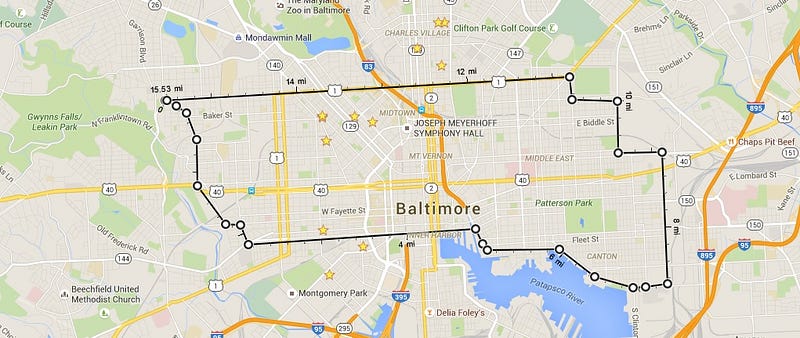
Baltimore is at its most urban in the central business district and downtown core. The area bounded by the line below is about 10–15 square miles of pre-automobile urban density. Within that line, the city has its most consistently grid-like geometry.
These ~10 square miles bordered by Baltimore’s parks and industrial areas are characterized by a more-or-less square city grid arrangement probably indicative of their development prior to the automobile, and for the most part, within the 1817 city boundary.
The other 65–70 square miles include considerable green space and industrial areas, and commercial and residential areas that steadily decrease in their density and gradually become more suburban in form.
To reach it’s potential, Baltimore needs to add urban density citywide and retrofit suburban communities with walkable urban centers. High-quality transit and complete streets infrastructure are required to move the maximum number of people in ways that allow communities to remain people oriented.
In the context of transit, the corridors provide a radial grid network of transit lines for Baltimore, providing good coverage efficiency for city destinations. That means that investments in high-quality transit service in the corridors should generally be the most effective way to serve people and destinations citywide.
The corridors move much of the automobile traffic, and by far the lions share of transit traffic. Efforts to increase the number of people switching to transit, bike, or walking should consider the whole corridor network. This is especially true given that the corridors reach into the suburbs where most of Baltimore’s commuters come from.
Though almost 700,000 transit or automobile trips occur in the corridors every day, the corridors are lined with commercial main streets, town centers, and would-be walkable residential communities — the remnants of historic communities built for transit and pedestrians. The corridors need to be able to move many people while also allowing for places that are built for people.
Transit and urban density depend on each other for success. The commercial main street communities on the corridor network provide a good foundation for rebuilding the city’s more suburban-style communities into dense, walkable, urban places.
A History of the Corridors
New York City, Philadelphia, and Boston are all a full 100 years older than Baltimore, which was not incorporated until 1798 — and was only then beginning to come into its own as an international port city.
When Baltimore incorporated in 1798, three urbanized areas combined to form the new City of Baltimore — Old Town, located where a bridge had been constructed over the Jones Falls, Baltimoretown, located essentially at the heart of the old west side, and Fell’s Point.
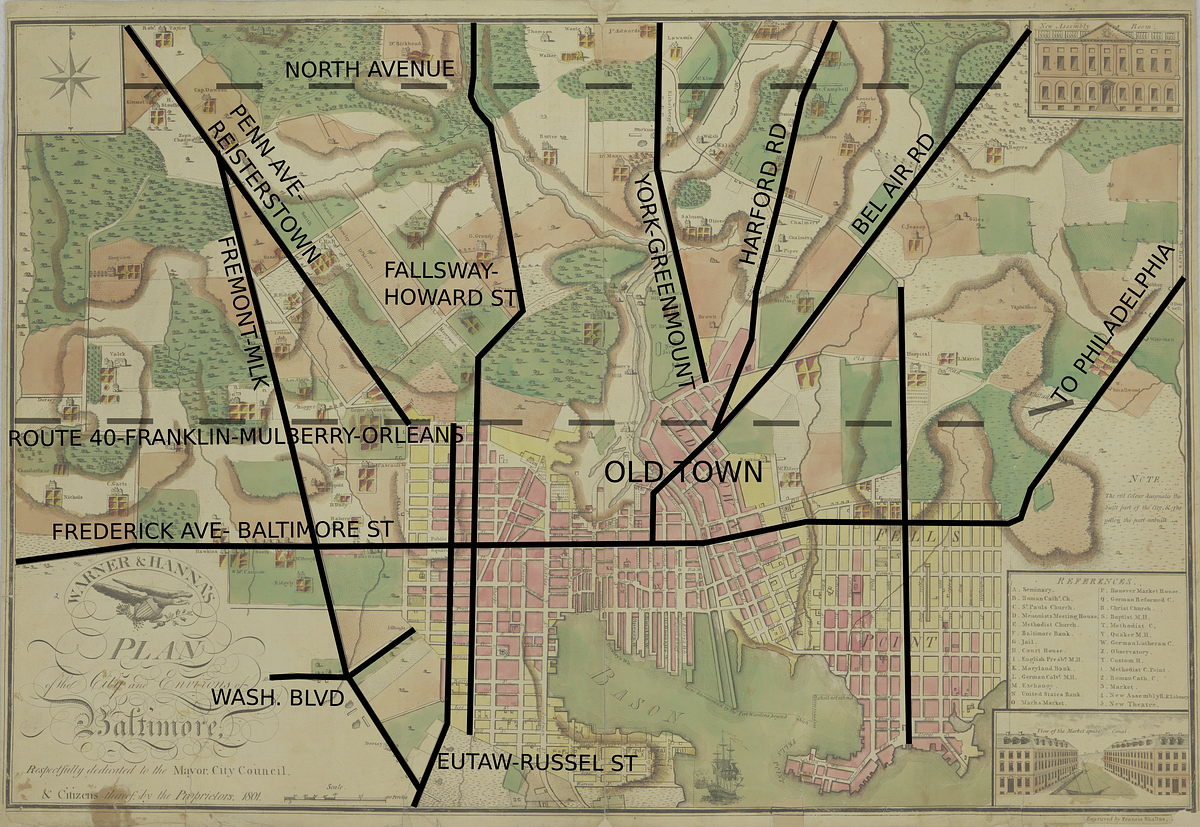
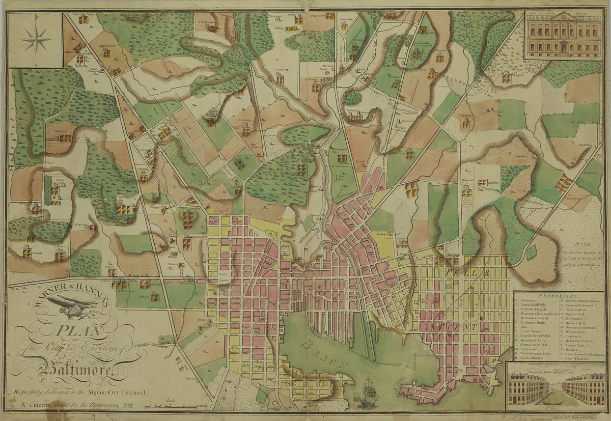
1801 — Growing According to Plan
The Warner & Hanna map, 1801, a famous early map of Baltimore City and the urbanizing portion of the county around the limits of the city proper.
Key to the early growth of the city were three things:
Baltimore’s deep-water port — depth meant greater weight and larger ships.
The Mills of the Jones Falls — itprovided hydropower in the Mill Corridor (note the many mills already in the 1801 Warner & Hanna map)
Turnpikes connecting the interior to the mills and the harbor — especially western Maryland, full of natural resources and markets for refined goods. These turnpikes carried raw materials to city mills where they were processed for global commerce via the harbor.
Maryland had been a colony for 160 years by the time modern Baltimore really began to grow, and many features of the street system existing at the turn of the 19th century are recognizable today.
Take another look at the Warner & Hanna map —
York Road, Harford Road, and Bel Air Road (called Perry Hall Rd on the map) are all named on the map, and converge at Old Town on the east bank of the Falls where an early bridge was located.
The Frederick Turnpike, today’s Frederick Avenue andthe famed “National Road” to Cumberland, Maryland, which was the original US 40 alignment, is named on the map.
The Reisterstown Turnpike (today’s Pennsylvania Avenue andfurther to the northwest, Reisterstown Road) is named.
The modern Route 40 corridor is presaged — Mulberry Street is named on the map, as is “New Street” where today’s Franklin Street runs. On the east side, the “Road to Philadelphia”, most likely modern Maryland 7, turns to the northeast.
The Howard-Fallsway Corridor is presaged as well. A portion of what is today’s realigned Howard Street was then named Cathedral Street.
Continuing south from Howard Street is a road curving to the southeast around the Middle Branch. Today, Russell Street, or the old Baltimore-Annapolis Boulevard (Maryland Route 648 — beginning just south of Horseshoe Casino) continue around the Middle Branch in this fashion.
Fremont Avenue is shown, making the connection with Pennsylvania Avenue at present-day Triangle Park. Ultimately, some of Fremont Avenue would be rerouted into Martin Luther King, Jr. Boulevard.
Broadway appears on the map, at the center of the Fell’s Point grid.
Even Washington Boulevard appears, named Road to Alexandria. (Presumably for Alexandria, Virginia. Later named Columbia Avenue before becoming Washington Boulevard).
Annexation & Growth
In her seminal early 20th century history of the city (full text here), Dr. Ruthella Bibbins notes that between 1790 and 1798, Baltimore tripled in size and septupled its exports.
Baltimore’s rapid growth immediately created a city-county conflict that has continued until modern times, though it is different in character today.
Baltimore Annexations, 1817–1918
Baltimore Annexations — Image from Suburban Growth and Municipal Annexation in Suburban Baltimore, 1745–1918 by Joseph L. Arnold, available from the Maryland State Archives, here.
City-County Conflict
The city-county conflict had two basic dimensions:
It was felt that the new suburban population in the “precincts” received benefits from city services and infrastructure that they did not pay for, and that perhaps suburban residents were choosing to locate just beyond city limits only in order to escape taxes (running up urban costs paid for by city residents).
County government was generally run by wealthy rural land owners who cared little for affairs in the populated suburbs around Baltimore, and were generally incompetent to provide services, planning acumen, development oversight, or to generally address urban needs.
“They want to receive all the benefits of the city, and then evade their share of the burdens.” — Baltimore municipal leader, 1870, speaking of population in “the Belt”
When the city sent annexation petitions to Annapolis, other primarily rural counties in Maryland joined in opposition. Though they did not fear having land and tax base annexed, those counties were wary of the growing power of Baltimore and actively sought to limit it.
The solution to this political problem was to make an offer — usually related to negotiation of taxes and benefits conferred, like municipal water — that the suburbanites could not refuse.
In 1817, the first major annexation passed. This annexation, setting North Avenue as the northern boundary of the city, encompassed Baltimore’s growth until just past the days of the Civil War.
By 1870, a new suburban community had grown up around Baltimore in an area called “the Belt.” In 1888, the Belt was annexed, too. In 1918, another annexation set the city’s borders in their present location.
Passenger Rail Connects the Region
Around 1860, Baltimore’s passenger rail system — originally running horse drawn cars — appeared and began to replace stagecoaches, or “omnibuses”.
Private companies built rail lines which were eventually consolidated into the United Railways and Electric Company in 1898. By then, the street rail network was approximately 400 miles, which was to be its peak.
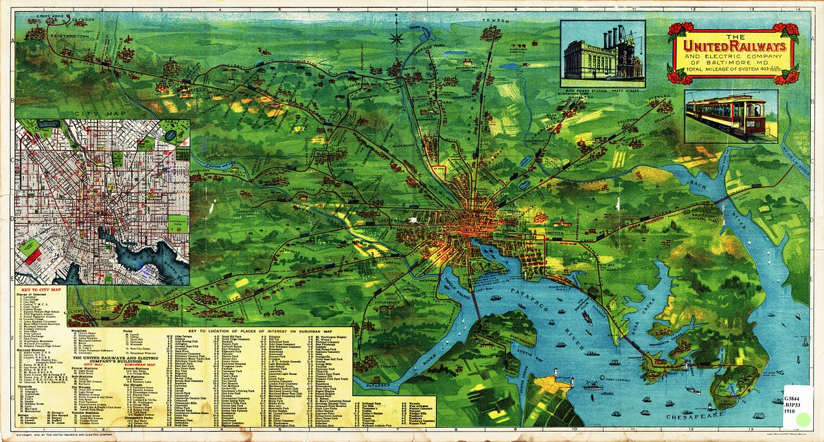
1910 — Streetcars Connect the Region
1910 — This system map created by the United Railway Company shows the full breadth of network coverage comprising Baltimore’s 403 miles of passenger rail. The key at the bottom left lists landmarks, destinations, and communities served throughout the network, including many suburban communities.
On the 1910 map, approximately 150 miles of regional passenger rail are shown as part of the United Railway and Electric system. This does not include passenger rail lines like the Washington, Baltimore, & Annapolis, which also connected the region, or eventually the B&O metropolitan service that became the MARC system in the 1970s.
Additionally, some regional lines that existing in 1910 appear to be omitted, such as the Guilford line, the Columbia Avenue (Washington Boulevard) line to Morrell Park, service past Hamilton to Parkville, or service to Randallstown via Liberty Heights.
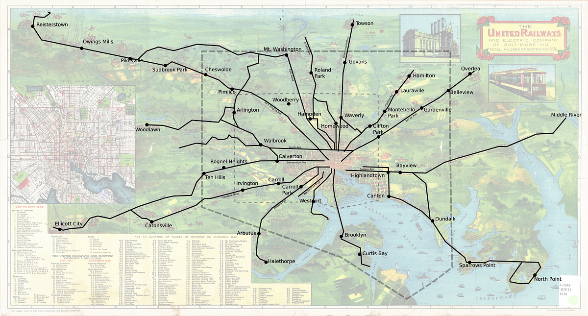
The 1910 URC Trolley Map adapted to show more clearly the regional reach of the city streetcar network. The inner dotted line shows the city’s boundary in 1910, prior to annexation in 1918. It would have taken an estimated 150 miles of rail to connect these regional destinations, using the 1910 map as a rough guide.
Population followed the streetcar lines towards the suburbs. New communities grew up along these corridors, forming the commercial main street communities we still see today.
Image from Suburban Growth and Municipal Annexation in Suburban Baltimore, 1745–1918 by Joseph L. Arnold, available from the Maryland State Archives, here.
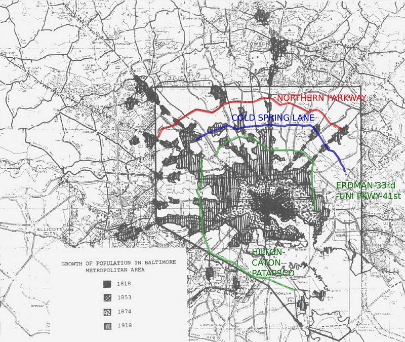
As communities grew up along radial routes like pearls on a string, desire soon arose to connect them via new circumferential corridors.
The ultimate circumferential corridor is the Baltimore Beltway. However, Baltimore has some important intracity circumferential roads, too.
The map below shows population only until 1918, but is drawn on a more recent map of regional roads. Below, intracity circumferential corridors have been highlighted.
Northern Parkway — connected North Baltimore to JFX by fusing portions of old Belvedere and Rogers Avenue
Cold Spring Lane — extended West to the JFX and beyond to Park Heights Avenue (Maryland 129)
Old MTA Route 22 — now made up of the 22 and 16 local bus routes, the green line above shows a cobbled together route serving the middle of the city, including: Edison Highway, Erdman Avenue, 33rd Street, University Parkway, 41st Street, Druid Park Drive, Hilton Parkway, Caton Avenue, and Patapsco Avenue.
Rail and Pedestrian Infrastructure Destroyed
The State Road Commission was formed in 1908, signalling the rising importance of rural and suburban road building as a public enterprise of state government. By 1915, the last private road in the state was nationalized.
Then, in 1916 a Federal Aid law was passed that would provide increasing amounts of federal money for road building. In 1922, Maryland passed its first gas tax, and drivers in Maryland’s urban areas began to pay directly for far flung expansion of the roads.
As the state road system grew, an officially numbered system of state highways was introduced, including Baltimore’s most important mobility corridors.
1929 — State Highway System
Maryland State Routes connecting with Baltimore follow the same general rail corridors served by streetcars.
During the pre-war decades, the headwaters of 20th century suburbanization began to flow. New suburbs were built for only one kind of mobility — the private car. Therefore, each new suburbanite was also a new automobile commuter.
While a streetcar might have been able to transport a few dozen people to town, one automobile now carried just one or two. Roads were soon swamped with cars.
In response, traffic engineers waged a long, devastating campaign to dismantle and reconfigure transit and pedestrian infrastructure — moving or ripping out track, chopping off feet of sidewalk or planted median to make way for more and wider lanes of automobile traffic.
How Cars Pushed Transit Off the Corridors
The impact of changes to prioritize automobiles had immediate and debilitating effect on the service quality of urban transit:
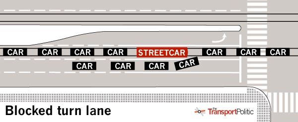
Track reconfiguration — By the 1920s, streetcar lines along radial roads like Bel Air Rd. were being reconfigured from having their own rights of way at the edge of the road with few interfering intersections, to operating in the middle of the road with many new intersections, and interference from automobile traffic during the entirety of a run.
Image Credit: Baltimore Streetcars: The Postwar Years, by Herbert H. Harwood (view photos via Google Books, here)
Image Credit: The Transport Politic. A good illustration of common problems that occur when streetcars operate in mixed traffic can be found here, and are generally illustrative of the difficulties encountered as grade separation between autos and trams is sacrificed to save cost or provide for more space for cars.
Gridlock — As the streets filled with cars, streetcar schedules became unpredictable and delays became intolerable, as tracks were obstructed by automobiles waiting at lights, waiting to enter parking garages, double parked on tracks, and just in general, flooding the streets.
Signal problems — City signal systems were programmed for the automobile, which often means putting transit at a disadvantage.
Overall loss of reliability and speed — When transit encounters traffic, they lose speed, and worse yet, become unreliable. That’s why the industry standard for an “on-time” bus in the United States is a window of time, between one minute early, and five minutes late. As recently as 2008, buses in the Houston Metro (which just underwent a famous overhaul) had only a 55% on-time percentage.
Transit speeds have continued to fall over time in Baltimore City, after getting a small boost from the changeover to buses:
Average Baltimore Streetcar Speed, 1912:13 mph
Average Baltimore Streetcar Speed, 1946:10.57 mph
Average Baltimore Bus Speed, 1946:13.16 mph
Average Baltimore Bus Speed, 2014: 11.52 mph
However, destroying transit and pedestrian infrastructure in the historic mobility corridors ultimately did not solve the problem of congestion, and soon Baltimore joined other cities in the era of the limited access expressway.
Limited Access
High-speed limited-access routes — which separate cars completely from the city streets —have been seen as the solution to congestion.
Generally, the expressways — whether built or only proposed — followed the paths of key mobility corridors:
I-95 traces a path similar to that of US 1.
The proposed I-70 would have cut through Baltimore where the Route 40 corridor does today
I-83 follows the northern part of the Fallsway-Howard corridor
I-295 follows the southern portion, elbowing the old Baltimore-Annapolis Boulevard out of the way.
Expressways in the Baltimore Region
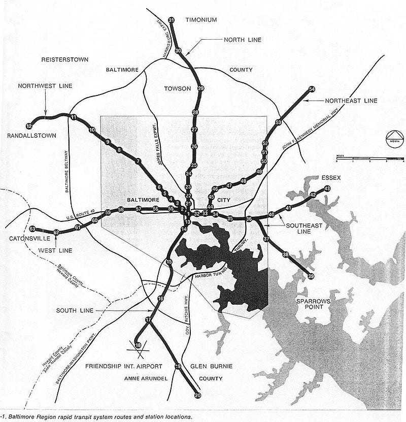
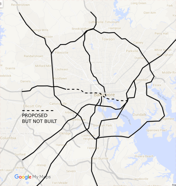
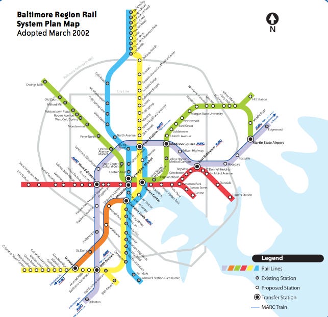
A grade-separated plan for transit emerged, too--heavy rail metro. The York-Greenmount, Reisterstown-Penn Ave, Baltimore-Frederick-Eastern Ave, and the Bel-Air Road corridors are generally served by the 1968 plan.
The 2002 rail plan is largely a refresh of the 1968 metro plan, with some differences, like abandoning heavy rail and/or complete grade-separation for the entire route, and incorporating the regional MARC system much more prominently.
Baltimore’s Mobility Corridors
Baltimore’s Mobility Corridors are:
Historic radial routes— They connected the core of old Baltimore with other communities.
Coherent, city-spanning circumferential routes — They connect communities that grew up on the radial routes.
Heavily trafficked, serving population and activity centers — They carry a volume of traffic perhaps higher than the city’s expressways, and carry the city’s highest-ridership bus routes.
Baltimore’s Mobility Corridors — the blue area represents the pre-automobile urban grid, a 10–15 mile section of the city which should be blanketed by high-density and high-quality transit service.
The Corridors
Route 40 Corridor — Comprising Edmondson, Franklin-Mulberry, Orleans, and Pulaski Highway. Security Boulevard to Woodlawn spurs off of this corridor, serving theWoodlawn/Security/CMS job center, also a designated “edge city”.
Baltimore-Frederick-Eastern Corridor — Frederick Ave in the West, and the Baltimore St. connecting with Eastern Ave/Maryland Route 150. Dundalk AvenuetoDundalk spurs off of this corridor, serving the Seagirt/Port/Amazon job center.
Fallsway-Howard-Annapolis Corridor — Falls Rd. in the North to the Fallsway/Howard Street, south via Maryland Route 648, the old Baltimore-Annapolis Boulevard starting at Russell-Camden and running to Glen Burnie. Served by the Central Light Rail. The light rail serves the job centers at Hunt Valley and Nursery Road and BWI.
Reisterstown-Penn Ave Corridor — Includes Park Heights Avenue and is served by the Baltimore Metro. Serves the Owings Mills job center and edge city.
Charles-Hanover Corridor — Historic Charles Streetin the North, south across the Hanover Street bridge becoming Maryland Route 2 to Glen Burnie and ultimately the Ritchie Highway to Annapolis.
York Road-Greenmount Corridor — Follows the old York Turnpike north to Towson and Lutherville-Timonium. Serves the job center and edge city at Towson.
North Avenue — A regional main street carrying U.S. Route 1. Runs from Walbrook Junction to Bel Air Road.
Bel-Air Road Corridor — Old Town Mall to Overlea and beyond, carries U.S. Route 1 to Pennsylvania.
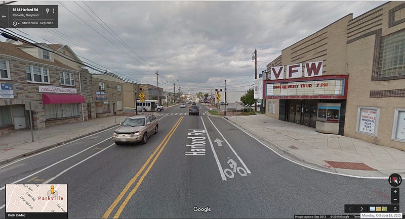
Harford Road Corridor — Harford Road from Old Town to Parkville and beyond.
Loch Raven Corridor — Running from Greenmount & 25th to Loch Raven, as Maryland 542.
Park Heights/Reisterstown Road Corridor — Beginning as Pennsylvania Avenue, Park Heights Avenue splits off from Reisterstown Road at Druid Park Drive/Liberty Square. Reisterstown proceeds as Maryland Route 140, Park Heights Avenue as Maryland Route 129.
MTA Route 22/16 Corridor — The first circumferential corridor outside of the old square pre-automobile era grid. Starts in Highlandtown on Highlandtown Avenue, runs on Edison Highway, turns northwest to Erdman Avenue, then continues northwest around Clifton Park to 33rd Street and University Parkway. 41st Street and Druid Park Drive connect the corridor with Mondawmin. West of Mondawmin, Hilton Parkway runs south and becomes Caton Avenue after crossing Frederick Avenue. Then, the corridor turns east/southeast as Patapsco Avenue, and the corridor ends in Brooklyn.
Cold Spring Lane Corridor — Old Cold Spring Lane was extended through low-density suburban neighborhood roads when I-83 came through, leaving behind this circumferential route in North Baltimore, spanning from Garrison Boulevard in the west to Walther Avenue in the east.
Northern Parkway Corridor — Forged from parts of old Rogers Avenue and Belvedere Avenue, another circumferential arterial in North Baltimore. Though its not pictured, the Route 44 bus which serves this corridor also extends southwest to Woodlawn.
Wilkens Avenue — Carries Route 1 southwest and out of the city, linking and being absorbed by Washington Boulevard south of Halethorpe.
Washington Boulevard — Old Columbia Avenue, through Morrell Park before becoming Route 1 and ultimately continuing to Washington, D.C.
Liberty Heights Avenue — Maryland State Route 26, running from the Mondawmin area out to Millford Mill and Randallstown.
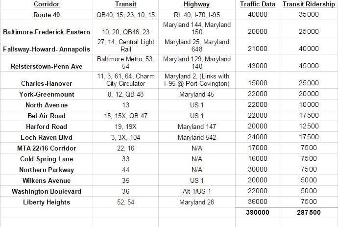
While it’s not possible to get a precise idea of how the region moves from the available data, but it is possible to get a general sense for the intensity and concentration of activity in the corridors.
Transit and Traffic in the Corridors
The corridors carry a large portion of daily automobile traffic in Baltimore and most of the transit traffic.
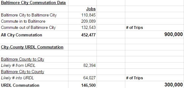
For perspective, below is a table of inter-county commutation data. This data shows the movement of people across the city’s jurisdictional boundaries each weekday.
There are 452,477 employees who commute within, into, or out of the city each day to jobs, generating around 900,000 trips per day (to work and back). Approximately 146,000 move between the city and Baltimore County’s urban-rural demarcation line (URDL) each day, or about 300,000 of those trips.
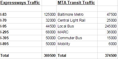
A big portion of this movement comes via the limited-access expressway routes, but even more comes from the corridors. NOTE: I-95 has a lower number below because much of the I-95 traffic is counted as I-295 into Russell Street.
If you compare the tables above,the corridors carry about as much or slightly more traffic as the expressways do, and transport a similar number of people by car to the total number of people transported by transit.
Though MTA has not made per route ridership data available, anecdotal evidence indicates that the most high traffic bus lines carry between 5,000–10,000 passengers per day.
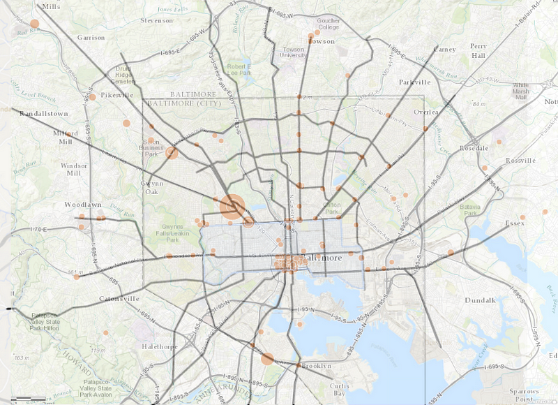
31 of MTAs 57 local bus routes are represented, plus the Central Light Rail and Baltimore Metro.Below is a map of all the bus stops in the MTA bus system with more than 500 riders.
With only a three exceptions (UMBC and two stops on Sinclair Avenue), they are all located on identified mobility corridors. Since MTA does not yet publish ridership data by individual bus route, this is the best approximation available of bus ridership by corridor.
NOTE: A line of stops runs along the path of the Baltimore Metro, generally in the Reisterstown Road corridor to Owings Mills.
The corridors map with a map of MTA’s 500+ rider bus stops. Note centers of activity downtown and at Modawmin metro bus hub
Conclusion #1 — Baltimore’s corridors provide the city with a workable radial grid network for transit
When it comes to transit network planning, a geometrically square grid is the ideal form. In Baltimore, only about 10–15 square miles of Baltimore’s ~80 miles of land is laid out in such a grid, roughly in the area delineated below.
Cities with coherent radial grids can still take advantage of the efficiency of grids. The mobility corridors could function as a radial grid and transition into a more traditional square grid downtown.
Conclusion #2 — Just like they were transformed for the automobile 100 years ago, the corridors can be transformed to transit, bike, pedestrian corridors today
Offering high-frequency transit service in the corridors, along with using complete streets principles to ensure that communities old and new can be built for people, would change the character of the corridors the same way their character was changed to make way for the automobile a century before.
Just as roads were reconfigured to allow (in theory) cars to move more quickly, they can be reconfigured to prioritize the other modes. Prioritizing the car and suburban commuters over city residents supported the hollowing out of Baltimore. Instead, the corridors can become the urban backbone of the region within a strong urban core.
A prevailing theory for transit service, (championed by Jarrett Walker & Associates), is to concentrate resources on high-ridership routes (like higher frequency) where an improvement in service will benefit a lot of people and lead to increases in ridership that benefit the whole system.
Transit agencies in cities like Washington, D.C., Seattle, and Los Angeles, are supplementing their systems of grade separated rail lines with priority bus corridors, using various techniques to improve transit travel times.
Conclusion #3 —High-quality transit and complete streets infrastructure in the corridors would allow for sprawl repairand increased urban density, transforming mobility and livability in the city.
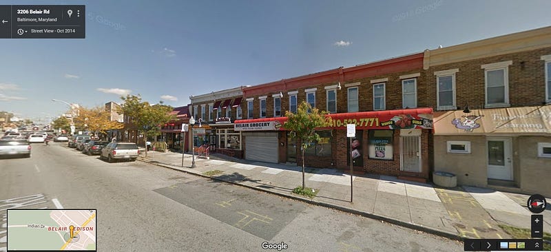
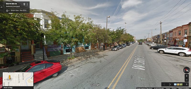
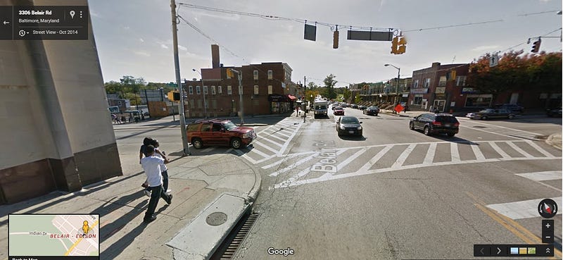
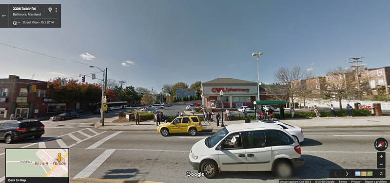
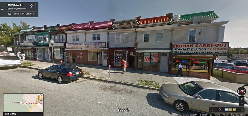
Take an intersection like Belair & Erdman, where the 22 and the several buses serving Bel Air Road intersect. There’s a coherent main street and town square, and yet for pedestrians, it’s uncomfortable to be on the street because of the high speed of travel of automobiles.
The bus stops at the Belair & Edison intersection are some of the busiest in Baltimore City.
South of Bel Air and Erdman, a commercial main street runs for a full block on the east, half a block on the right. Clifton Park makes up the other half block on the west.
Here are the commercial businesses on the west side, walk-down businesses in attractive row homes:
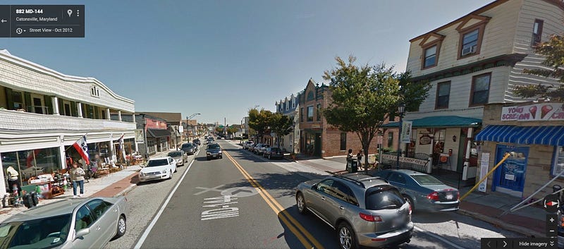
Compare the above to Hampden, with it’s angle parking, narrower travel lanes, bike lanes, street trees, and generally lower volume, calmer traffic:
The town center — 3/4 of the intersection have buildings built out to the street, and the sidewalks are fairly wide. However, the experience of being on the street is dominated by heavy and fast traffic. Bike lanes, and complete streets-style streetscaping could transform this into a place that is truly the heart of the dense, walkable, residential communities surrounding it.
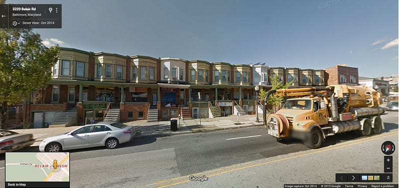
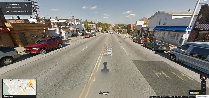
Sprawl repair needed — this building, at Bel Air & Erdman, would ideally be replaced with one minimizing or eliminating on-site parking and built out to the street:
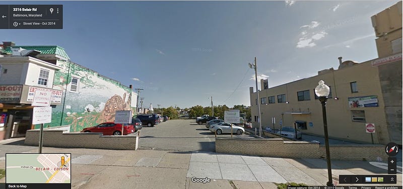
The very next parcel north from the intersection. An infill building should go here:
Commercial development continues north for several blocks:
Then, blocks further to the north, the road widens up to four lanes in addition to parking on two lanes. Here might be a great place to consider dedicated bus lanes and restricted left turns:
Conclusion #4 — Sprawl Repair is easier in the city, but the typology of linked main street communities continues into the counties.
Even though county population is dispersed, there are many old main street and town center communities in the corridors that can be reactivated.
Baltimore County’s Urban-Rural Demarcation Line (URDL) comprises 90% of the population of the county resides, in an area comprising 30% of its land.
When you start to look, old main street communities are everywhere:
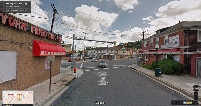
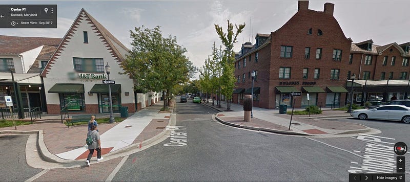
Woodlawn Village (near Woodlawn/Security job center)
 Here are the commercial businesses on the west side, walk-down businesses in attractive row homes:


No comments:
Post a Comment